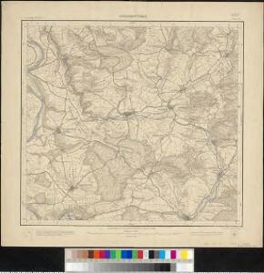
Maps of Großbottwar

Meßtischblatt 33 : Grossbottwar, 1901
1 : 250000 Grossbottwar. - 1:25000. - Stuttgart, 1901. - 1 Kt.
Les environs d'Hailbron
1 Karte : Kupferdruck ; 23 x 29 cm Nolin chez I. B. Nolin sur le quay de l'Horloge du Palais
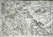
Gegend des Neckar-Stroms von Lauffen bis Wimpfen mit den Campements der Teutschen 1693 u. A. 1734
Mollova mapová sbírka Riecke, Gustav Friedrich Homann, Johann Baptista - dědici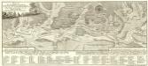
Plan Von den Beyden Campements wie die hohe Allierte Kaÿserliche Reichs-Armée bey der Stadt Heilbronn Anno 1693 und Anno 1734 im Lager gestanden
Mollova mapová sbírka Riecke, Gustav Friedrich Bodenehr, Gabriel
Geographica Provinciarum Sveviae Descriptio =
Mollova mapová sbírka Hurter, Johann Christoph Bodenehr, Gabriel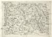
Geographica Provinciarum Sveviae Descriptio :
Mollova mapová sbírka Hurter, Johann Christoph Küsel, Melchior Bodenehr, Johann Georg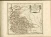

Suevia Universa
1 : 170000 Mollova mapová sbírka Michal, Jacques de Seutter, Matthäus Seutter, Matthäus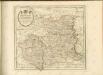

Carlsruhe - Stuttgart
1 : 200000 Herder, Benjamin
Suevia Universa :
1 : 170000 Mollova mapová sbírka Michal, Jacques de Seutter, Matthäus Seutter, Matthäus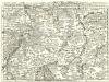
Staaten ahm Rhein, und Necker
1 : 180000 Mollova mapová sbírka Person, Nikolaus Person, Nicolas
Stuttgart 128, uit: Special-Karte von Mittel-Europa / nach amtlichen Quellen bearbeitet von W. Liebenow
1 : 300000 titelvariant: W. Liebenow's Mittel-Europa; Annotatie: Titel boven de bladen: W. Liebenow's Mittel-Europa Johannes Wilhelm Liebenow 1822-1897 Frankfurt a. M. : Ludwig Ravenstein
Suevia universa IX. tabulis delineata, 2
1 Blatt : s.n.
Des Herzogthums Würtemberg nordöstliche Aemter mit den freyen Reichsstädten Heilbronn, Wimpfen und Eslingen
1 Karte : Kupferdruck ; 23 x 26 cm Reilly F. J. J. von Reilly
Stuttgart 128, uit: [W. Liebenow's Special-Karte von Mittel-Europa]
1 : 300000 titelvariant: W. Liebenow's Mittel-Europa; Annotatie: Titel boven de bladen: W. Liebenow's Mittel-Europa Johannes Wilhelm Liebenow 1822-1897 Hannover : Hermann Oppermann
Suevia universa IX. tabulis delineata, 1
1 Blatt : s.n.
Geognostische Reise-Karte der Umgegend von Heidelberg
1 : 250000 Groos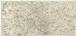
S.R.Imp. Circuli Franconici Geographica Delineatio Francken-Land mit Seinen Gräntzen
Mollova mapová sbírka Endter, Wolfgang Moritz Endter, Wolfgang Moritz
Des Herzogthums Würtemberg nordwestliche Aemter mit der freyen Reichsstadt Weil
1 Karte : Kupferdruck ; 23 x 26 cm Reilly F. J. J. von Reilly
Le Theatre de la Guerre Sur le Haut Rhein
1 : 142000 Mollova mapová sbírka Sanson, Guillaume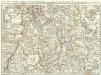
Novissima Statuum Imperii Intra Rhenum & Tuberum Repraesentatio
1 : 210000 Mollova mapová sbírka Buna, Wilhelm C. Reinhardt, Andreas Broenner, Heinrich Ludwig
Per Inclyti Circuli Suevici Supremorum Ordinum :
1 : 160000 Mollova mapová sbírka Pfeffel, Johann Andreas Homann, Johann Baptista - dědici
Partie Orientale du Palatinat et Eslectorat du Rhein. Les Eveschés de Spire, de Wormes et le Comté de Linange
1 : 260000 Mollova mapová sbírka Sanson, Guillaume Jaillot, Alexis Hubert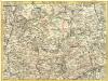
Pars Sueviae Borealior
1 : 250000 Mollova mapová sbírka Delisle, Guillaume Wolff, Jeremias
Nova et accuratißima Ducatus Wurtenbergici
1 : 300000 Mollova mapová sbírka Seutter, Matthäus Seutter, Matthäus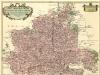
Carte tres Particuliere du Duché de Wirtemberg
1 : 240000 Mollova mapová sbírka Fer, Nicolas de Loon, Herman van L'Isle, Guillaume de
Comitatvs Wertheimici Finitimarvmqve Regionvm Nova et Exacta descriptio
1 : 110000 Mollova mapová sbírka Valk, Gerhard Schenk, Peter I
Comitatvs Wertheimici Finitimarvmqve Regionvm Nova et Exacta descriptio
1 : 110000 Mollova mapová sbírka Janssonius, Johannes Janssonius, Johannes I