Maps of Gschwend

Meßtischblatt 47 = [7024] : Gschwend, 1904
1 : 250000 Gschwend. - 1:25000. - Stuttgart, 1904. - 1 Kt.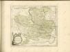

Comitatus Limpvrgensis Mandato Speciali imperatium mensuratus & hac Tabula geographica comprehensus In lucem prodit Curis
1 : 70000 Mollova mapová sbírka Homann, Johann Baptist Homann, Johann Baptista - dědici
171. Göppingen, uit: Topographische Uebersichtskarte des Deutschen Reiches / herausgegeben v. d. Kartogr. Abt. d. Königl. Preuß. Landesaufnahme
1 : 200000 titelvariant: Topogr. Übersichtskarte des Deutschen Reiches; Annotatie: Titel boven bladen ook: Topogr. Übersichtskarte des Deutschen Reiches; Annotatie geografische gegevens: Op elk blad twee maatstokken: 10 Kilometer = 5,5 cm; 1 geogr. Meile = 3,6 cm; Legenda onder op elk blad Königlich Preußische Landesaufnahme. Kartographische Abtheilung [S.l : Königlich Preußische Landesaufnahme, Kartographische Abtheilung]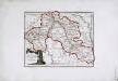
Die freye Reichsstadt Schwæbisch Hall mit ihrem Gebiethe
1 Karte : Kupferdruck ; 21 x 27 cm Reilly F. J. J. von Reilly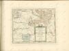

Charte von dem Fürstenthum Hohenlohe, und der Grafschafft Limpurg
1 : 150000 Hohenlohe (Německo) Hammer, C.F.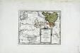
Die gefürstete Probstey Ellwangen
1 Karte : Kupferdruck ; 18 x 23 cm Reilly F. J. J. von Reilly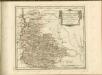

Comitatvs Wertheimici Finitimarvmqve Regionvm Nova et Exacta descriptio
1 : 110000 Mollova mapová sbírka Valk, Gerhard Schenk, Peter I
Comitatvs Wertheimici Finitimarvmqve Regionvm Nova et Exacta descriptio
1 : 110000 Mollova mapová sbírka Janssonius, Johannes Janssonius, Johannes I
Suevia Universa :
1 : 170000 Mollova mapová sbírka Michal, Jacques de Seutter, Matthäus Seutter, Matthäus
Stuttgart 128, uit: Special-Karte von Mittel-Europa / nach amtlichen Quellen bearbeitet von W. Liebenow
1 : 300000 titelvariant: W. Liebenow's Mittel-Europa; Annotatie: Titel boven de bladen: W. Liebenow's Mittel-Europa Johannes Wilhelm Liebenow 1822-1897 Frankfurt a. M. : Ludwig Ravenstein
Suevia universa IX. tabulis delineata, 2
1 Blatt : s.n.
Des Herzogthums Würtemberg nordöstliche Aemter mit den freyen Reichsstädten Heilbronn, Wimpfen und Eslingen
1 Karte : Kupferdruck ; 23 x 26 cm Reilly F. J. J. von Reilly
Stuttgart 128, uit: [W. Liebenow's Special-Karte von Mittel-Europa]
1 : 300000 titelvariant: W. Liebenow's Mittel-Europa; Annotatie: Titel boven de bladen: W. Liebenow's Mittel-Europa Johannes Wilhelm Liebenow 1822-1897 Hannover : Hermann Oppermann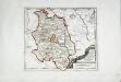
Die Grafschaft Oetingen
1 Karte : Kupferdruck ; 23 x 27 cm Reilly F. J. J. von Reilly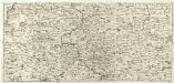
S.R.Imp. Circuli Franconici Geographica Delineatio Francken-Land mit Seinen Gräntzen
Mollova mapová sbírka Endter, Wolfgang Moritz Endter, Wolfgang Moritz
Le Theatre de Bellone :
Mollova mapová sbírka Schenk, Pieter Braakman, Adriaan
Generalkarte von Württemberg: Blatt II
1 : 1500000 Terrainzeichnung: Bach, Topograf und Hauptmann Lithografie: Rebmann und Sommer Herausgeber: K. statistisch-topografisches Büro
Le Theatre de la Guerre Sur le Haut Rhein
1 : 142000 Mollova mapová sbírka Sanson, Guillaume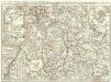
Novissima Statuum Imperii Intra Rhenum & Tuberum Repraesentatio
1 : 210000 Mollova mapová sbírka Buna, Wilhelm C. Reinhardt, Andreas Broenner, Heinrich Ludwig
Per Inclyti Circuli Suevici Supremorum Ordinum :
1 : 160000 Mollova mapová sbírka Pfeffel, Johann Andreas Homann, Johann Baptista - dědici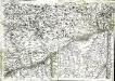
Geographica provinciarum Sueviae descriptio, 4
4 Blätter : Johann Georg Bodenehr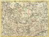
Pars Sueviae Borealior
1 : 250000 Mollova mapová sbírka Delisle, Guillaume Wolff, Jeremias
Nova et accuratißima Ducatus Wurtenbergici
1 : 300000 Mollova mapová sbírka Seutter, Matthäus Seutter, Matthäus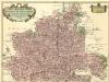
Carte tres Particuliere du Duché de Wirtemberg
1 : 240000 Mollova mapová sbírka Fer, Nicolas de Loon, Herman van L'Isle, Guillaume de
Partie Meridionale de la Souabe
1 : 250000 Mollova mapová sbírka Delisle, Guillaume Cordier, Louis L'Isle, Guillaume de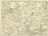
![Meßtischblatt 47 = [7024] : Gschwend, 1904](https://images-2.georeferencer.com/images/iiif/837387658280/full/,300/0/native.jpg)

