Maps of Weissach

Maps of Weissach

$title$

Meßtischblatt 55 = [7119] : Weissach, 1936

1 : 250000 Weissach. - 1:25000. - Stuttgart, 1936. - 1 Kt.
$title$

Meßtischblatt 55 = [7119] : Weissach, 1900

1 : 250000 Weissach. - 1:25000. - Stuttgart, 1900. - 1 Kt.
$title$

Le Flambeau de la Guerre Allumee au Rhin

Mollova mapová sbírka Delisle, Guillaume Schenk, Peter II
$title$

Geographica Provinciarum Sveviae Descriptio =

Mollova mapová sbírka Hurter, Johann Christoph Bodenehr, Gabriel
$title$

Geographica Provinciarum Sveviae Descriptio =

Mollova mapová sbírka Hurter, Johann Christoph Bodenehr, Johann Georg
$title$

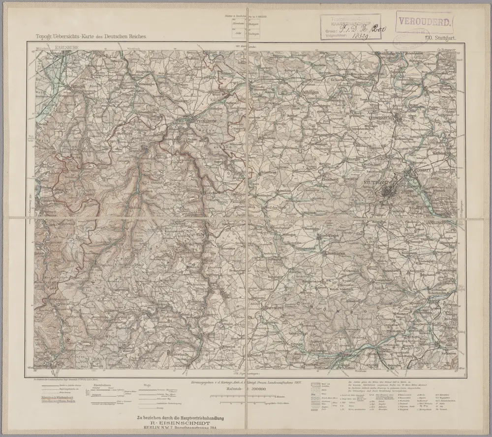
170. Stuttgart, uit: Topographische Uebersichtskarte des Deutschen Reiches / herausgegeben v. d. Kartogr. Abt. d. Königl. Preuß. Landesaufnahme

1 : 200000 titelvariant: Topogr. Übersichtskarte des Deutschen Reiches; Annotatie: Titel boven bladen ook: Topogr. Übersichtskarte des Deutschen Reiches; Annotatie geografische gegevens: Op elk blad twee maatstokken: 10 Kilometer = 5,5 cm; 1 geogr. Meile = 3,6 cm; Legenda onder op elk blad Königlich Preußische Landesaufnahme. Kartographische Abtheilung [S.l : Königlich Preußische Landesaufnahme, Kartographische Abtheilung]
$title$

Des Herzogthums Würtemberg nordwestliche Aemter mit der freyen Reichsstadt Weil : Nro. 187

Reilly, Franz Johann Joseph von
$title$

$title$

$title$

Carlsruhe - Stuttgart

1 : 200000 Herder, Benjamin
$title$

Die untere Markgrafschaft Baaden oder die Grafschaft Eberstein mit den Durlachischen Landen

1 Karte : Kupferdruck ; 18 x 24 cm Reilly F. J. J. von Reilly
$title$

Staaten ahm Rhein, und Necker

1 : 180000 Mollova mapová sbírka Person, Nikolaus Person, Nicolas
$title$

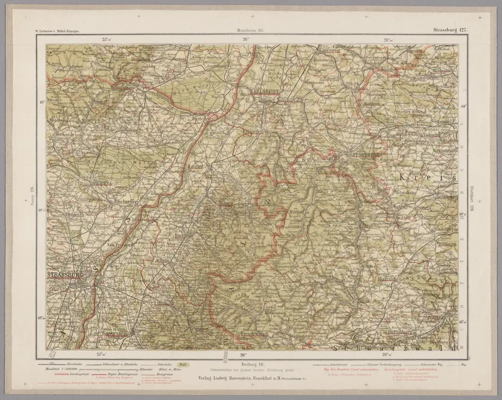
Strassburg 127, uit: Special-Karte von Mittel-Europa / nach amtlichen Quellen bearbeitet von W. Liebenow

1 : 300000 titelvariant: W. Liebenow's Mittel-Europa; Annotatie: Titel boven de bladen: W. Liebenow's Mittel-Europa Johannes Wilhelm Liebenow 1822-1897 Frankfurt a. M. : Ludwig Ravenstein
$title$

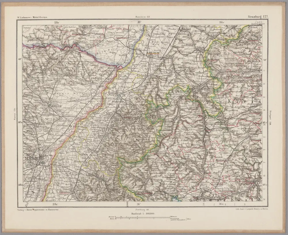
Strasburg 127, uit: [W. Liebenow's Special-Karte von Mittel-Europa]

1 : 300000 titelvariant: W. Liebenow's Mittel-Europa; Annotatie: Titel boven de bladen: W. Liebenow's Mittel-Europa Johannes Wilhelm Liebenow 1822-1897 Hannover : Hermann Oppermann
$title$

S.R.Imp. Circuli Franconici Geographica Delineatio Francken-Land mit Seinen Gräntzen

Mollova mapová sbírka Endter, Wolfgang Moritz Endter, Wolfgang Moritz
$title$

Des Herzogthums Würtemberg nordwestliche Aemter mit der freyen Reichsstadt Weil

1 Karte : Kupferdruck ; 23 x 26 cm Reilly F. J. J. von Reilly
$title$

Le Theatre de la Guerre Sur le Haut Rhein

1 : 142000 Mollova mapová sbírka Sanson, Guillaume
$title$

Carte topographique d'Allemagne

1 : 218000 Alsasko (Francie) Jaeger, Johann Wilhelm Abraham Facius, Johann Gottlieb chez I.W.A. Iaeger
$title$

Carte topographique d'Allemagne

1 : 218000 Alsasko (Francie) Jaeger, Johann Wilhelm Abraham I. W. A. Iaeger
$title$

Nova et accuratißima Ducatus Wurtenbergici

1 : 300000 Mollova mapová sbírka Seutter, Matthäus Seutter, Matthäus
$title$

Carte tres Particuliere du Duché de Wirtemberg

1 : 240000 Mollova mapová sbírka Fer, Nicolas de Loon, Herman van L'Isle, Guillaume de
$title$

Generalkarte von Württemberg: Blatt I

1 : 1500000 Mit Übersichtskarte. Terrainzeichnung: Bach, Topograf und Hauptmann Lithografie: Rebmann und Sommer Herausgeber: K. statistisch-topografisches Büro
$title$

Geographica provinciarum Sueviae descriptio, 3

4 Blätter : Johann Georg Bodenehr
$title$

Carte particulìere des pays quì sont sítuéz entre la Rhein, la Saare, la Mosselle et la basse Alsace, contenant partìe du Palatinat, des Electorats de Mayence de Treves des Eveschés de Spìres et de Wormes avec les Duchés de Deuxponts et des Sìmmeren.

from Atlas françois : contenant les cartes geographiques dans lesquelles sont tres exactement remarquez les empires, monarchies, royaumes et estats de l'Europe, de l'Asie, de l'Afrique et l'Amérique : avec les tables et cartes particulieres de France, de Flandre, d'Allemagne, d'Espagne et d'Italie / par ... Hubert Iaillot, geographe ordinaire ...
$title$

Circuli Franconicae pars occidentalis, exhibens simul integrum fere electoratum Moguntinum

1 : 860000 Hesensko (Německo) Homann, Johann Baptist Schönborn, Lothar Franz von J. B. Homann
$title$

Circuli Franconicae pars occidentalis, exhibens simul integrum fere electoratum Moguntinum

1 : 860000 Hesensko (Německo) Homann, Johann Baptist Lothario, Francisco J. B. Homann
$title$

Die untere Markgrafschaft Baaden oder die Grafschaft Eberstein mit den Durlachischen Landen : Nro. 192

Reilly, Franz Johann Joseph von
$title$

Suevia universa IX. tabulis delineata, 4

1 Blatt : s.n.
$title$

Kriegs-Theatrum.

Mollova mapová sbírka Lidl, Johann Jakob Lidl, Johann Jacob
$title$

Cursus Rheni infra Argentoratum usq; ad Wormatiam, cum adjacentibus Regionibus

1 : 2900000 Mollova mapová sbírka Seutter, Matthäus Seutter, Matthäus
© MapTiler © OpenStreetMap contributors
How does it work?
These instructions will show you how to find historical maps online.
Getting started
Type the place name in the search box to find the exact location. You can further adjust the search by zooming in and out.
Zoom
Zoom in and out with the buttons or use your mouse or touchpad natively.
Exact Area tool
Click here and draw a rectangle over the map to precisely define the search area.
Set filters
Narrow your search with advanced settings, such as Years (from/to), Fulltext, Publisher, etc.
Results
See the results of your search on the right side. You can scroll down to find more maps of this location.
?

Download OldMapsOnline Mobile