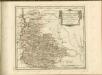
Maps of Ostfildern

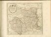
Meßtischblatt [7221] : Stuttgart, 1930
1 : 250000 Stuttgart. - 2. Ausg. - 1:25000. - Stuttgart, 1930. - 1 Kt.
Town Plan of Stuttgart, 1936 - sheet 2.
This map was copied from a 1936 German map and publiched by the British War Office in 1944. Scale 1 : 19,000. [G.S.G.S. No. 4480] Great Britain. War Office.
Plan von Hohenheim
Böhnen, L. v.; Abel, Gottlieb Friedrich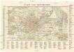
Plan von Stuttgart
1 : 12000 Stuttgart (Německo)
Plan oder Wegweiser von Stuttgart mit Bezeichnung der Viertel, Strassen und Hausnummern
1 : 5000 Stuttgart : G. Ebner'sche Kunsthandlung
STUTGARDIA
Stuttgart (Německo) Seutter, Matthäus a M. Seutter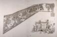
Les Plantages De Hohenheim
Böhnen, L. v.
Projet d'une piece angloise qui existe a Hohenheim
1 : 500 Hohenheim (Stuttgart, Německo) Scheidlen, CH. F. Seybold, I.
Plan von STUTTGART
1 : 11200 Stuttgart (Německo)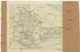
Plan von Stuttgart
1 : 12000 Stuttgart (Německo)
Stutgardia Würtenbergensis ducatia metropolis arcem habens elegantissimam, multas. amöenitates
Stuttgart (Německo) Seutter, Matthäus M. Seutter
Plan Geometrique Et Perspective De La Ville Capitale De Stouttgard Dans Le Duchè De Wirttemberg
Riediger, Johann Adam
Stuttgart
Wagner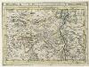
Stutgart, mit dero Gegend auf 2 Stund.
1 : 150000 Mollova mapová sbírka Bodenehr, Gabriel H., R.
Stuttgart

Plan der ersten Königl. Haupt und Residenz Stadt Stuttgart im Jahr 1811
Stuttgart (Německo) Waltter Ringlin, Johann G. in der J.G. Cotta'schen Buchhandlung
Karte der Umgegend von Stuttgart
1 : 70000 Stuttgart-oblast (Německo) Hoffmann, Carl Carl Hoffmann
Germany [Town plans of], Stuttgart
Town plans of Germany, GSGS 4480. Great Britain. War Office. [London] : War Office
170. Stuttgart, uit: Topographische Uebersichtskarte des Deutschen Reiches / herausgegeben v. d. Kartogr. Abt. d. Königl. Preuß. Landesaufnahme
1 : 200000 titelvariant: Topogr. Übersichtskarte des Deutschen Reiches; Annotatie: Titel boven bladen ook: Topogr. Übersichtskarte des Deutschen Reiches; Annotatie geografische gegevens: Op elk blad twee maatstokken: 10 Kilometer = 5,5 cm; 1 geogr. Meile = 3,6 cm; Legenda onder op elk blad Königlich Preußische Landesaufnahme. Kartographische Abtheilung [S.l : Königlich Preußische Landesaufnahme, Kartographische Abtheilung]
Nordwestlicher Abhang der Schwäbischen Alp
Geologischer Atlas zur Naturgeschichte der Erde Leonhard, Carl Cäsar von E. Schweizerbart'sche Verlagsbuchhandlung
Geographica Provinciarum Sveviae Descriptio =
Mollova mapová sbírka Hurter, Johann Christoph Bodenehr, Johann Georg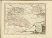

Carlsruhe - Stuttgart
1 : 200000 Herder, Benjamin
Suevia Universa :
1 : 170000 Mollova mapová sbírka Michal, Jacques de Seutter, Matthäus Seutter, Matthäus
Stuttgart 128, uit: Special-Karte von Mittel-Europa / nach amtlichen Quellen bearbeitet von W. Liebenow
1 : 300000 titelvariant: W. Liebenow's Mittel-Europa; Annotatie: Titel boven de bladen: W. Liebenow's Mittel-Europa Johannes Wilhelm Liebenow 1822-1897 Frankfurt a. M. : Ludwig Ravenstein
Suevia universa IX. tabulis delineata, 2
1 Blatt : s.n.
Des Herzogthums Würtemberg nordöstliche Aemter mit den freyen Reichsstädten Heilbronn, Wimpfen und Eslingen
1 Karte : Kupferdruck ; 23 x 26 cm Reilly F. J. J. von Reilly
![Meßtischblatt [7221] : Stuttgart, 1930](https://images-2.georeferencer.com/images/iiif/335569418289/full/,300/0/native.jpg)

