Maps of Landkreis Freudenstadt

Meßtischblatt [7517] : Dornstetten (Württ.). Dettingen (Preuß.), 1909
1 : 250000 Dornstetten (Württ.). Dettingen (Preuß.). - 1:25000. - Stuttgart, 1909. - 1 Kt.
Le Flambeau de la Guerre Allumee au Rhin
Mollova mapová sbírka Delisle, Guillaume Schenk, Peter II
Le Flambeau de la Guerre Allumee au Rhin
Mollova mapová sbírka Delisle, Guillaume Schenk, Peter II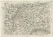
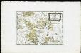
Geographica Provinciarum Sveviae Descriptio =
Mollova mapová sbírka Hurter, Johann Christoph Bodenehr, Johann Georg
Geographica Provinciarum Sveviae Descriptio =
Mollova mapová sbírka Hurter, Johann Christoph Bodenehr, Gabriel
178. Sigmaringen, uit: Topographische Uebersichtskarte des Deutschen Reiches / herausgegeben v. d. Kartogr. Abt. d. Königl. Preuß. Landesaufnahme
1 : 200000 titelvariant: Topogr. Übersichtskarte des Deutschen Reiches; Annotatie: Titel boven bladen ook: Topogr. Übersichtskarte des Deutschen Reiches; Annotatie geografische gegevens: Op elk blad twee maatstokken: 10 Kilometer = 5,5 cm; 1 geogr. Meile = 3,6 cm; Legenda onder op elk blad Königlich Preußische Landesaufnahme. Kartographische Abtheilung [S.l : Königlich Preußische Landesaufnahme, Kartographische Abtheilung]
[Carte eines Theils des Schwartzwaldes]

Suevia Universa :
1 : 170000 Mollova mapová sbírka Michal, Jacques de Seutter, Matthäus Seutter, Matthäus
Des Herzogthums Würtemberg westsüdliche Aemter mit der freyen Reichsstadt Reutlingen : Nro. 188
Reilly, Franz Johann Joseph von
Tubingen
1 : 200000 Herder, Benjamin

Die untere Markgrafschaft Baaden oder die Grafschaft Eberstein mit den Durlachischen Landen
1 Karte : Kupferdruck ; 18 x 24 cm Reilly F. J. J. von Reilly
March. Badensis pars, duc. septentrio Wurtenbergici pars
Bádensko (Německo)
Kriegs-Theatrum.
Mollova mapová sbírka Lidl, Johann Jakob Lidl, Johann Jacob
Des Herzogthums Würtemberg westsüdliche Aemter mit der freyen Reichsstadt Reutlingen
1 Karte : Kupferdruck ; 23 x 26 cm Reilly F. J. J. von Reilly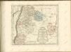
Die Landgrafschaft Nellenburg die Landvogtey Altorf die Grafschaft Hohenberg und die kleinern durch das östreichische Schwaben zerstreuten Besitzungen mit der Stadt Kostanz und den vier Donaustaedten : Nro. 153
Reilly, Franz Johann Joseph von
Die obere Markgrafschaft Baaden oder die Markgrafschaft Hochberg
1 Karte : Kupferdruck ; 21 x 24 cm Reilly F. J. J. von Reilly
Tribocci
1 : 240000 Mollova mapová sbírka Sanson, Guillaume Mariette, Pierre Sanson, Guillaume
Le Theatre de Bellone :
Mollova mapová sbírka Schenk, Pieter Braakman, Adriaan
Carte topographique d'Allemagne
1 : 218000 Alsasko (Francie) Jaeger, Johann Wilhelm Abraham Facius, Johann Gottlieb chez I.W.A. Iaeger
Carte topographique d'Allemagne
1 : 218000 Alsasko (Francie) Jaeger, Johann Wilhelm Abraham I. W. A. Iaeger
Département du Bas Rhin
1 Karte : Kupferdruck ; 49 x 48 cm Houdan au bureau de l'atlas national rue de la Harpe no. 26, et au dépot du dit atlas rue de la Monnoye no. 5
Generalkarte von Württemberg: Blatt III
1 : 1500000 Terrainzeichnung: Bach, Topograf und Hauptmann Lithografie: Rebmann und Sommer Herausgeber: K. statistisch-topografisches Büro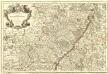
L'Alsace Divisée En Ses Principales Parties.
1 : 250000 Mollova mapová sbírka Jaillot, Alexis-Hubert Jaillot, Alexis Hubert
Cursus Rheni supra Argentoratum et Regiones Adiacentes
1 : 2900000 Mollova mapová sbírka Seutter, Matthäus Seutter, Matthäus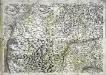
Geographica provinciarum Sueviae descriptio, 3
4 Blätter : Johann Georg Bodenehr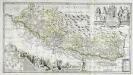
Vera totius marchionatus Badensis, et Hochbergensis
1 Karte auf 2 Blatt : Kupferdruck ; 43 x 80 cm Janssonius van Waesbergen; Pitt; Swart; Morell; Beuch excudebat Janssonio-Waesbergii Moses Pitt et Stephanus Swart
Geographica Sueviæ universæ descriptio, 3
1 Blatt : Homännische Erben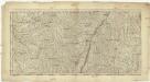
![Meßtischblatt [7517] : Dornstetten (Württ.). Dettingen (Preuß.), 1909](https://images-2.georeferencer.com/images/iiif/526115940163/full/,300/0/native.jpg)

