Maps of Buxheim

Maps of Buxheim

$title$

Meßtischblatt [7926] : Erolzheim, 1915

1 : 250000 Erolzheim. - 1:25000. - Stuttgart, 1915. - 1 Kt.
$title$

Biberach, Guttenzell, Munchrott, Buxheim a okolí]

Mollova mapová sbírka Bodenehr, Gabriel Bodenehr, Gabriel
$title$

Territorium der des H. R. R. Statt Memmingen samt denen angräntzenden Herrschafften.

1 : 2800 Mollova mapová sbírka Bodenehr, Gabriel Bodenehr, Gabriel
$title$

Geographica Provinciarum Sveviae Descriptio =

Mollova mapová sbírka Hurter, Johann Christoph Bodenehr, Johann Georg
$title$

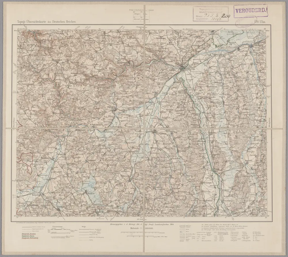
179. Ulm, uit: Topographische Uebersichtskarte des Deutschen Reiches / herausgegeben v. d. Kartogr. Abt. d. Königl. Preuß. Landesaufnahme

1 : 200000 titelvariant: Topogr. Übersichtskarte des Deutschen Reiches; Annotatie: Titel boven bladen ook: Topogr. Übersichtskarte des Deutschen Reiches; Annotatie geografische gegevens: Op elk blad twee maatstokken: 10 Kilometer = 5,5 cm; 1 geogr. Meile = 3,6 cm; Legenda onder op elk blad Königlich Preußische Landesaufnahme. Kartographische Abtheilung [S.l : Königlich Preußische Landesaufnahme, Kartographische Abtheilung]
$title$

Die Lande der Grafen Fugger

1 Karte : Kupferdruck ; 20 x 25 cm Reilly F. J. J. von Reilly
$title$

Suevia Universa :

1 : 170000 Mollova mapová sbírka Michal, Jacques de Seutter, Matthäus Seutter, Matthäus
$title$

Umgegend von Ulm

1 : 200000 Kartographischen Abtheilung konigl Preuss
$title$

Suevia universa IX. tabulis delineata, 6

1 Blatt : s.n.
$title$

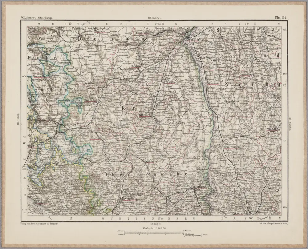
Ulm 142, uit: [W. Liebenow's Special-Karte von Mittel-Europa]

1 : 300000 titelvariant: W. Liebenow's Mittel-Europa; Annotatie: Titel boven de bladen: W. Liebenow's Mittel-Europa Johannes Wilhelm Liebenow 1822-1897 Hannover : Hermann Oppermann
$title$

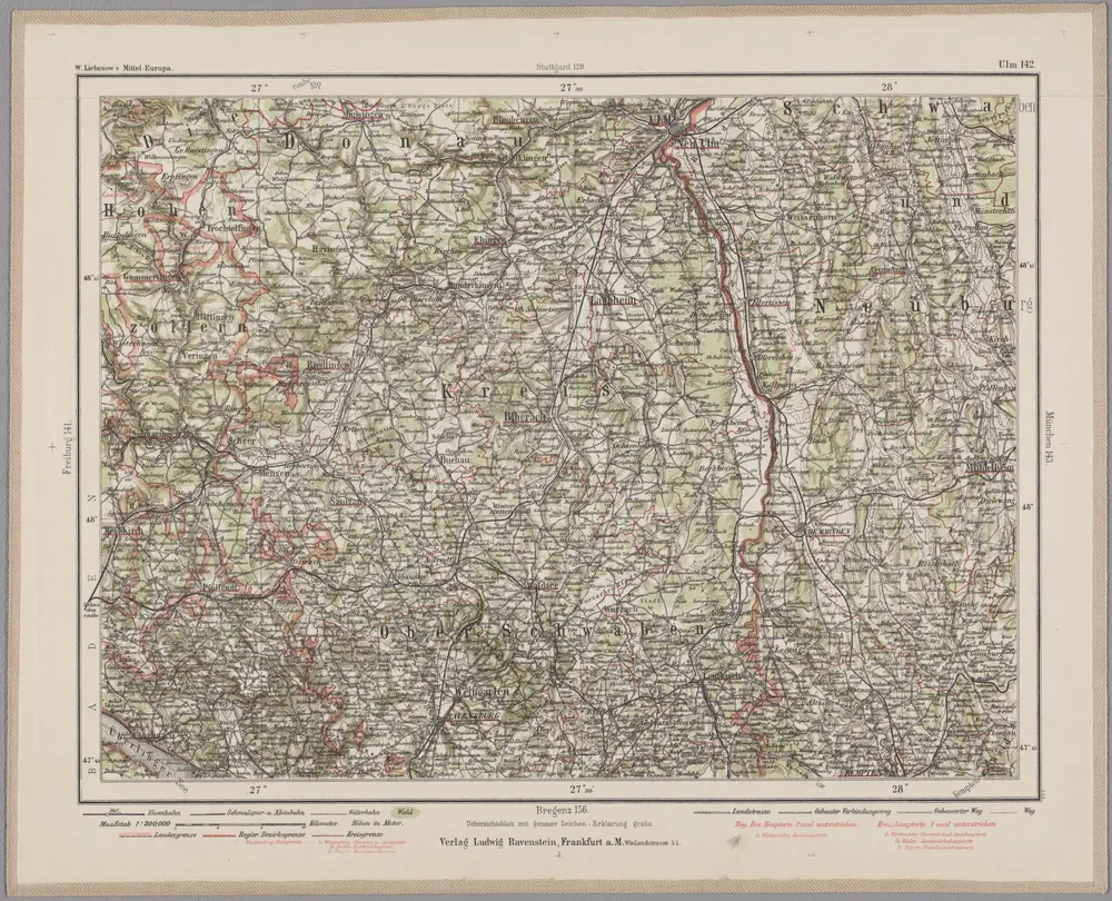
Ulm 142, uit: Special-Karte von Mittel-Europa / nach amtlichen Quellen bearbeitet von W. Liebenow

1 : 300000 titelvariant: W. Liebenow's Mittel-Europa; Annotatie: Titel boven de bladen: W. Liebenow's Mittel-Europa Johannes Wilhelm Liebenow 1822-1897 Frankfurt a. M. : Ludwig Ravenstein
$title$

Suevia universa IX. tabulis delineata, 5

1 Blatt : s.n.
$title$

Le Theatre de Bellone :

Mollova mapová sbírka Schenk, Pieter Braakman, Adriaan
$title$

Ilerae Amnis ac Vtrinqve adiacentis Alemanniae Geographica descriptio

1 : 120000 Mollova mapová sbírka Hurter, Johann Christoph Custos, Raphael Hurter, Christoph
$title$

Lacus Constan. XX. Tab. Nova. [Karte], in: Geographia universalis vetus et nova complectens Claudii Ptolemaei Alexandrini enarrationis libros VIII, S. 356.

1 Karte aus Atlas Münster, Sebastian [und Ptolemaeus, Claudius]
$title$

Das Bisthum Augsburg mit der freyen Reichsstadt Augsburg

1 Karte : Kupferdruck ; 31 x 18 cm Reilly F. J. J. von Reilly
$title$

$title$

Per Inclyti Circuli Suevici Supremorum Ordinum :

1 : 160000 Mollova mapová sbírka Pfeffel, Johann Andreas Pfeffel, Johann Andreas I.
$title$

Per Inclyti Circuli Suevici Supremorum Ordinum

1 : 160000 Mollova mapová sbírka Pfeffel, Johann Andreas Homann, Johann Baptista - dědici
$title$

Totius S. R. I. Circuli Suevici Tabula Chorographica

1 : 310000 Mollova mapová sbírka Lamsvelt, Jan Ottens, Josua
$title$

Generalkarte von Württemberg: Blatt IV

1 : 1500000 Terrainzeichnung: Bach, Topograf und Hauptmann Lithografie: Rebmann und Sommer Herausgeber: K. statistisch-topografisches Büro
$title$

Militair Karte von Süd-Deutschland in 20 Sectionen

1 : 400000 14. Section Coulon, Alois von A. von Coulon
$title$

Nova Rhaetiae atque totius Helvetiae descriptio

1 : 350000 1 Karte auf 10 Bl. per Aegidium Tschudum Glaronensem Hofer & Burger, Zürich
$title$

Souabe Meridionale

1 : 240000 L'Isle, Guillaume de, 1675-1726
$title$

Souabe Meridionale.

1 : 240000 L'Isle, Guillaume de, 1675-1726
$title$

Constanz - Lindau

1 : 200000 1 Karte entworfen und bearbeitet von Woerl ; in Stein gestochen unter seiner Leitung 1834 ; Lithographie von B. Herder Herder, Freiburg im Breisgau
$title$

Füssen

1 : 200000 1 Karte entworfen und bearbeitet von Woerl ; in Stein gestochen unter seiner Leitung 1835 Herder, Freiburg im Breisgau
$title$

Pars Sueviae australior

1 : 310000 Württembersko (Německo) Delisle, Guillaume Lotter, Tobias Conrad T. C. Lotter
$title$

Pars Sueviae Australior

1 : 250000 Mollova mapová sbírka Delisle, Guillaume Wolff, Jeremias
$title$

© MapTiler © OpenStreetMap contributors
How does it work?
These instructions will show you how to find historical maps online.
Getting started
Type the place name in the search box to find the exact location. You can further adjust the search by zooming in and out.
Zoom
Zoom in and out with the buttons or use your mouse or touchpad natively.
Exact Area tool
Click here and draw a rectangle over the map to precisely define the search area.
Set filters
Narrow your search with advanced settings, such as Years (from/to), Fulltext, Publisher, etc.
Results
See the results of your search on the right side. You can scroll down to find more maps of this location.
?

Download OldMapsOnline Mobile