Maps of Ontario
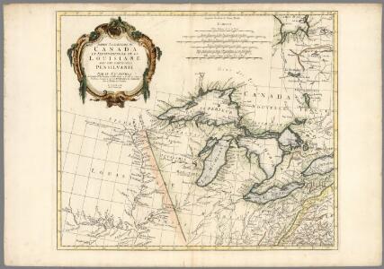
Partie occidentale du Canada et septentrionale de la Louisiane avec une partie de la Pensilvanie
1 : 3000000 Anville, Jean Baptiste Bourguignon d', 1697-1782
(West sheet) Map of the Provinces of Upper & Lower Canada with parts of the United States of America &c.
1 : 2300000 Faden, William, 1750?-1836
Map of the United States of North America / compiled from the latest and most authentic information by David H. Vance ; engraved by J.H. Young.
From Whole
Canada Western.
1 : 5000000 Andree, Richard; Times (London, England)
U.S. West of Mississippi R. 3.
1 : 2000000 Freyhold, Edward; Warren, Gouverneur Kemble, 1830-1882; United States. Army. Corps of Engineers
United States of North America (North East Sheet).
1 : 3984000 Johnston, W. & A.K.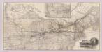
Grand Trunk Ry. of Canada.
1 : 3362700 Grand Trunk Railway Company of Canada
A map of the north west parts of the United States of America
1 : 3000000 Fitch, John, 1743-1798 engraved & printed by the author
County map of Michigan, and Wisconsin.
from Mitchell's new general atlas, containing maps of the various countries of the world, plans of cities, etc., embraced in fifty-three quarto maps., forming a series of eighty four maps and plans, together with valuable statistical tables.
Map of the province of Ontario, dominion of Canada
1 : 2217600 Ontario Department of Lands, Forests & Mines, Bureau of Colonization
134-35. Mich., Wis., Minn., Ia., Mo., Ill., Ind., Ky.
1 : 3000000 Touring club italiano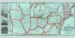
Lake Shore and Michigan So. Railway.
1 : 3431200 Lake Shore & Michigan Southern Railway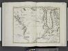
Il paese de' Selvaggi Outagamiani, Mascoutensi, Illinesi, e parte delle VI. Nazioni.
from Le colonie unite dell' America settentrle : di nuova projezione a s.s.e.e. li Signori Riformatori dello Studio di Padova.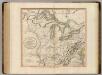
Western Terr., Kentucky, Pennsylvania, etc.
1 : 3300000 Cary, John, ca. 1754-1835
A new and general map of the middle dominions belonging to the United States of America: viz. Virginia, Maryland, the Delaware-counties, Pennsylvania, New Jersey &c. with the addition of New York, & of the greatest part of New England &c as also of the bordering parts of the British possessions in Canada.
from Parts Published by Laurie & Whittle, No. 53 Fleet Street ...: London; Robert Laurie and James Whittle,
Lay's map of the United States / compiled from the latest and best authorities and actual surveys by Amos Lay, geographer and map publisher ; engraved by O.H. & D.S. Throop & Wm. Chapin.
From Whole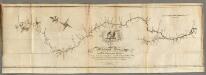
Map of the Mississippi River from its Source to the Mouth of the Missouri.
1 : 1584000 Pike, Zebulon Montgomery
Plan of Captain Carvers Travels in the interior Parts of North America.
1 : 2851200 Carver, Jonathan
Canada, Louisiane et Terres Angloises. (Northwest section)
1 : 2900000 Anville, Jean Baptiste Bourguignon d, 1697-1782
Soil Map of the United States, Section 2. Atlas of American Agriculture.
1 : 2500000 Marbut, Curtis F.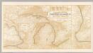
Northern Steamship Co. (map)
1 : 4752000 Northern Steamship Company
Sheet 1: United States of Nth. America.
1 : 1584000 Tardieu, P.F.
Michigan Ter.
1 : 4435200 Lucas, Fielding Jr.
North Western and MichiganTerritories.
1 : 4400000 Lucas, Fielding Jr.
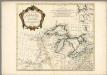
PARTIE OCCIDENTALE de la NOUVELLE FRANCE ou du CANADA
1 : 3600000 Velká kanadská jezera (Kanada a Spojené státy americké) Bellin, Jacques-Nicolas par le Heritiers de Homan
PARTIE OCCIDENTALE de la NOUVELLE FRANCE ou du CANADA
1 : 3600000 Velká kanadská jezera (Kanada a Spojené státy americké) Bellin, Jacques-Nicolas par les Heritiers de Homan
PARTIE OCCIDENTALE de la NOUVELLE FRANCE ou du CANADA
1 : 3600000 Velká kanadská jezera (Kanada a Spojené státy americké) Bellin, Jacques-Nicolas par les Heritiers de Homan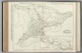
Ontario.
Rand McNally and Company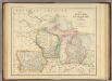
States of Michigan, Wisconsin and Iowa.
1 : 3453120 Rogers, Henry Darwin
Upper Territories of the United States.
1 : 2060000 Carey, Mathew