Maps of Delta County

Maps of Delta County

$title$

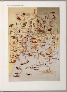
Delta County, Michigan.

Upper Peninsula Development Bureau
$title$

Upper Peninsula, scale six miles to an inch (Delta County)

1 : 380160 Walling, H. F.
$title$

Escanaba

1 : 62500
$title$

Escanaba

1 : 62500
$title$

Peninsula Point

1 : 62500
$title$

Peninsula Point

1 : 62500
$title$

Fairport

1 : 62500
$title$

Fairport

1 : 62500
$title$

Gladstone

1 : 62500
$title$

Rapid River

1 : 62500
$title$

Garden

1 : 62500
$title$

Garden

1 : 62500
$title$

Garden

1 : 62500
$title$

Rock

1 : 62500
$title$

Rock

1 : 62500
$title$

Rock

1 : 62500
$title$

Trenary

1 : 62500
$title$

Trenary

1 : 62500
$title$

Trenary

1 : 62500
$title$

Corner Lake

1 : 62500
$title$

Corner Lake

1 : 62500
$title$

Cedar River

1 : 24000
$title$

Washington Island NW

1 : 24000
$title$

Washington Island NW

1 : 24000
$title$

Washington Island NE

1 : 24000
$title$

Washington Island NE

1 : 24000
$title$

Seagull Point

1 : 24000
$title$

Henderson Lakes

1 : 24000
$title$

Point Detour

1 : 24000
$title$

Fairport

1 : 24000
$title$

Burnt Bluff SW

1 : 31680
© MapTiler © OpenStreetMap contributors
How does it work?
These instructions will show you how to find historical maps online.
Getting started
Type the place name in the search box to find the exact location. You can further adjust the search by zooming in and out.
Zoom
Zoom in and out with the buttons or use your mouse or touchpad natively.
Exact Area tool
Click here and draw a rectangle over the map to precisely define the search area.
Set filters
Narrow your search with advanced settings, such as Years (from/to), Fulltext, Publisher, etc.
Results
See the results of your search on the right side. You can scroll down to find more maps of this location.
?

Download OldMapsOnline Mobile