Maps of Blue Ridge
Sheet 4: United States of Nth. America.
1 : 1584000 Tardieu, P.F.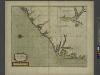
A new mapp of CAROLINA
from The sea-atlas : containing an hydrographical description of most of the sea-coasts of the known parts of the world.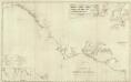
Composite: U.S. coast N.Y. to St. Augustine.
1 : 900000 Blunt, Edmund M. (Edmund March), 1770-1862
Sheet 4: United States of Nth. America.
1 : 1584000 Tardieu, P.F.
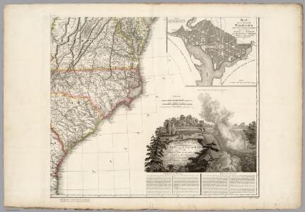
The marches of Lord Cornwallis in the southern provinces, now states of North America, comprehending the two Carolinas, with Virginia and Maryland, and the Delaware counties
1 : 1525000 Faden, William Faden, William
Virginiae item et Floridae Americae provinciarum, nova descriptio.
from Charts and maps Printed by H. Hondius and J. Johnson: [Amsterdam]; Jansson, Jan; Hondius, Jodocus,
Virginiae item et Floridae Americae provinciarum, nova descriptio.
from Parts Ian Ianssen?: [Amsterdam]; Mercator, Gerhard -- Geographer (not in Relator list); Hondius, Jodocus,
Virginiae item et Floridae Americae provinciarum, nova descriptio.
from John H. Levine Collection H. Hondius?: [Amsterdam]; Mercator, Gerhard -- Geographer (not in Relator list); Hondius, Jodocus,
Virginiae item et Floridae Americae provinciarum, nova descriptio.
from Parts Hondius?: [Amsterdam]; Mercator, Gerhard -- Geographer (not in Relator list); Hondius, Jodocus,
County map of North Carolina, Map of South Carolina, County map of Florida ; Map of Charleston Harbor [inset].
from New general atlas.
Nouvelle carte de la Caroline / par R. Morden.; L'Amerique angloise, ou Description des isles et terres du roi d'Angleterre, dans l'Amérique. Avec de nouvelles cartes de chaque isle & terres. Traduit de l'anglois.
from L'Amerique angloise, ou Description des isles et terres du roi d'Angleterre, dans l'Amérique. Avec de nouvelles cartes de chaque isle & terres. Traduit de l'anglois. Blome, Richard,
Virginiae partis australis, et Floridae partis orientalis, interiacentiumque regionum Nova Descriptio. [Karte], in: Novus Atlas, das ist, Weltbeschreibung, Bd. 2, S. 328.
1 Karte aus Atlas Blaeu, Joan Blaeu, Willem Janszoon
Virginiae partis australis, et Floridae partis orientalis, interiacentiumque regionum Nova Descriptio. [Karte], in: Le théâtre du monde, ou, Nouvel atlas contenant les chartes et descriptions de tous les païs de la terre, Bd. 2, S. 321.
1 Karte aus Atlas Blaeu, Willem Janszoon und Blaeu, Joan Blaeu, Willem Janszoon
E. United States 3.
1 : 1774080 Letts, Son & Co.
Carte General De La Caroline. [Karte] [Charles Towne, Flüsse Cooper und Ashley] [Nebenkarte], in: Atlas nouveau, contenant toutes les parties du monde [...], Bd. 2, S. 245.
1 Karte aus Atlas Sanson, Nicolas Jaillot, Alexis Hubert und Mortier, Pieter
Virginiae partis australis, et Floridae partis orientalis, interjacentiumque regionum Nova Descriptio. [Karte], in: Novus atlas absolutissimus, Bd. 6, S. 210.
1 Karte aus Atlas Janssonius Offizin
Maryland, Virginia, North Carolina, and South Carolina.
1 : 3651000 Fisher, Richard Swainson
Virginiae item et Floridae Americae Provinciarum, nova descriptio
Covers coast from Chesapeake to St. Augustine. Relief shown pictorially. Shows Native American settlements throughout North Carolina (named Virginia on the map). Also includes many drawings of ships, animals, sea monsters, and Native Americans. The cartouche includes a view of a Florida Indian village on the left, and a Virginia Indian village on the right. Mercator, Gerhard, 1512-1594.;Hondius, Hendrik, 1597-1651. [Hondius and Johnson]
Virginiae partis australis, et Floridae partis orientalis, interjacentiumque regionum Nova Descriptio. [Karte], in: Theatrum orbis terrarum, sive, Atlas novus, Bd. 2, S. 330.
1 Karte aus Atlas Blaeu, Joan Blaeu, Willem Janszoon
N. & S. Carolina.
1 : 1770000 Society for the Diffusion of Useful Knowledge (Great Britain)
Virginiae item et Floridae Americae Provinciarum, nova descriptio.
The map portrays an area extending from Chesapeake Bay in Virginia to St. Augustine, Florida. Small illustrations of American Indians, local wildlife, ships and sea creatures appear on the map. There is a large rectangular cartouche in the upper left corner with an oval on each side that show differences in the buildings and fortifications between settlements in Florida and Virginia. Captions in lower left and throughout. Mercator, Gerhard, 1512-1594.; Hondius, Hendrik, 1597-1651.
Shell Sectional Map No. 3 - Middle Atlantic States.
1 : 1457280 Shell Oil Company
Virginiae partis australis, et Floridae partis orientalis, interjacentiumq[ue] regionum, nova descriptio.
from John H. Levine Collection Meurs, Jacob van; Montanus, Arnoldus,
Virginiae partis australis, et Floridae partis orientalis, interjacentiumq[ue] regionum nova descriptio.
from Parts J. and C. Blaeu: [Amsterdam]; Blaeu, Joan; Blaeu, Willem Janszoon,
Virginiae partis australis et Floridae partis orientalis interjacentimq[ue] regionum, nova descriptio.
from Charts and maps Ioannem Ianssonium?: [Amstelodami?]; Jansson, Jan,
Virginiae partis australis, et Floridae partis orientalis, interjacentiumq[ue] regionum nova descriptio.
from Parts J. and C. Blaeu: [Amsterdam]; Blaeu, Joan; Blaeu, Willem Janszoon,
Virginiae partis australis, et Floridae partis orientalis, interjacentiumq[ue] regionum nova descriptio.
from John H. Levine Collection J. and C. Blaeu: [Amsterdam]; Blaeu, Joan; Blaeu, Willem Janszoon,
Virginiae partis australis, et Floridae partis orientalis, interjacentiumq[ue] regionum nova descriptio.
from Charts and maps J. and C. Blaeu: [Amsterdam]; Blaeu, Joan; Blaeu, Willem Janszoon,
Virginiae partis australis, et Floridae partis orientalis, interjacentiumq[ue] regionum nova descriptio.
from Parts J. and C. Blaeu: [Amsterdam]; Blaeu, Joan; Blaeu, Willem Janszoon,