Maps of Landkreis Holzminden

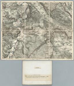
334. Hoxter.
1 : 100000 Reichsamt fur Landesaufnahme
Composite: 334. Hoxter.
1 : 100000 Reichsamt fur Landesaufnahme
Meßtischblatt 2299 : Dassel, 1898
1 : 250000 Dassel. - Aufn. 1896, hrsg. 1898. - 1:25000. - [Berlin]: Reichsamt für Landesaufnahme, 1898. - 1 Kt.
Meßtischblatt 2298 : Stadtoldendorf, 1937
1 : 250000 Stadtoldendorf. - Hrsg. 1898, einz. Nachtr. 1937. - 1:25000. - [Berlin]: Reichsamt für Landesaufnahme, 1937. - 1 Kt.
Meßtischblatt 2298 : Stadtoldendorf, 1898
1 : 250000 Stadtoldendorf. - Aufn. 1896. - 1:25000. - [Berlin]: Reichsamt für Landesaufnahme, 1898. - 1 Kt.
Meßtischblatt 2226, neue Nr. 4024 : Alfeld, 1937
1 : 250000 Alfeld. - Hrsg. 1898, einz. Nachtr. 1937. - 1:25000. - [Berlin]: Reichsamt für Landesaufnahme, 1937. - 1 Kt.
Meßtischblatt 2226, neue Nr. 4024 : Alfeld, 1937
1 : 250000 Alfeld. - Hrsg. 1898, einz. Nachtr. 1937. - 1:25000. - [Berlin]: Reichsamt für Landesaufnahme, 1937. - 1 Kt.
Meßtischblatt 2225 : Eschershausen, 1898
1 : 250000 Eschershausen. - Aufn. 1896. - 1:25000. - [Berlin]: Reichsamt für Landesaufnahme, 1898. - 1 Kt.
Meßtischblatt 2224 : Ottenstein (in Braunschweig), 1897
1 : 250000 Ottenstein (in Braunschweig). - Aufn. 1896. - 1:25000. - [Berlin]: Reichsamt für Landesaufnahme, 1897. - 1 Kt.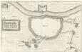
Grundtriß der Statt Höxter, vnd wie selbige von Ihr Exell. Herrn Feld-Marschaln Carol Gustaff Wrangel bezwungen vnd ein genohmen worden 1646
Mollova mapová sbírka Merian, Matthaeus Merian, Matthäus
Meßtischblatt 2373 : Lauenberg, 1919
1 : 250000 Lauenberg. - Aufn. 1896, kleine Nachtr. 1919. - 1:25000. - [Berlin]: Reichsamt für Landesaufnahme, 1919. - 1 Kt.
Meßtischblatt 2372 : Sievershausen, 1924
1 : 250000 Sievershausen. - Hrsg. 1898, einz. Nachtr. 1924. - 1:25000. - [Berlin]: Reichsamt für Landesaufnahme, 1924. - 1 Kt.
Meßtischblatt 2371 : Höxter, 1927
1 : 250000 Höxter. - Aufn. 1896, einz. Nachtr. 1927. - 1:25000. - [Berlin]: Reichsamt für Landesaufnahme, 1927. - 1 Kt.
Meßtischblatt 2371 : Höxter, 1898
1 : 250000 Höxter. - Aufn. 1896. - 1:25000. - [Berlin]: Reichsamt für Landesaufnahme, 1898. - 1 Kt.
99. Göttingen, uit: Topographische Uebersichtskarte des Deutschen Reiches / herausgegeben v. d. Kartogr. Abt. d. Königl. Preuß. Landesaufnahme
1 : 200000 titelvariant: Topogr. Übersichtskarte des Deutschen Reiches; Annotatie: Titel boven bladen ook: Topogr. Übersichtskarte des Deutschen Reiches; Annotatie geografische gegevens: Op elk blad twee maatstokken: 10 Kilometer = 5,5 cm; 1 geogr. Meile = 3,6 cm; Legenda onder op elk blad Königlich Preußische Landesaufnahme. Kartographische Abtheilung [S.l : Königlich Preußische Landesaufnahme, Kartographische Abtheilung]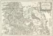
Tableau Topographique Qui comprend la Partie Septentrionale du Landgraviat de Hesse Cassel et de la Principauté de Waldeck, l'Eveché de Paderborn, Partie du Comté de Grubenhague et les Frontieres de ces Etats
1 : 130000 Mollova mapová sbírka Julien, Roch-Joseph Julien, Roch Joseph
Corbeiensis Dioecesis pro ut nunc est, descriptio noua
1 : 60000 Mollova mapová sbírka Gigas, Johann Michael
Corbeiensis Dioecesis pro ut nunc est, descriptio noua
1 : 60000 Mollova mapová sbírka Gigas, Johann Michael
Topographish-petrographische Karte des Fürstenthums Pyrmont und dessen Umgegend
1 : 70000 Dolní Sasko (Německo) Curtze, G. Kirchner, W. Georg Uslar
Die Grafschaft Pyrmont
1 : 50000 Mollova mapová sbírka Overheide, J. A. Homann, Johann Baptista - dědici
Meßtischblatt 2300, neue Nr. 4125 : Einbeck, 1937
1 : 250000 Einbeck. - Hrsg. 1910, einz. Nachtr. 1937. - 1:25000. - [Berlin]: Reichsamt für Landesaufnahme, 1937. - 1 Kt.
Meßtischblatt 2227, neue Nr. 4025 : Gr. Freden, 1937
1 : 250000 Gr. Freden. - Hrsg. 1910, einz. Nachtr. 1937. - 1:25000. - [Berlin]: Reichsamt für Landesaufnahme, 1937. - 1 Kt.
Meßtischblatt 2227 : Gr. Freden, 1927
1 : 250000 Gr. Freden. - Aufn. 1908, einz. Nachtr. 1927. - 1:25000. - [Berlin]: Reichsamt für Landesaufnahme, 1927. - 1 Kt.
Meßtischblatt 2227 : Gr. Freden, 1878
1 : 250000 Gr. Freden. - Aufn. 1876. - 1:25000. - [Berlin]: Reichsamt für Landesaufnahme, 1878. - 1 Kt.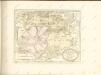

Meßtischblatt 2374, neue Nr. 4225 : Moringen, 1937
1 : 250000 Moringen. - Hrsg. 1910, einz. Nachtr. 1937. - 1:25000. - [Berlin]: Reichsamt für Landesaufnahme, 1937. - 1 Kt.
Meßtischblatt 2374 : Moringen, 1878
1 : 250000 Moringen. - Aufn. 1876. - 1:25000. - [Berlin]: Reichsamt für Landesaufnahme, 1878. - 1 Kt.

Episcopatvs Hildesiensis descriptio novissima
1 : 317000 Hildesheim (Německo) Gigas, Johann Michael Ioanne Gigante
Episcopatvs Hildesiensis descriptio novissima
1 : 320000 Mollova mapová sbírka Gigas, Johann Michael Schenk, Peter I
Episcopatvs Hildesiensis descriptio novissima
1 : 320000 Mollova mapová sbírka Gigas, Johann Michael Janssonius, Johannes I