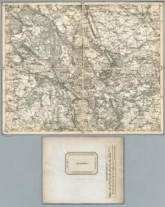
Maps of powiat śremski

325. Schrimm.
1 : 100000 Reichsamt fur Landesaufnahme
Composite: 325. Schrimm.
1 : 100000 Reichsamt fur Landesaufnahme
Meßtischblatt 2200 : Schrimm, 1911
1 : 250000 Schrimm. - Aufn. 1888, hrsg. 1889, bericht. 1911. - 1:25000. - [Berlin]: Reichsamt für Landesaufnahme, 1911. - 1 Kt.
Meßtischblatt 2200 : Schrimm, 1889
1 : 250000 Schrimm. - Aufn. 1888. - 1:25000. - [Berlin]: Reichsamt für Landesaufnahme, 1889. - 1 Kt.
Meßtischblatt 2199 : Dalewo, 1890
1 : 250000 Dalewo. - Aufn. 1888. - 1:25000. - [Berlin]: Reichsamt für Landesaufnahme, 1890. - 1 Kt.
Meßtischblatt 3969 : Xions, 1940?
1 : 250000 Xions. - Aufn. 1888, hrsg. 1890, bericht. 1911, letzte Nachtr. 1932. - 1:25000. - [Berlin]: Reichsamt für Landesaufnahme, [1940?]. - 1 Kt.
Meßtischblatt 2133 : Santomischel, 1890
1 : 250000 Santomischel. - Aufn. 1888. - 1:25000. - [Berlin]: Reichsamt für Landesaufnahme, 1890. - 1 Kt.
Meßtischblatt Brodnica
1 : 250000 Brodnica. - Aufn. 1888, hrsg. 1890, bericht. 1911. - 1:25000. - [Berlin]: Reichsamt für Landesaufnahme, 1911. - 1 Kt.
Meßtischblatt 2134 : Sulencin, 1890
1 : 250000 Sulencin. - Aufn. 1888. - 1:25000. - [Berlin]: Reichsamt für Landesaufnahme, 1890. - 1 Kt.
Meßtischblatt 3767 : Moschin, 1933
1 : 250000 Moschin. - Aufn. 1888, hrsg. 1890, letzte Nachtr. 1933. - 1:25000. - [Berlin]: Reichsamt für Landesaufnahme, 1933. - 1 Kt.
Meßtischblatt 3768 : Kurnik, 1940
1 : 250000 Kurnik. - Aufn. 1888, hrsg. 1890, bericht. 1911, letzte Nachtr. 1932, Ausg. 1940. - 1:25000. - [Berlin]: Reichsamt für Landesaufnahme, 1940. - 1 Kt.
Meßtischblatt 3769 : Schroda, 1936
1 : 250000 Schroda. - Aufn. 1888, hrsg. 1890, bericht. 1911, letzte Nachtr. 1932. - 1:25000. - [Berlin]: Reichsamt für Landesaufnahme, 1936. - 1 Kt.
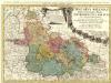
93. Posen, uit: Topographische Uebersichtskarte des Deutschen Reiches / herausgegeben v. d. Kartogr. Abt. d. Königl. Preuß. Landesaufnahme
1 : 200000 titelvariant: Topogr. Übersichtskarte des Deutschen Reiches; Annotatie: Titel boven bladen ook: Topogr. Übersichtskarte des Deutschen Reiches; Annotatie geografische gegevens: Op elk blad twee maatstokken: 10 Kilometer = 5,5 cm; 1 geogr. Meile = 3,6 cm; Legenda onder op elk blad Königlich Preußische Landesaufnahme. Kartographische Abtheilung [S.l : Königlich Preußische Landesaufnahme, Kartographische Abtheilung]
301. Posen.
1 : 100000 Reichsamt fur Landesaufnahme
Composite: 301. Posen.
1 : 100000 Reichsamt fur Landesaufnahme
Kalisch 63, uit: Special-Karte von Mittel-Europa / nach amtlichen Quellen bearbeitet von W. Liebenow
1 : 300000 titelvariant: W. Liebenow's Mittel-Europa; Annotatie: Titel boven de bladen: W. Liebenow's Mittel-Europa Johannes Wilhelm Liebenow 1822-1897 Frankfurt a. M. : Ludwig Ravenstein
324. Kosten.
1 : 100000 Reichsamt fur Landesaufnahme
Meßtischblatt 3966 : Choryn, 1940?
1 : 250000 Choryn. - Aufn. 1890, hrsg. 1892, letzte Nachtr. 1932. - 1:25000. - [Berlin]: Reichsamt für Landesaufnahme, [1940?]. - 1 Kt.
Meßtischblatt 3866 : Czempin, 1940
1 : 250000 Czempin. - Aufn. 1890, hrsg. 1892, letzte Nachtr. 1932. - 1:25000. - [Berlin]: Reichsamt für Landesaufnahme, 1940. - 1 Kt.
Meßtischblatt 3766 : Stenschewo, 1940
1 : 250000 Stenschewo. - Aufn. 1890, hrsg. 1892, bericht. 1911, letzte Nachtr. 1936, Ausg. 1940. - 1:25000. - [Berlin]: Reichsamt für Landesaufnahme, 1940. - 1 Kt.
Basse Silesie Raduitte en deux Feuilles sur celle de 16 Faittes sur les lieux
1 : 408000 Mollova mapová sbírka Le Rouge, Georges-Louis Schubarth, Matthäus
Sect. 16: Posen, uit: Geologische Karte des Deutschen Reichs in 27 Blaettern / [von] Richard Lepsius ; Red. von C. Vogel
1 : 500000 Annotatie: Blad 18 ontbreekt; Een aantal bladen op linnen; Een aantal bladen gereviseerd 1913-1914; Annotatie geografische gegevens: Met schaalstokken o.a. in kilometers; Legenda Carl Vogel 1828-1897 Gotha : Justus Perthes
Silesia Inferior
1 : 870000 Mollova mapová sbírka Scultetus, Johannes Schenk, Peter I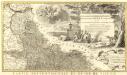
Novissimum Silesiae Theatrum
1 : 400800 Mollova mapová sbírka Condet, Johannes Covens, Johannes I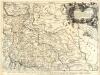
Parte inferiore del Ducato di Silesia
1 : 525000 Mollova mapová sbírka Cantelli, Giacomo De Rossi, Domenico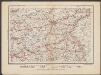
Posen
1 : 600000 Opitz, Carl Solbrig
Dvcatvs Silesiae Tabvla Geographica Prima, Inferiorem eivs partem, seu Novem Principatvs, quorum insignia hic adjecta sunt, secundum statum recentissimum complectens
1 : 575000 Mollova mapová sbírka Hase, Johann Matthias Homann, Johann Baptista - dědici
Monumenta Cartographica Bohemiae II.: Müllerova mapa