Maps of powiat kościański

324. Kosten.
1 : 100000 Reichsamt fur Landesaufnahme
Composite: 324. Kosten.
1 : 100000 Reichsamt fur Landesaufnahme
Meßtischblatt 3965 : Kosten, 1940?
1 : 250000 Kosten. - Aufn. 1890, hrsg. 1892, letzte Nachtr. 1932. - 1:25000. - [Berlin]: Reichsamt für Landesaufnahme, [1940?]. - 1 Kt.
Meßtischblatt 2196 : Poln. Wilke, 1900
1 : 250000 Poln. Wilke. - Aufn. 1890, hrsg. 1892, einzelne Nachtr. 1900. - 1:25000. - [Berlin]: Reichsamt für Landesaufnahme, 1892. - 1 Kt.
Meßtischblatt 3966 : Choryn, 1940?
1 : 250000 Choryn. - Aufn. 1890, hrsg. 1892, letzte Nachtr. 1932. - 1:25000. - [Berlin]: Reichsamt für Landesaufnahme, [1940?]. - 1 Kt.
Meßtischblatt 3865 : Konojad, 1936
1 : 250000 Konojad. - Aufn. 1890, hrsg. 1892, letzte Nachtr. 1933. - 1:25000. - [Berlin]: Reichsamt für Landesaufnahme, 1936. - 1 Kt.
Meßtischblatt 2129 : Wielichowo, 1911
1 : 250000 Wielichowo. - Aufn. 1890, hrsg. 1891, einz. Nachtr. 1911. - 1:25000. - [Berlin]: Reichsamt für Landesaufnahme, 1911. - 1 Kt.
Meßtischblatt 3866 : Czempin, 1940
1 : 250000 Czempin. - Aufn. 1890, hrsg. 1892, letzte Nachtr. 1932. - 1:25000. - [Berlin]: Reichsamt für Landesaufnahme, 1940. - 1 Kt.
Meßtischblatt 3764 : Grätz (Wartheld), 1941
1 : 250000 Grätz (Wartheld.). - Aufn. 1890, hrsg. 1892, bericht. 1941. - 1:25000. - [Berlin]: Reichsamt für Landesaufnahme, 1941. - 1 Kt.
Meßtischblatt 2062 : Granowo, 1892
1 : 250000 Granowo. - Aufn. 1890. - 1:25000. - [Berlin]: Reichsamt für Landesaufnahme, 1892. - 1 Kt.
Meßtischblatt 3766 : Stenschewo, 1940
1 : 250000 Stenschewo. - Aufn. 1890, hrsg. 1892, bericht. 1911, letzte Nachtr. 1936, Ausg. 1940. - 1:25000. - [Berlin]: Reichsamt für Landesaufnahme, 1940. - 1 Kt.
Meßtischblatt 4066 : Storchnest, 1936
1 : 250000 Storchnest. - Aufn. 1890, hrsg. 1892, bericht. 1911, letzte Nachtr. 1932. - 1:25000. - [Berlin]: Reichsamt für Landesaufnahme, 1936. - 1 Kt.
Meßtischblatt 4065 : Leipe, 1940
1 : 250000 Leipe. - Ausg. m. dt. Namen, letzte Nachtr. 1932, vorläuf. Ausg. m. vorläuf. Namensänd. - 1:25000. - [Berlin]: Reichsamt für Landesaufnahme, 1940. - 1 Kt.
Meßtischblatt 2267 : Leipe, 1891
1 : 250000 Leipe. - Aufn. 1890. - 1:25000. - [Berlin]: Reichsamt für Landesaufnahme, 1891. - 1 Kt.
Meßtischblatt 2266 : Luschwitz, 1904
1 : 250000 Luschwitz. - Aufn. 1890, Einzelne Nachtr. 1900, [gedr.] [19]04. - 1:25000. - [Berlin]: Reichsamt für Landesaufnahme, 1904. - 1 Kt.
93. Posen, uit: Topographische Uebersichtskarte des Deutschen Reiches / herausgegeben v. d. Kartogr. Abt. d. Königl. Preuß. Landesaufnahme
1 : 200000 titelvariant: Topogr. Übersichtskarte des Deutschen Reiches; Annotatie: Titel boven bladen ook: Topogr. Übersichtskarte des Deutschen Reiches; Annotatie geografische gegevens: Op elk blad twee maatstokken: 10 Kilometer = 5,5 cm; 1 geogr. Meile = 3,6 cm; Legenda onder op elk blad Königlich Preußische Landesaufnahme. Kartographische Abtheilung [S.l : Königlich Preußische Landesaufnahme, Kartographische Abtheilung]
Meßtischblatt 2195 : Priment, 1893
1 : 250000 Priment. - Aufn. 1891, hrsg. 1893. - 1:25000. - [Berlin]: Reichsamt für Landesaufnahme, 1893. - 1 Kt.
Meßtischblatt 3863, Preuß. 2128 alt : Rakwitz, 1936
1 : 250000 Rakwitz. - Aufn. 1891, letzte Nachtr. 1935/36. - 1:25000. - [Berlin]: Reichsamt für Landesaufnahme, 1936. - 1 Kt.
Meßtischblatt 3763 : Konkolewo, 1941
1 : 250000 Konkolewo. - Aufn. 1891, hrsg. 1893, letzte Nachtr. 1941. - 1:25000. - [Berlin]: Reichsamt für Landesaufnahme, 1941. - 1 Kt.
Meßtischblatt Brodnica
1 : 250000 Brodnica. - Aufn. 1888, hrsg. 1890, bericht. 1911. - 1:25000. - [Berlin]: Reichsamt für Landesaufnahme, 1911. - 1 Kt.
Meßtischblatt 2199 : Dalewo, 1890
1 : 250000 Dalewo. - Aufn. 1888. - 1:25000. - [Berlin]: Reichsamt für Landesaufnahme, 1890. - 1 Kt.
Meßtischblatt 4063 : Weine, 1941
1 : 250000 Weine. - Ausg. m. dt. Namen, letzte Nachtr. 1932, vorläuf. Ausg. m. vorläuf. Namensänd. - 1:25000. - [Berlin]: Reichsamt für Landesaufnahme, 1941. - 1 Kt.
Meßtischblatt 4063 : Weine, 1936
1 : 250000 Weine. - Aufn. 1892, letzte Nachtr. 1922/1933 - 34. - 1:25000. - [Berlin]: Reichsamt für Landesaufnahme, 1936. - 1 Kt.
Meßtischblatt 2265 : Weine, 1919
1 : 250000 Weine. - Aufn. 1892, hrsg. 1894, einzelne Nachtr. 1906, gedr. [19]19. - 1:25000. - [Berlin]: Reichsamt für Landesaufnahme, 1919. - 1 Kt.
Posen 62, uit: Special-Karte von Mittel-Europa / nach amtlichen Quellen bearbeitet von W. Liebenow
1 : 300000 titelvariant: W. Liebenow's Mittel-Europa; Annotatie: Titel boven de bladen: W. Liebenow's Mittel-Europa Johannes Wilhelm Liebenow 1822-1897 Frankfurt a. M. : Ludwig Ravenstein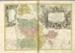
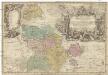
PRINCIPATVS SILESIAE GLOGOVIENSIS novissima Tabula Geographica
1 : 203000 Głogów (Polsko) Wieland, Johann Wolfgang Schubarth, Matthaeus ab Haeredibus Homannianis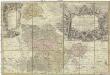
Principatvs Silesiae Glogoviensis novissima tabula geographica sistens 6 ejusdem circulos Glogav, Freystadt, Gvhrav, Sprottav, Grünberg et Schwiebvs, cum districtu Polckwitz nec non liberam dynastiam Bevthen et Carolath
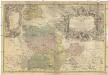
1 : 208000 Głogów (Polsko) Wieland, Johann Wolfgang Schubarth, Matthäus Homannianos Heredes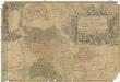
Principatvs Silesiae Glogoviensis novissima tabula geographica sistens 6 ejusdem circulos Glogav, Freystadt, Gvhrav, Sprottav, Grünberg et Schwiebvs, cum districtu Polckwitz nec non liberam dynastiam Bevthen et Carolath
1 : 208000 Głogów (Polsko) Wieland, Johann Wolfgang Schubarth, Matthäus Homannianos Heredes