Maps of gmina Sulechów

322. Zullichau.
1 : 100000 Reichsamt fur Landesaufnahme
322.1. Zullichau.
1 : 100000 Reichsamt fur Landesaufnahme
Composite: 322. Zullichau.
1 : 100000 Reichsamt fur Landesaufnahme
Meßtischblatt 2124 : Kalzig, 1896
1 : 250000 Kalzig. - Aufn. 1894. - 1:25000. - [Berlin]: Reichsamt für Landesaufnahme, 1896. - 1 Kt.
Meßtischblatt 2123 : Skampe, 1896
1 : 250000 Skampe. - Aufn. 1894. - 1:25000. - [Berlin]: Reichsamt für Landesaufnahme, 1896. - 1 Kt.
Meßtischblatt 2125 : Bomst, 1938
1 : 250000 Bomst. - Hrsg. 1896, bericht. 1933, red. Änd. 1938. - 1:25000. - [Berlin]: Reichsamt für Landesaufnahme, 1938. - 1 Kt.
Meßtischblatt 2125 : Bomst, 1933
1 : 250000 Bomst. - Hrsg. 1896, bericht. 1933. - 1:25000. - [Berlin]: Reichsamt für Landesaufnahme, 1933. - 1 Kt.
Meßtischblatt 3959 : Züllichau, 1944
1 : 250000 Züllichau. - Aufn. 1894, hrsg. 1896, bericht. 1944. - 1:25000. - [Berlin]: Reichsamt für Landesaufnahme, 1944. - 1 Kt.
Meßtischblatt 3958 : Rothenburg (Oder), 1938
1 : 250000 Rothenburg (Oder). - Hrsg. 1896, bericht. 1933, redakt. Änd. 1938. - 1:25000. - [Berlin]: Reichsamt für Landesaufnahme, 1938. - 1 Kt.
Meßtischblatt 2192 : Trebschen, 1933
1 : 250000 Trebschen. - Hrsg. 1896, bericht. 1933. - 1:25000. - [Berlin]: Reichsamt für Landesaufnahme, 1933. - 1 Kt.
Meßtischblatt 2192 : Trebschen, 1896
1 : 250000 Trebschen. - Aufn. 1894. - 1:25000. - [Berlin]: Reichsamt für Landesaufnahme, 1896. - 1 Kt.
Meßtischblatt 3759 : Schwiebus, 1944
1 : 250000 Schwiebus. - Aufn. 1894, hrsg. 1896, bericht. 1944. - 1:25000. - [Berlin]: Reichsamt für Landesaufnahme, 1944. - 1 Kt.
Meßtischblatt 3758 : Mühlbock, 1944
1 : 250000 Mühlbock. - Aufn. 1894, hrsg. 1896, bericht. 1944. - 1:25000. - [Berlin]: Reichsamt für Landesaufnahme, 1944. - 1 Kt.
Meßtischblatt 2057 : Stentsch, 1933
1 : 250000 Stentsch. - Hrsg. 1896, bericht. 1933. - 1:25000. - [Berlin]: Reichsamt für Landesaufnahme, 1933. - 1 Kt.
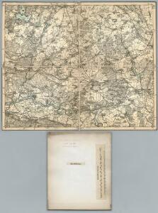
92. Züllichau, uit: Topographische Uebersichtskarte des Deutschen Reiches / herausgegeben v. d. Kartogr. Abt. d. Königl. Preuß. Landesaufnahme
1 : 200000 titelvariant: Topogr. Übersichtskarte des Deutschen Reiches; Annotatie: Titel boven bladen ook: Topogr. Übersichtskarte des Deutschen Reiches; Annotatie geografische gegevens: Op elk blad twee maatstokken: 10 Kilometer = 5,5 cm; 1 geogr. Meile = 3,6 cm; Legenda onder op elk blad Königlich Preußische Landesaufnahme. Kartographische Abtheilung [S.l : Königlich Preußische Landesaufnahme, Kartographische Abtheilung]

Posen 62, uit: Special-Karte von Mittel-Europa / nach amtlichen Quellen bearbeitet von W. Liebenow
1 : 300000 titelvariant: W. Liebenow's Mittel-Europa; Annotatie: Titel boven de bladen: W. Liebenow's Mittel-Europa Johannes Wilhelm Liebenow 1822-1897 Frankfurt a. M. : Ludwig Ravenstein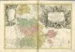

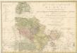
Der Sternbergsche Creis
1 : 292000 Sotzmann, Daniel Friedrich
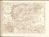
Ducatus Silesiae Glogani


DVCATVS | SILESIÆ | GLOGANI
Vera Delineatio | Secunda curâ ac labore confecta | A Iona Sculteta Sprotta Silesio. [Amsterdam : Joan Blaeu]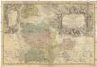
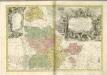
PRINCIPATVS SILESIAE GLOGOVIENSIS novissima Tabula Geographica
1 : 203000 Głogów (Polsko) Wieland, Johann Wolfgang Schubarth, Matthaeus ab Haeredibus Homannianis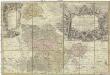
Principatvs Silesiae Glogoviensis novissima tabula geographica sistens 6 ejusdem circulos Glogav, Freystadt, Gvhrav, Sprottav, Grünberg et Schwiebvs, cum districtu Polckwitz nec non liberam dynastiam Bevthen et Carolath
1 : 208000 Głogów (Polsko) Wieland, Johann Wolfgang Schubarth, Matthäus Homannianos Heredes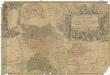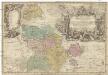
Principatvs Silesiae Glogoviensis novissima tabula geographica sistens VI. ejusdem circulos Glogav, Freystadt, Gvhrav, Sprottav, Grvnberg et Schwiebvs, cum districtu Polckwitz nec non liberam dynastiam Bevthen et Carolath
1 : 200000 Głogów (Polsko) Wieland, Johann Wolfgang Schubarth, Matthäus ab Haeredibus Homannianis
Ducatus Silesiae Glogani vera Delineatio [Karte], in: Gerardi Mercatoris et I. Hondii Newer Atlas, oder, Grosses Weltbuch, Bd. 1, S. 316.
1 Karte aus Atlas Mercator, Gerhard und Hondius, Jodocus Jansson, Jan