Maps of gmina Międzyrzecz

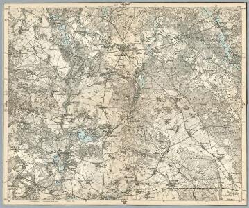
Composite: 298.1. Meseritz.
1 : 100000 Reichsamt fur Landesaufnahme
298.1. Meseritz.
1 : 100000 Reichsamt fur Landesaufnahme
298. Meseritz.
1 : 100000 Reichsamt fur Landesaufnahme
Meßtischblatt 1990 : Brätz, 1896
1 : 250000 Brätz. - Aufn. 1894. - 1:25000. - [Berlin]: Reichsamt für Landesaufnahme, 1896. - 1 Kt.
Meßtischblatt 3659 : Jordan, 1944
1 : 250000 Jordan. - Aufn. 1894, hrsg. 1896, bericht. 1944. - 1:25000. - [Berlin]: Reichsamt für Landesaufnahme, 1944. - 1 Kt.
Meßtischblatt 1922 : Betsche, 1894
1 : 250000 Betsche. - Aufn. 1892. - 1:25000. - [Berlin]: Reichsamt für Landesaufnahme, 1894. - 1 Kt.
Meßtischblatt 3559 : Meseritz, 1944
1 : 250000 Meseritz. - Aufn. 1893, hrsg. 1895, bericht. 1944. - 1:25000. - [Berlin]: Reichsamt für Landesaufnahme, 1944. - 1 Kt.
Meßtischblatt 3658 : Liebenau, 1938
1 : 250000 Liebenau. - Hrsg. 1896, bericht. 1931, einz. Nachtr. 1934, red. Änd. [19]38. - 1:25000. - [Berlin]: Reichsamt für Landesaufnahme, 1938. - 1 Kt.
Meßtischblatt 3558 : Tempel, 1944
1 : 250000 Tempel. - Aufn. 1892, hrsg. 1894, bericht. 1944. - 1:25000. - [Berlin]: Reichsamt für Landesaufnahme, 1944. - 1 Kt.
Meßtischblatt 2057 : Stentsch, 1933
1 : 250000 Stentsch. - Hrsg. 1896, bericht. 1933. - 1:25000. - [Berlin]: Reichsamt für Landesaufnahme, 1933. - 1 Kt.
Meßtischblatt 3759 : Schwiebus, 1944
1 : 250000 Schwiebus. - Aufn. 1894, hrsg. 1896, bericht. 1944. - 1:25000. - [Berlin]: Reichsamt für Landesaufnahme, 1944. - 1 Kt.
Meßtischblatt 3758 : Mühlbock, 1944
1 : 250000 Mühlbock. - Aufn. 1894, hrsg. 1896, bericht. 1944. - 1:25000. - [Berlin]: Reichsamt für Landesaufnahme, 1944. - 1 Kt.
92. Züllichau, uit: Topographische Uebersichtskarte des Deutschen Reiches / herausgegeben v. d. Kartogr. Abt. d. Königl. Preuß. Landesaufnahme
1 : 200000 titelvariant: Topogr. Übersichtskarte des Deutschen Reiches; Annotatie: Titel boven bladen ook: Topogr. Übersichtskarte des Deutschen Reiches; Annotatie geografische gegevens: Op elk blad twee maatstokken: 10 Kilometer = 5,5 cm; 1 geogr. Meile = 3,6 cm; Legenda onder op elk blad Königlich Preußische Landesaufnahme. Kartographische Abtheilung [S.l : Königlich Preußische Landesaufnahme, Kartographische Abtheilung]
Posen 62, uit: Special-Karte von Mittel-Europa / nach amtlichen Quellen bearbeitet von W. Liebenow
1 : 300000 titelvariant: W. Liebenow's Mittel-Europa; Annotatie: Titel boven de bladen: W. Liebenow's Mittel-Europa Johannes Wilhelm Liebenow 1822-1897 Frankfurt a. M. : Ludwig Ravenstein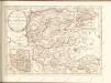

Der Sternbergsche Creis
1 : 292000 Sotzmann, Daniel Friedrich

Ducatus Silesiae Glogani Vera Delineatio [Karte], in: Novus Atlas, das ist, Weltbeschreibung, Bd. 1, S. 182.
1 Karte aus Atlas Blaeu, Joan Blaeu, Willem Janszoon
Marchia nova Vulgo New Marck in March: Brandenburg
1 : 470000 Mollova mapová sbírka Schenk, Pieter Schenk, Peter I
Ducatus Silesiae Glogani Ver Delineatio [Karte], in: Le théâtre du monde, ou, Nouvel atlas contenant les chartes et descriptions de tous les païs de la terre, Bd. 1, S. 213.
1 Karte aus Atlas Blaeu, Willem Janszoon und Blaeu, Joan Blaeu, Willem Janszoon
Ducatus Silesiae Glogani Vera Delineatio [Karte], in: Novus atlas absolutissimus, Bd. 2, S. 258.
1 Karte aus Atlas Janssonius Offizin
Sect. 15: Frankfurt a/O, uit: Geologische Karte des Deutschen Reichs in 27 Blaettern / [von] Richard Lepsius ; Red. von C. Vogel
1 : 500000 Annotatie: Blad 18 ontbreekt; Een aantal bladen op linnen; Een aantal bladen gereviseerd 1913-1914; Annotatie geografische gegevens: Met schaalstokken o.a. in kilometers; Legenda Carl Vogel 1828-1897 Gotha : Justus Perthes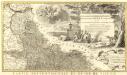
Novissimum Silesiae Theatrum
1 : 400800 Mollova mapová sbírka Condet, Johannes Covens, Johannes I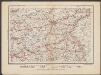
Posen
1 : 600000 Opitz, Carl Solbrig
Wendisch
Deutschland Sorbisch

Lužice

Lužice

Lužica