Maps of Samtgemeinde Mittelweser

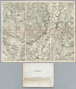
260. Nienburg.
1 : 100000 Reichsamt fur Landesaufnahme
Composite: 260. Nienburg.
1 : 100000 Reichsamt fur Landesaufnahme
Meßtischblatt 1812 : Husum Kr. Nienburg, 1899
1 : 250000 Husum Kr. Nienburg. - Aufn. 1897. - 1:25000. - [Berlin]: Reichsamt für Landesaufnahme, 1899. - 1 Kt.
Meßtischblatt 1811 : Stolzenau, 1899
1 : 250000 Stolzenau. - Aufn. 1897. - 1:25000. - [Berlin]: Reichsamt für Landesaufnahme, 1899. - 1 Kt.
Meßtischblatt 1810 : Nendorf, 1899
1 : 250000 Nendorf. - Aufn. 1897. - 1:25000. - [Berlin]: Reichsamt für Landesaufnahme, 1899. - 1 Kt.
Meßtischblatt 1740 : Nienburg, 1899
1 : 250000 Nienburg. - Aufn. 1897, hrsg. 1899. - 1:25000. - [Berlin]: Reichsamt für Landesaufnahme, 1899. - 1 Kt.
Meßtischblatt 1739 : Liebenau, 1899
1 : 250000 Liebenau. - Aufn. 1897. - 1:25000. - [Berlin]: Reichsamt für Landesaufnahme, 1899. - 1 Kt.
Meßtischblatt 1738 : Siedenburg, 1899
1 : 250000 Siedenburg. - Aufn. 1897. - 1:25000. - [Berlin]: Reichsamt für Landesaufnahme, 1899. - 1 Kt.
Germany 1:25,000, Strohen
Germany 1:25,000 , Series GSGS 4414. Great Britain. War Office. [London] : War Office
Meßtischblatt 1809 : Ströhen, 1938
1 : 250000 Ströhen. - Hrsg. 1899, einz. Nachtr. 1938. - 1:25000. - [Berlin]: Reichsamt für Landesaufnahme, 1938. - 1 Kt.
Meßtischblatt 1737 : Sulingen, 1899
1 : 250000 Sulingen. - Aufn. 1897, hrsg. 1899. - 1:25000. - [Berlin]: Reichsamt für Landesaufnahme, 1899. - 1 Kt.
Delineatio ichnographica Nienburgi ad Visurgim Comitatus Hoyensis metropolis monitissimae Serenissimo Electori Brunsuico-Luneburgensi Subjactae Sumtibus et stilo
1 : 1500 Mollova mapová sbírka Seutter, Matthäus Seutter, Matthäus
Meßtischblatt 1666 : Schwaförden, 1935
1 : 250000 Schwaförden. - Hrsg. 1899, einz. Nachtr. 1925, gedr. [19]35. - 1:25000. - [Berlin]: Reichsamt für Landesaufnahme, 1935. - 1 Kt.
Meßtischblatt 1667 : Bücken. Flecken, 1934
1 : 250000 Bücken Flecken. - Hrsg.1899, einz. Nachtr. 1924, [gedr. 19]34. - 1:25000. - [Berlin]: Reichsamt für Landesaufnahme, 1934. - 1 Kt.
Meßtischblatt 1668 : Eystrup, 1936
1 : 250000 Eystrup. - Hrsg. 1899, einz. Nachtr. 1936. - 1:25000. - [Berlin]: Reichsamt für Landesaufnahme, 1936. - 1 Kt.
Meßtischblatt 1668 : Eystrup, 1899
1 : 250000 Eystrup. - Aufn. 1897. - 1:25000. - [Berlin]: Reichsamt für Landesaufnahme, 1899. - 1 Kt.
Germany 1:25,000, Eystrup
Germany 1:25,000 , Series GSGS 4414. Great Britain. War Office. [London] : War Office
Meßtischblatt 1665 : Schmalförden, 1936
1 : 250000 Schmalförden. - Hrsg. 1899, einz. Nachtr. 1924, gedr. [19]36. - 1:25000. - [Berlin]: Reichsamt für Landesaufnahme, 1936. - 1 Kt.
Germany/Central Europe 1:100,000, Minden
Germany / Central Europe 1:100,000, Series GSGS 4416. Great Britain. War Office. [London] : Ordnance Survey
72. Nienburg, uit: Topographische Uebersichtskarte des Deutschen Reiches / herausgegeben v. d. Kartogr. Abt. d. Königl. Preuß. Landesaufnahme
1 : 200000 titelvariant: Topogr. Übersichtskarte des Deutschen Reiches; Annotatie: Titel boven bladen ook: Topogr. Übersichtskarte des Deutschen Reiches; Annotatie geografische gegevens: Op elk blad twee maatstokken: 10 Kilometer = 5,5 cm; 1 geogr. Meile = 3,6 cm; Legenda onder op elk blad Königlich Preußische Landesaufnahme. Kartographische Abtheilung [S.l : Königlich Preußische Landesaufnahme, Kartographische Abtheilung]
259. Diepholz.
1 : 100000 Reichsamt fur Landesaufnahme
Composite: 259. Diepholz.
1 : 100000 Reichsamt fur Landesaufnahme
Meßtischblatt 1883 : Rehburg, 1937
1 : 250000 Rehburg. - Hrsg. 1897, einz. Nachtr. 1924, gedr. [19]37. - 1:25000. - [Berlin]: Reichsamt für Landesaufnahme, 1937. - 1 Kt.
Meßtischblatt 1882 : Schlüsselburg, 1938
1 : 250000 Schlüsselburg. - Hrsg. 1897, einz. Nachtr. 1938. - 1:25000. - [Berlin]: Reichsamt für Landesaufnahme, 1938. - 1 Kt.
Meßtischblatt 1881 : Uchte, 1937
1 : 250000 Uchte. - Aufn. 1896, Nachtr. 1919, gedr. [19]37. - 1:25000. - [Berlin]: Reichsamt für Landesaufnahme, 1937. - 1 Kt.
Carte topographique d'Allemagne
1 : 225000 Brémy (Německo) Jaeger, Johann Wilhelm Abraham Berndt, Johann Christoph I.W.A. Iaeger

85. Minden, uit: Topographische Uebersichtskarte des Deutschen Reiches / herausgegeben v. d. Kartogr. Abt. d. Königl. Preuß. Landesaufnahme
1 : 200000 titelvariant: Topogr. Übersichtskarte des Deutschen Reiches; Annotatie: Titel boven bladen ook: Topogr. Übersichtskarte des Deutschen Reiches; Annotatie geografische gegevens: Op elk blad twee maatstokken: 10 Kilometer = 5,5 cm; 1 geogr. Meile = 3,6 cm; Legenda onder op elk blad Königlich Preußische Landesaufnahme. Kartographische Abtheilung [S.l : Königlich Preußische Landesaufnahme, Kartographische Abtheilung]
Minden 57, uit: Special-Karte von Mittel-Europa / nach amtlichen Quellen bearbeitet von W. Liebenow
1 : 300000 titelvariant: W. Liebenow's Mittel-Europa; Annotatie: Titel boven de bladen: W. Liebenow's Mittel-Europa Johannes Wilhelm Liebenow 1822-1897 Frankfurt a. M. : Ludwig Ravenstein