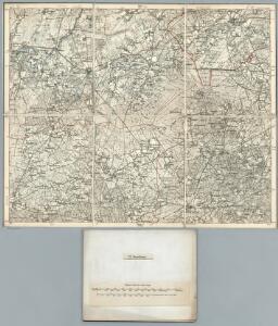
Maps of Samtgemeinde Herzlake

257. Haselunne.
1 : 100000 Reichsamt fur Landesaufnahme
Composite: 257. Haselunne.
1 : 100000 Reichsamt fur Landesaufnahme
Meßtischblatt 1802 : Lengerich in Hannover, 1900
1 : 250000 Lengerich in Hannover. - Aufn. 1898. - 1:25000. - [Berlin]: Reichsamt für Landesaufnahme, 1900. - 1 Kt.
Meßtischblatt 1801 : Backum, 1934
1 : 250000 Backum. - Hrsg. 1900, einz. Nachtr. 1910, [gedr. 19]34. - 1:25000. - [Berlin]: Reichsamt für Landesaufnahme, 1934. - 1 Kt.
Meßtischblatt 1730 : Herzlake, 1900
1 : 250000 Herzlake. - Aufn. 1898, hrsg. 1900. - 1:25000. - [Berlin]: Reichsamt für Landesaufnahme, 1900. - 1 Kt.
Meßtischblatt 1729 : Haselünne, 1900
1 : 250000 Haselünne. - Aufn. 1898, hrsg. 1900. - 1:25000. - [Berlin]: Reichsamt für Landesaufnahme, 1900. - 1 Kt.
Meßtischblatt 1658 : Holte, 1900
1 : 250000 Holte. - Aufn. 1898. - 1:25000. - [Berlin]: Reichsamt für Landesaufnahme, 1900. - 1 Kt.
Meßtischblatt 1800 : Lingen, 1898
1 : 250000 Lingen. - Aufn. 1896. - 1:25000. - [Berlin]: Reichsamt für Landesaufnahme, 1898. - 1 Kt.
Meßtischblatt 1728 : Meppen, 1925
1 : 250000 Meppen. - Aufn. 1896, einz. Nachtr. 1925. - 1:25000. - [Berlin]: Reichsamt für Landesaufnahme, 1925. - 1 Kt.
Meßtischblatt 1728 : Meppen, 1897
1 : 250000 Meppen. - Aufn. 1896, hrsg. 1897. - 1:25000. - [Berlin]: Reichsamt für Landesaufnahme, 1897. - 1 Kt.
Meßtischblatt 1656 : Haren, 1934
1 : 250000 Haren. - Hrsg. 1898, einz. Nachtr. 1913, gedr. [19]34. - 1:25000. - [Berlin]: Reichsamt für Landesaufnahme, 1934. - 1 Kt.
LINGÆ OBSIDIO | Confecta ab Il.mi Principe | MAVRITIO NASSOVIO, etc. | Armis Ordd. Belgicæ Foederatæ Ao. 1605.
[Amsterdam : Joan Blaeu]
LINGA OBSESSA et EXPVGNATA | Per AMBROSIVM SPINOLAM VENAFRI Marchionem, | Capitaneum generalem Archiducum Austriæ, | ALBERTI et ISABELLÆ, Brabantiæ Ducum etc. An. 1605
[Amsterdam : Joan Blaeu]
LINGHEN : [fortification plan].
[Amsterdam : Joan Blaeu]
Meßtischblatt 1803 : Fürstenau in Hannover, 1900
1 : 250000 Fürstenau in Hannover. - Aufn. 1898. - 1:25000. - [Berlin]: Reichsamt für Landesaufnahme, 1900. - 1 Kt.
Meßtischblatt 1731 : Berge, 1900
1 : 250000 Berge. - Aufn. 1898. - 1:25000. - [Berlin]: Reichsamt für Landesaufnahme, 1900. - 1 Kt.
Meßtischblatt 1659 : Löningen, 1900
1 : 250000 Löningen. - Aufn. 1898, hrsg. 1900. - 1:25000. - [Berlin]: Reichsamt für Landesaufnahme, 1900. - 1 Kt.
71. Cloppenburg, uit: Topographische Uebersichtskarte des Deutschen Reiches / herausgegeben v. d. Kartogr. Abt. d. Königl. Preuß. Landesaufnahme
1 : 200000 titelvariant: Topogr. Übersichtskarte des Deutschen Reiches; Annotatie: Titel boven bladen ook: Topogr. Übersichtskarte des Deutschen Reiches; Annotatie geografische gegevens: Op elk blad twee maatstokken: 10 Kilometer = 5,5 cm; 1 geogr. Meile = 3,6 cm; Legenda onder op elk blad Königlich Preußische Landesaufnahme. Kartographische Abtheilung [S.l : Königlich Preußische Landesaufnahme, Kartographische Abtheilung]
Composite: 256. Lingen.
1 : 100000 Reichsamt fur Landesaufnahme
256. Lingen.
1 : 100000 Reichsamt fur Landesaufnahme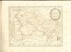

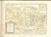
Episcopatvs Monasteriensis Pars Septentrionalis
1 : 290000 Mollova mapová sbírka Gigas, Johann Michael
Episcopatvs Monasteriensis Pars Septentrionalis
1 : 290000 Mollova mapová sbírka Gigas, Johann Michael
Carte topographique d'Allemagne
1 : 214500 Friesland (Německo) Jaeger, Johann Wilhelm Abraham I.W.A. Iaeger
L'Eveché de Munster Le Comté de Bentheim Tecklenbourg Stenford Lingen, Diepholtz Delmenhorst, Ritberg &c.
1 : 420000 Mollova mapová sbírka Le Rouge, Georges-Louis Le Rouge, Georges-Louis
Basse Partie de l'Evesché de Munster, et le Comté de Benthem
1 : 300000 Mollova mapová sbírka Sanson, Guillaume Mortier, Pierre
Rev.mo et Seren.mo Principi ac Domo. Dn. Ferdinando Archiep. et Elect. Colon. Episcop. Monasteriens Leto, Duci Bavariae
Mollova mapová sbírka Gigas, Johann Michael
1:250 000 Europe
1 : 250000 Osnabrück (Německo) War Office
Monasteriensis et Osnabvrgensis Episcopatvs
1 : 490000 Mollova mapová sbírka Maschop, Gottfried