Maps of gmina Żnin

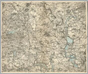
Composite: 252. Exin.
1 : 100000 Reichsamt fur Landesaufnahme
252. Exin.
1 : 100000 Reichsamt fur Landesaufnahme
Meßtischblatt 3171 : Elsenau, 1936
1 : 250000 Elsenau. - Aufn. 1888, letzte Nachtr. 1934/35. - 1:25000. - [Berlin]: Reichsamt für Landesaufnahme, 1936. - 1 Kt.
Meßtischblatt 1647 : Stempuchowo, 1889
1 : 250000 Stempuchowo. - Aufn. 1888. - 1:25000. - [Berlin]: Reichsamt für Landesaufnahme, 1889. - 1 Kt.
Meßtischblatt 3071 : Lindenbrück, 1940
1 : 250000 Lindenbrück. - Ausg. m. dt. Namen, Ausg. 1940 m. vorläuf. Namen. - 1:25000. - [Berlin]: Reichsamt für Landesaufnahme, 1940. - 1 Kt.
Meßtischblatt 3070 : Exin, 1936
1 : 250000 Exin. - Aufn. 1888, hrsg. 1889, letzte Nachtr. 1934/35. - 1:25000. - [Berlin]: Reichsamt für Landesaufnahme, 1936. - 1 Kt.
Meßtischblatt 3172 : Znin, 1940
1 : 250000 Znin. - Aufn. 1888, hrsg. 1889, bericht. 1911, letzte Nachtr. 1933, Ausg. 1940. - 1:25000. - [Berlin]: Reichsamt für Landesaufnahme, 1940. - 1 Kt.
Meßtischblatt 3072 : Grünhagen, 1940
1 : 250000 Grünhagen. - Ausg. m. dt. Namen, Ausg. 1940 m. vorläuf. Namen. - 1:25000. - [Berlin]: Reichsamt für Landesaufnahme, 1940. - 1 Kt.
Meßtischblatt 3072, Preuß. alt 1578 : Grünhagen, 1935
1 : 250000 Grünhagen. - Aufn. 1888, letzte Nachtr. 1934/35. - 1:25000. - [Berlin]: Reichsamt für Landesaufnahme, 1935. - 1 Kt.
Meßtischblatt 1718 : Rogowo, 1889
1 : 250000 Rogowo. - Aufn. 1888. - 1:25000. - [Berlin]: Reichsamt für Landesaufnahme, 1889. - 1 Kt.
Meßtischblatt 3270 : Janowitz, 1936
1 : 250000 Janowitz. - Aufn. 1888, letzte Nachtr. 1934/35. - 1:25000. - [Berlin]: Reichsamt für Landesaufnahme, 1936. - 1 Kt.
Meßtischblatt 3272 : Gonsawa, 1936
1 : 250000 Gonsawa. - Aufn. 1888, letzte Nachtr. 1934/35. - 1:25000. - [Berlin]: Reichsamt für Landesaufnahme, 1936. - 1 Kt.
81. Gnesen, uit: Topographische Uebersichtskarte des Deutschen Reiches / herausgegeben v. d. Kartogr. Abt. d. Königl. Preuß. Landesaufnahme
1 : 200000 titelvariant: Topogr. Übersichtskarte des Deutschen Reiches; Annotatie: Titel boven bladen ook: Topogr. Übersichtskarte des Deutschen Reiches; Annotatie geografische gegevens: Op elk blad twee maatstokken: 10 Kilometer = 5,5 cm; 1 geogr. Meile = 3,6 cm; Legenda onder op elk blad Königlich Preußische Landesaufnahme. Kartographische Abtheilung [S.l : Königlich Preußische Landesaufnahme, Kartographische Abtheilung]
251. Wongrowitz.
1 : 100000 Reichsamt fur Landesaufnahme
272. Landsberg a. d. Warthe.
1 : 100000 Reichsamt fur Landesaufnahme
Composite: 251. Wongrowitz.
1 : 100000 Reichsamt fur Landesaufnahme
Meßtischblatt 2970 : Gromaden, 1940
1 : 250000 Gromaden. - Aufn. 1876, hrsg. 1878, letzte Nachtr. 1935. - 1:25000. - [Berlin]: Reichsamt für Landesaufnahme, 1940. - 1 Kt.
Meßtischblatt 2971 : Szaradowo, 1940
1 : 250000 Szaradowo. - Aufn. 1876, hrsg. 1878. - 1:25000. - [Berlin]: Reichsamt für Landesaufnahme, 1940. - 1 Kt. Auch als Nachdr. ersch. - Nadelabw. für Mitte 1936
Meßtischblatt 2972 : Schubin, 1940
1 : 250000 Schubin. - Aufn. 1876, hrsg. 1878, letzte Nachtr. 1935. - 1:25000. - [Berlin]: Reichsamt für Landesaufnahme, 1940. - 1 Kt.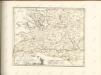

Sect. 10: Bromberg, uit: Geologische Karte des Deutschen Reichs in 27 Blaettern / [von] Richard Lepsius ; Red. von C. Vogel
1 : 500000 Annotatie: Blad 18 ontbreekt; Een aantal bladen op linnen; Een aantal bladen gereviseerd 1913-1914; Annotatie geografische gegevens: Met schaalstokken o.a. in kilometers; Legenda Carl Vogel 1828-1897 Gotha : Justus Perthes
Bromberg
1 : 600000 Opitz, Carl Solbrig
Monumenta Cartographica Bohemiae II.: Müllerova mapa

Provinz Posen
1 : 1200000 Provinz Posen
Posen.
1 : 810000 Radefeld, Carl Christian Franz, 1788-1874
Palatinatus Posnaniensis. In Majori Polonia Primarii Nova Delinatio [Karte], in: Novus atlas absolutissimus, Bd. 1, S. 96.
1 Karte aus Atlas Janssonius Offizin
Provinz Posen
Grosser Hand-Atlas über alle Theile der Erde in 170 Karten Meyer, J. Verlag des Bibliographischen Instituts
SILESIA | INFERIOR
Noviter et accurata delineata | á Jona Sculteto Sprotta Silesio. [Amsterdam : Joan Blaeu]