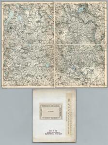
Maps of gmina Lubiszyn

247. Soldin.
1 : 100000 Reichsamt fur Landesaufnahme
247.1. Soldin.
1 : 100000 Reichsamt fur Landesaufnahme
Composite: 247. Soldin.
1 : 100000 Reichsamt fur Landesaufnahme
Meßtischblatt 3157 : Lotzen, 1934
1 : 250000 Lotzen. - Hrsg. 1893, bericht. 1934. - 1:25000. - [Berlin]: Reichsamt für Landesaufnahme, 1934. - 1 Kt.
Meßtischblatt 1633 : Gr. Fahlenwerder, 1893
1 : 250000 Gr. Fahlenwerder. - Aufn. 1891. - 1:25000. - [Berlin]: Reichsamt für Landesaufnahme, 1893. - 1 Kt.
Meßtischblatt 1632 : Staffelde, 1893
1 : 250000 Staffelde. - Aufn. 1891. - 1:25000. - [Berlin]: Reichsamt für Landesaufnahme, 1893. - 1 Kt.
Meßtischblatt 1561 : Soldin, 1934
1 : 250000 Soldin. - Hrsg. 1891, bericht. 1934. - 1:25000. - [Berlin]: Reichsamt für Landesaufnahme, 1934. - 1 Kt.
Meßtischblatt 1561 : Soldin, 1930
1 : 250000 Soldin. - Hrsg. 1891, einz. Nachtr. 1930. - 1:25000. - [Berlin]: Reichsamt für Landesaufnahme, 1930. - 1 Kt.
Meßtischblatt 1561 : Soldin, 1891
1 : 250000 Soldin. - Aufn. 1890. - 1:25000. - [Berlin]: Reichsamt für Landesaufnahme, 1891. - 1 Kt.
Meßtischblatt 1562 : Karzig, 1891
1 : 250000 Karzig. - Aufn. 1890. - 1:25000. - [Berlin]: Reichsamt für Landesaufnahme, 1891. - 1 Kt.
Meßtischblatt 1563 : Berlinchen, 1934
1 : 250000 Berlinchen. - Hrsg. 1892, bericht. 1934. - 1:25000. - [Berlin]: Reichsamt für Landesaufnahme, 1934. - 1 Kt.
Meßtischblatt 1704 : Landsberg an der Warthe, 1934
1 : 250000 Landsberg an der Warthe. - Hrsg. 1893, bericht. 1934. - 1:25000. - [Berlin]: Reichsamt für Landesaufnahme, 1934. - 1 Kt.
Meßtischblatt 1703 : Hohenwalde, 1934
1 : 250000 Hohenwalde. - Hrsg. 1893, bericht. 1934. - 1:25000. - [Berlin]: Reichsamt für Landesaufnahme, 1934. - 1 Kt.
Meßtischblatt 3255 : Massin, 1936
1 : 250000 Massin. - Aufn. 1891, hrsg. 1893, bericht. 1934. - 1:25000. - [Berlin]: Reichsamt für Landesaufnahme, 1936. - 1 Kt.
Meßtischblatt 1702 : Massin, 1913
1 : 250000 Massin. - Aufn. 1891, hrsg. 1893, Aufldr. 1913. - 1:25000. - [Berlin]: Reichsamt für Landesaufnahme, 1913. - 1 Kt.
78. Küstrin, uit: Topographische Uebersichtskarte des Deutschen Reiches / herausgegeben v. d. Kartogr. Abt. d. Königl. Preuß. Landesaufnahme
1 : 200000 titelvariant: Topogr. Übersichtskarte des Deutschen Reiches; Annotatie: Titel boven bladen ook: Topogr. Übersichtskarte des Deutschen Reiches; Annotatie geografische gegevens: Op elk blad twee maatstokken: 10 Kilometer = 5,5 cm; 1 geogr. Meile = 3,6 cm; Legenda onder op elk blad Königlich Preußische Landesaufnahme. Kartographische Abtheilung [S.l : Königlich Preußische Landesaufnahme, Kartographische Abtheilung]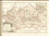

Küstrin 48, uit: Special-Karte von Mittel-Europa / nach amtlichen Quellen bearbeitet von W. Liebenow
1 : 300000 titelvariant: W. Liebenow's Mittel-Europa; Annotatie: Titel boven de bladen: W. Liebenow's Mittel-Europa Johannes Wilhelm Liebenow 1822-1897 Frankfurt a. M. : Ludwig Ravenstein
Abbildung der sehr grossen und blutigen Feldschlacht, welche am 25. August 1758 bei Zorndorf, ohnweit Cüstrin, zwischen der König. Preussischen Armée, unter Se. Königl. Maj. Höchsteigener Anführung, und der Russischen, unter Commando des Generals von Fermor, vorgefallen. bei welcher Se. König. Maj. abermal einen vollkommenen Sieg erfochten, ohnerachtet der grossen Überlegenheit der Feinde, sowol an Mannschaft als Geschütze, und der vorteilhaften Stellung, welche sie zwischen Wäldern und Morästen genommen

Der Soldinsche Creis
1 : 296000 Myślibórz (Polsko) Sotzmann, Daniel Friedrich Glassbach, Carl Christian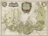
Marchionatus Brandenburgici Partes Duae Nova Marchia et Uckerana
1 : 420000 Mollova mapová sbírka Örnehufvud, Olof Hansson Covens, Johannes I
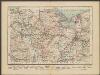
272.1. Landsberg a. d. W.
1 : 100000 Reichsamt fur Landesaufnahme
Meßtischblatt 1631 : Rosenthal in der Mark, 1927
1 : 250000 Rosenthal in der Mark. - Aufn. 1891, einz. Nachtr. 1927. - 1:25000. - [Berlin]: Reichsamt für Landesaufnahme, 1927. - 1 Kt.
Meßtischblatt 1560 : Schildberg bei Soldin, 1930
1 : 250000 Schildberg bei Soldin. - Hrsg. 1893, einz. Nachtr. 1930. - 1:25000. - [Berlin]: Reichsamt für Landesaufnahme, 1930. - 1 Kt.
Marchia nova Vulgo New Marck in March: Brandenburg
1 : 470000 Mollova mapová sbírka Schenk, Pieter Schenk, Peter I
MARCHIONATUS | BRANDENBURGICI | PARTES DUÆ, | NOVA MARCHIA | et | UCKERANA
Auctore | OLAO JOANNIS GOTHO | Gustaui Magni Cosmographo. [Amsterdam : Joan Blaeu]
Mapa Wojewodztwa Szczecinskiego
Stettin
1 : 600000 Opitz, Carl Solbrig