Maps of Löwenberger Land

243. Oranienburg.
1 : 100000 Reichsamt fur Landesaufnahme
Composite: 243. Oranienburg.
1 : 100000 Reichsamt fur Landesaufnahme
Messtischblatt 1621, neue Nr. 3144 : Beetz, 1938 Beetz
1 : 250000 Beetz. - Hrsg. 1883, einz. Nachtr. 1926, red. Änd. 7.38. - 1:25000. - [Berlin]: Reichsamt für Landesaufnahme, 1938. - 1 Kt.
Meßtischblatt, 1621 : Beetz, 1909
1 : 250000 Beetz. - Aufn. 1881, hrsg. 1883, einz. Nachtr. 1909. - 1:25000. - [Berlin]: Reichsamt für Landesaufnahme, 1909. - 1 Kt.
Messtischblatt 3143 : Wustrau, 1934 Wustrau
1 : 250000 Wustrau. - Hrsg. 1883, einz. Nachtr. 1932, gedr. [19]34. - 1:25000. - [Berlin]: Reichsamt für Landesaufnahme, 1934. - 1 Kt.
Meßtischblatt 1620 : Wustrau, 1909
1 : 250000 Wustrau. - Aufn. 1881, hrsg. 1883, einz. Nachtr. 1899, gedr. [1]909. - 1:25000. - [Berlin]: Reichsamt für Landesaufnahme, 1909. - 1 Kt.
Meßtischblatt 3044 : Gr. Mutz, 1951
1 : 250000 Gr. Mutz. - Hrsg. 1881, letzte Nachtr. 1936. - 1:25000. - [Berlin], 1951. - 1 Kt.
Meßtischblatt Gr. Mutz
1 : 250000 Gr. Mutz. - Hrsg. 1883, einz. Nachtr. 1936. - 1:25000. - [Berlin]: Reichsamt für Landesaufnahme, 1945. - 1 Kt.
Meßtischblatt 3043 : Lindow, 1932
1 : 250000 Lindow. - Hrsg. 1883. - 1:25000. - [Berlin]: Reichsamt für Landesaufnahme, 1932. - 1 Kt.
Meßtischblatt 1549 : Lindow, 1906
1 : 250000 Lindow. - Aufn. 1881, hrsg. 1883, einzelne Nachtr. 1903, gedr. [19]06. - 1:25000. - [Berlin]: Reichsamt für Landesaufnahme, 1906. - 1 Kt.
Messtischblatt 3145 : Nassenheide, 1942 Nassenheide
1 : 250000 Nassenheide. - Aufn. 1881, hrsg. 1883, ber. 1940, Ausg. 1940. - 1:25000. - [Berlin]: Reichsamt für Landesaufnahme, 1942. - 1 Kt.
Le cercle de Glien et de Loewenberg dans la Marche-Moyenne de Brandenbourg
1 : 296000 Braniborsko (Německo) Oesfeld, Karl Ludwig von
Meßtischblatt 3244 : Kremmen, 1941
1 : 250000 Kremmen. - Aufn. 1901, hrsg. 1903, bericht. 1919, letzte Nachtr. 1940. - 1:25000. - [Berlin]: Reichsamt für Landesaufnahme, 1941. - 1 Kt.
Meßtischblatt 1691 : Kremmen, 1917
1 : 250000 Kremmen. - Aufn. 1901, hrsg. 1903, Aufldr. 1917. - 1:25000. - [Berlin]: Reichsamt für Landesaufnahme, 1917. - 1 Kt.
Meßtischblatt 3243 : Linum, 1942
1 : 250000 Linum. - [Hrsg. 1903, bericht. 1919, letzte Nachtr. 1940]. - 1:25000. - [Berlin]: Reichsamt für Landesaufnahme, [1942]. - 1 Kt.
76. Charlottenburg, uit: Topographische Uebersichtskarte des Deutschen Reiches / herausgegeben v. d. Kartogr. Abt. d. Königl. Preuß. Landesaufnahme
1 : 200000 titelvariant: Topogr. Übersichtskarte des Deutschen Reiches; Annotatie: Titel boven bladen ook: Topogr. Übersichtskarte des Deutschen Reiches; Annotatie geografische gegevens: Op elk blad twee maatstokken: 10 Kilometer = 5,5 cm; 1 geogr. Meile = 3,6 cm; Legenda onder op elk blad Königlich Preußische Landesaufnahme. Kartographische Abtheilung [S.l : Königlich Preußische Landesaufnahme, Kartographische Abtheilung]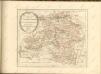

Ruppin 47, uit: Special-Karte von Mittel-Europa / nach amtlichen Quellen bearbeitet von W. Liebenow
1 : 300000 titelvariant: W. Liebenow's Mittel-Europa; Annotatie: Titel boven de bladen: W. Liebenow's Mittel-Europa Johannes Wilhelm Liebenow 1822-1897 Frankfurt a. M. : Ludwig Ravenstein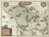
Marchionatvs Brandenburgici
1 : 330000 Mollova mapová sbírka Örnehufvud, Olof Hansson Covens, Johannes I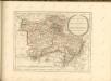

Der Nieder-Barnimsche Creis
1 : 302000 Braniborsko (Německo) Oesfeld, Karl Ludwig von Glassbach, Carl Christian
Blatt I Nauen, uit: Karte von Berlin und Umgebung in 12 Blättern
1 : 50000 Annotatie: Toelichtingen opgeborgen bij kaart; Annotatie geografische gegevens: Met schaalstokken: Meter, Schritt, geographische Meile Paul Schneider Berlin : Reichsamt für Landesaufnahme
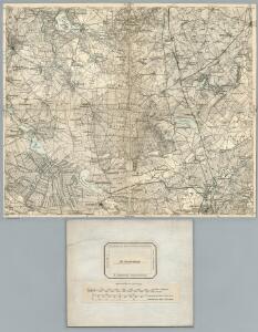
Meßtischblatt 3245 : Oranienburg, 1939
1 : 250000 Oranienburg. - Aufn. 1901, hrsg. 1903, bericht. 1938. - 1:25000. - [Berlin]: Reichsamt für Landesaufnahme, 1939. - 1 Kt.
Meßtischblatt 1692 : Oranienburg, 1927
1 : 250000 Oranienburg. - Aufn. 1901, bericht. 1919, einz. Nachtr. 1927. - 1:25000. - [Berlin]: Reichsamt für Landesaufnahme, 1927. - 1 Kt.
Meßtischblatt 1692 : Oranienburg, 1913
1 : 250000 Oranienburg. - Aufn. 1901, hrsg. 1903, Aufldr. 1913. - 1:25000. - [Berlin]: Reichsamt für Landesaufnahme, 1913. - 1 Kt.
MARCHIONATUS | BRANDENBURGICI | PARTES DUÆ, | RUPPIN | Comitatus | & | PRIGNITS | Regiuncula
Auct. Olao Iohannis Gotho, Gustavo Magno Cosm. [Amsterdam : Joan Blaeu]
MARCH. BRANDENBURGICI | PARS, quæ | MARCHIA MEDIA | Vulgo MITTELMARCK audit.
Amstelædami, | Excud. Joannes Blaeu.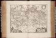
March. Brandenburgici pars, quae Marchia Media vulgo Mittelmarck audit
1 : 400000 Annotatie: Origineel is Blad 91 in atlas factice; Annotatie geografische gegevens: Met schaalstok: Milliaria Germanica Joan Blaeu 1597/98-1673 Amstelaedami : excud. Joannes Blaeu
Berlin - Leipzig - Wittenberge

Marchia Media Vulgo Mittel Marck in March: Brandenb:
1 : 500000 Mollova mapová sbírka Valk, Gerhard Schenk, Peter I