Maps of gmina Lubowidz

228. Gurzno.
1 : 100000 Reichsamt fur Landesaufnahme
Meßtischblatt 2883 : Gorzno, 1940
1 : 250000 Gorzno. - Aufn. 1909, letzte Nachtr. 1938. - 1:25000. - [Berlin]: Reichsamt für Landesaufnahme, 1940. - 1 Kt.
Meßtischblatt 2884 : Adl. Brinsk, 1940
1 : 250000 Adl. Brinsk. - Aufn. 1909, hrsg. 1910, letzte Nachtr. 1929/30. - 1:25000. - [Berlin]: Reichsamt für Landesaufnahme, 1940. - 1 Kt.
Meßtischblatt 2882 : Wilhelmsdank, 1941
1 : 250000 Wilhelmsdank. - Aufn. 1909, hrsg. 1910, letzte Nachtr. 1929. - 1:25000. - [Berlin]: Reichsamt für Landesaufnahme, 1941. - 1 Kt.
Meßtischblatt 2783 : Radosk, 1930
1 : 250000 Radosk. - Aufn. 1909, letzte Nachtr. 1928/30. - 1:25000. - [Berlin]: Reichsamt für Landesaufnahme, 1930. - 1 Kt.
Meßtischblatt 2784 : Lautenburg, 1940
1 : 250000 Lautenburg. - Aufn. 1909, letzte Nachtr. 1928/30. - 1:25000. - [Berlin]: Reichsamt für Landesaufnahme, 1940. - 1 Kt.
Meßtischblatt 2782 : Strasburg i. Westpr., 1940
1 : 250000 Strasburg i. Westpr. - Aufn. 1909, letzte Nachtr. 1928/30. - 1:25000. - [Berlin]: Reichsamt für Landesaufnahme, 1940. - 1 Kt.
67. Soldau, uit: Topographische Uebersichtskarte des Deutschen Reiches / herausgegeben v. d. Kartogr. Abt. d. Königl. Preuß. Landesaufnahme
1 : 200000 titelvariant: Topogr. Übersichtskarte des Deutschen Reiches; Annotatie: Titel boven bladen ook: Topogr. Übersichtskarte des Deutschen Reiches; Annotatie geografische gegevens: Op elk blad twee maatstokken: 10 Kilometer = 5,5 cm; 1 geogr. Meile = 3,6 cm; Legenda onder op elk blad Königlich Preußische Landesaufnahme. Kartographische Abtheilung [S.l : Königlich Preußische Landesaufnahme, Kartographische Abtheilung]
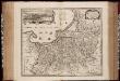
Regni Borussiae Episcopatus Warmiensis Palatinatus Mariaeburgensis et Culmensis cum Territorio Dantiscano et Ichnographia Urbis Regiomontis].
Mollova mapová sbírka

Languages in Prussian Poland
1 : 600000 First World War map of Languages in Prussian Poland. War Office
Die polnische Curve in Westpreußen
Polen Westpreußen Polen Bevölkerung
Provinz Westpreussen
1 : 1250000 Westpreußen
Provinz Westpreussen
1 : 472000 Gdaňsk (Polsko) Handtke, Friedrich Carl Flemming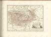

Kolonie założone za panowania Fryderyka Wielkiego w Prusach Królewskich i w obwodzie nadnoteckim
Polen Ostpreußen Netzedistrikt Stadtgründung Friedrich II.
Königsberg, Guttstadt, Biełostok, Suwałki
1 : 750000 Białystok (Polsko : oblast) Konrad, Adalbert K. u. k. Militärgeographisches Institut
Königsberg, Guttstadt, Bielostok, Suwalki
1 : 750000 Białystok (Polsko : oblast) K. k. militär-geographisches Institut
Übersichtskarte von Mittel - Europa

Übersichtskarte von Mittel - Europa

Schema Teatra kampanīi 1806-7 gg.
Polen Napoleonische Kriege

West Preussen.
1 : 940000 Flemming, Carl
Regnum Borussiae gloriosis auspiciis serenissimi et potentissimi princip. Friderici III primi Borussiae regis march. et elect. Brandenburg inauguratum die 18 Jan A 1701
1 : 760000 Prusko Homann, Johann Baptist J.B. Homann
REGNUM BORUSSIAE Gloriosis auspiciis Serenissimi et Potentissimi Pri. FRIDERICI III PRIMI BORUSSIAE REGIS, MARCH. ET ELECT. BRAN. inauguratum die 18. Ian A. 1701 Geographice cum vicinis Regionibus adumbratum
1 : 750000 Prusko Homann, Johann Baptist a Ioh. Baptista Homanno
Regnum Borussiae gloriosis auspiciis serenissimi et potentissimi prin Friderici III primi Borussiae regis, march. et elect. Brandenburg inauguratum die 18. Ian A. 1701
1 : 760000 Prusko Homann, Johann Baptist a Ioh Baptista Homanno
Regnum Borussiae gloriosis auspiciis serenissimi et potentissimi prin Friderici III primi Borussiae regis, march. et elect. Bran inauguratum die 18. Ian. A. 1701
1 : 760000 Prusko Homann, Johann Baptist a Ioh. Baptista Homanno
Regnum Borussiae gloriosis auspiciis serenissimi et potentissimi princ. Friderici III primi Borussiae regis, march. et elect. Brand. inauguratum die 18. Ian. A. 1701
1 : 760000 Prusko Homann, Johann Baptist a Ioh. Baptista Homanno
Regnum Borussiae gloriosis auspiciis serenissimi et potentissimi prin Friderici III primi Borussiae regis, march. et elect. Bran inauguratum die 18. Ian. A. 1701
1 : 760000 Prusko Homann, Johann Baptist a Ioh. Baptista Homanno