Maps of Lenzen-Elbtalaue

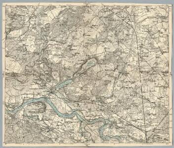
Composite: 212. Lenzen. (Germany)
1 : 100000 Reichsamt fur Landesaufnahme
212. Lenzen. (Germany)
1 : 100000 Reichsamt fur Landesaufnahme
Meßtischblatt 2936 : Schilde, 1934
1 : 250000 Schilde. - Aufn. 1879, einz. Nachtr. 1926. - 1:25000. - [Berlin]: Reichsamt für Landesaufnahme, 1934. - 1 Kt.
Meßtischblatt 2935 : Schnackenburg, 1938
1 : 250000 Schnackenburg. - Hrsg. 1881, redakt. Änd. [19]38. - 1:25000. - [Berlin]: Reichsamt für Landesaufnahme, 1938. - 1 Kt.
Meßtischblatt 2934 : Lenzen, 1924
1 : 250000 Lenzen. - Hrsg. 1881, letzte Nachtr. 1924. - 1:25000. - [Berlin]: Reichsamt für Landesaufnahme, 1924. - 1 Kt.
Meßtischblatt 2836 : Karstädt, 1939
1 : 250000 Karstädt. - Hrsg. 1882. - 1:25000. - [Berlin]: Reichsamt für Landesaufnahme, 1939. - 1 Kt.
Meßtischblatt 1388 : Rambow, 1924
1 : 250000 Rambow. - Aufn. 1879, hrsg. 1881, Nachtr. 1924. - 1:25000. - [Berlin]: Reichsamt für Landesaufnahme, 1924. - 1 Kt.
Meßtischblatt 1387 : Gorlosen, 1936
1 : 250000 Gorlosen. - Hrsg. 1881, Nachtr. 1919. - 1:25000. - [Berlin]: Reichsamt für Landesaufnahme, 1936. - 1 Kt.
Meßtischblatt 2736 : Balow, 1952
1 : 250000 Balow. - Hrsg. 1879, letzte Nachtr. 1924, Ausgabe 1952. - 1:25000. - [S.l.]: Deutsche Wertpapier-Druckerei VEB, 1952. - 1 Kt.
Meßtischblatt 2735 : Grabow a. d. Elde, 1924
1 : 250000 Grabow a. d. Elde. - Hersg. 1881, letzte Nachtr. 1924. - 1:25000. - [Berlin]: Reichsamt für Landesaufnahme, 1924. - 1 Kt.
Meßtischblatt 2734 : Eldena, 1957
1 : 250000 Eldena. - Hrsg. 1881, Ausg. 1919, gedr. [19]37. - 1:25000. - [S.l.]: VD Nord, 1957. - 1 Kt.
Meßtischblatt 2937 : Perleberg, 1941
1 : 250000 Perleberg. - Hrsg. 1881, bericht. 1941. - 1:25000. - [Berlin]: Reichsamt für Landesaufnahme, 1941. - 1 Kt.
Meßtischblatt 2837 : Bäck, 1926
1 : 250000 Bäck. - Hrsg. 1879. - 1:25000. - [Berlin]: Reichsamt für Landesaufnahme, 1926. - 1 Kt.
Meßtischblatt 2737 : Hülsebeck, 1936
1 : 250000 Hülsebeck. - Hrsg. 1881, kl. Nachtr. 1924, gedr. [19]36. - 1:25000. - [Berlin]: Reichsamt für Landesaufnahme, 1936. - 1 Kt.
59. Ludwigslust, uit: Topographische Uebersichtskarte des Deutschen Reiches / herausgegeben v. d. Kartogr. Abt. d. Königl. Preuß. Landesaufnahme
1 : 200000 titelvariant: Topogr. Übersichtskarte des Deutschen Reiches; Annotatie: Titel boven bladen ook: Topogr. Übersichtskarte des Deutschen Reiches; Annotatie geografische gegevens: Op elk blad twee maatstokken: 10 Kilometer = 5,5 cm; 1 geogr. Meile = 3,6 cm; Legenda onder op elk blad Königlich Preußische Landesaufnahme. Kartographische Abtheilung [S.l : Königlich Preußische Landesaufnahme, Kartographische Abtheilung]
181. Ludwigslust. (Germany)
1 : 100000 Reichsamt fur Landesaufnahme
213. Perleberg. (Germany)
1 : 100000 Reichsamt fur Landesaufnahme
Composite: 213. Perleberg. (Germany)
1 : 100000 Reichsamt fur Landesaufnahme
Meßtischblatt 2933 : Gr. Gusborn, 1940
1 : 250000 Gr. Gusborn. - Hrsg. 1881. - 1:25000. - [Berlin]: Reichsamt für Landesaufnahme, 1940. - 1 Kt.
Meßtischblatt 2833 : Dömitz, 1953
1 : 250000 Dömitz. - Hrsg. 1881, letzte Nachtr. 1939. - 1:25000. - [S.l.]: MdI, 1953. - 1 Kt.
Meßtischblatt 2733 : Leussow, 1939
1 : 250000 Leussow. - Hrsg. 1881, ber. 1906, einz. Nachtr. 1939. - 1:25000. - [Berlin]: Reichsamt für Landesaufnahme, 1939. - 1 Kt.
Wittenberge 46, uit: Special-Karte von Mittel-Europa / nach amtlichen Quellen bearbeitet von W. Liebenow
1 : 300000 titelvariant: W. Liebenow's Mittel-Europa; Annotatie: Titel boven de bladen: W. Liebenow's Mittel-Europa Johannes Wilhelm Liebenow 1822-1897 Frankfurt a. M. : Ludwig Ravenstein
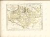
Mappa Ducatus Megalopolitani Nova :
1 : 190000 Mollova mapová sbírka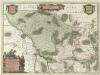
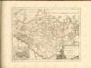
Marchionatvs Brandenburgici
1 : 330000 Mollova mapová sbírka Örnehufvud, Olof Hansson Covens, Johannes I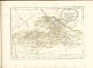

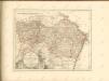
MARCHIONATUS | BRANDENBURGICI | PARTES DUÆ, | RUPPIN | Comitatus | & | PRIGNITS | Regiuncula
Auct. Olao Iohannis Gotho, Gustavo Magno Cosm. [Amsterdam : Joan Blaeu]