Maps of gmina Jastrowie

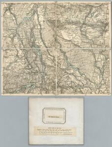
191. Deutsch-Krone. (Germany)
1 : 100000 Reichsamt fur Landesaufnahme
Composite: 191. Deutsch-Krone. (Germany)
1 : 100000 Reichsamt fur Landesaufnahme
Meßtischblatt 2665 : Freudenfier, 1940
1 : 250000 Freudenfier. - Aufn. 1933/34. - 1:25000. - [Berlin]: Reichsamt für Landesaufnahme, 1940. - 1 Kt.
Meßtischblatt 2666 : Betkenhammer, 1944
1 : 250000 Betkenhammer. - Aufn. 1935. - 1:25000. - [Berlin]: Reichsamt für Landesaufnahme, 1944. - 1 Kt.
Meßtischblatt 2565 : Zippnow, 1935
1 : 250000 Zippnow. - Aufgen. 1935. - 1:25000. - [Berlin]: Reichsamt für Landesaufnahme, 1935. - 1 Kt.
Meßtischblatt 2566 : Jastrow, 1935
1 : 250000 Jastrow. - Aufgen. 1935. - 1:25000. - [Berlin]: Reichsamt für Landesaufnahme, 1935. - 1 Kt.
Meßtischblatt 2664 : Neugolz. 1940
1 : 250000 Neugolz. - Aufn. 1934. - 1:25000. - [Berlin]: Reichsamt für Landesaufnahme, 1940. - 1 Kt.
Meßtischblatt 2564 : Rederitz, 1934
1 : 250000 Rederitz. - Aufgen. 1933/34. - 1:25000. - [Berlin]: Reichsamt für Landesaufnahme, 1934. - 1 Kt.
Meßtischblatt 2766 : Lebehnke, 1938
1 : 250000 Lebehnke. - Aufn. 1935. - 1:25000. - [Berlin]: Reichsamt für Landesaufnahme, 1938. - 1 Kt.
Meßtischblatt 2765 : Breitenstein, 1878
1 : 250000 Breitenstein. - Aufn. 1876. - 1:25000. - [Berlin]: Reichsamt für Landesaufnahme, 1878. - 1 Kt.
Meßtischblatt 2764 : Deutsch Krone, 1937
1 : 250000 Deutsch Krone. - Aufn. 1928/34. - 1:25000. - [Berlin]: Reichsamt für Landesaufnahme, 1937. - 1 Kt.
Tempelburg 37, uit: Special-Karte von Mittel-Europa / nach amtlichen Quellen bearbeitet von W. Liebenow
1 : 300000 titelvariant: W. Liebenow's Mittel-Europa; Annotatie: Titel boven de bladen: W. Liebenow's Mittel-Europa Johannes Wilhelm Liebenow 1822-1897 Frankfurt a. M. : Ludwig Ravenstein
Der Arenswaldische Creis
1 : 290000 Sotzmann, Daniel Friedrich
Der Dramburgsche Creis
1 : 296000 Drawsko Pomorskie (Polsko) Sotzmann, Daniel Friedrich
Composite: 222. Schneidermuhl.
1 : 100000 Reichsamt fur Landesaufnahme
222. Schneidermuhl.
1 : 100000 Reichsamt fur Landesaufnahme
Composite: 192. Flatow. (Germany)
1 : 100000 Reichsamt fur Landesaufnahme
Meßtischblatt 2667 : Tarnowke, 1933
1 : 250000 Tarnowke. - Aufgen. 1928. - 1:25000. - [Berlin]: Reichsamt für Landesaufnahme, 1933. - 1 Kt.
Meßtischblatt 2567 : Flederborn, 1934
1 : 250000 Flederborn. - Aufgen. 1928, hrsg. 1933, einz. Nachtr. 1934. - 1:25000. - [Berlin]: Reichsamt für Landesaufnahme, 1934. - 1 Kt.

Bromberg
1 : 600000 Opitz, Carl Solbrig
Provinz Posen
1 : 1200000 Provinz Posen
Posen.
1 : 810000 Radefeld, Carl Christian Franz, 1788-1874
Palatinatus Posnaniensis. In Majori Polonia Primarii Nova Delinatio [Karte], in: Novus atlas absolutissimus, Bd. 1, S. 96.
1 Karte aus Atlas Janssonius Offizin
Languages in Prussian Poland
1 : 600000 First World War map of Languages in Prussian Poland. War Office
Die polnische Curve in Westpreußen
Polen Westpreußen Polen Bevölkerung
Provinz Westpreussen
1 : 1250000 Westpreußen
Kreise der Provinz Posen 1864
Preußen, Provinz Posen, Verwaltungsgliederung Kunz, Andreas ; Moeschl, Joachim Robert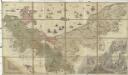
Ducatus Pomeraniae citerioris et ulterioris principatibus, comitatibus urbibus suis definitae nova et ampla descriptio
1 : 257000 Pomořansko (Německo a Polsko) Lotter, Tobias Conrad T. C. Lotter