Maps of Samtgemeinde Selsingen

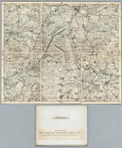
176. Bremervorde. (Germany)
1 : 100000 Reichsamt fur Landesaufnahme
Composite: 176. Bremervorde. (Germany)
1 : 100000 Reichsamt fur Landesaufnahme
Meßtischblatt 1208 : Selsingen, 1918
1 : 250000 Selsingen. - Aufn. 1897, hrsg. 1899, Auflagedr. 1918. - 1:25000. - [Berlin]: Reichsamt für Landesaufnahme, 1918. - 1 Kt.
Meßtischblatt 1207 : Rhade, 1899
1 : 250000 Rhade. - Aufn. 1897, hrsg. 1899. - 1:25000. - [Berlin]: Reichsamt für Landesaufnahme, 1899. - 1 Kt.
Meßtischblatt 1206 : Kuhstedt, 1899
1 : 250000 Kuhstedt. - Aufn. 1897. - 1:25000. - [Berlin]: Reichsamt für Landesaufnahme, 1899. - 1 Kt.
Meßtischblatt 1116 : Bremervörde, 1899
1 : 250000 Bremervörde. - Aufn. 1897, hrsg. 1899. - 1:25000. - [Berlin]: Reichsamt für Landesaufnahme, 1899. - 1 Kt.
Meßtischblatt 1293 : Zeven, 1925
1 : 250000 Zeven. - Aufn. 1897, einz. Nachtr. 1925. - 1:25000. - [Berlin]: Reichsamt für Landesaufnahme, 1925. - 1 Kt.
Meßtischblatt 1292 : Kirchtimke, 1936
1 : 250000 Kirchtimke. - Hrsg. 1899, bericht. 1913, Nachtr. 1925, gedr. [19]36. - 1:25000. - [Berlin]: Reichsamt für Landesaufnahme, 1936. - 1 Kt.
Meßtischblatt 1291 : Worpswede, 1935
1 : 250000 Worpswede. - Hrsg. 1899, bericht. 1913. - 1:25000. - [Berlin]: Reichsamt für Landesaufnahme, 1935. - 1 Kt.
Meßtischblatt 1291 : Worpswede, 1899
1 : 250000 Worpswede. - Aufn. 1897. - 1:25000. - [Berlin]: Reichsamt für Landesaufnahme, 1899. - 1 Kt.
56. Bremen, uit: Topographische Uebersichtskarte des Deutschen Reiches / herausgegeben v. d. Kartogr. Abt. d. Königl. Preuß. Landesaufnahme
1 : 200000 titelvariant: Topogr. Übersichtskarte des Deutschen Reiches; Annotatie: Titel boven bladen ook: Topogr. Übersichtskarte des Deutschen Reiches; Annotatie geografische gegevens: Op elk blad twee maatstokken: 10 Kilometer = 5,5 cm; 1 geogr. Meile = 3,6 cm; Legenda onder op elk blad Königlich Preußische Landesaufnahme. Kartographische Abtheilung [S.l : Königlich Preußische Landesaufnahme, Kartographische Abtheilung]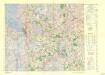
Central Europe 1:1,000,000, Bremerhaven
Sheet L3 of the 287 sheet series: Central Europe. 1 : 100,000. G.S.G.S. No. 4416. AMS. M641, M651, M671. [London?] ; Washington, D.C. : War Office : Army Map Service, U.S. Army.
A General Prospect of the Royall House and Garding at Hernhausen
Mollova mapová sbírka Müller, Johann Jacob Sassen, Joost van Schenk, Peter I
177. Buxtehude. (Germany)
1 : 100000 Reichsamt fur Landesaufnahme
Composite: 207. Ottersberg. (Germany)
1 : 100000 Reichsamt fur Landesaufnahme
Meßtischblatt 1208 : Heeslingen, 1918
1 : 250000 Heeslingen. - Aufn. 1897, hrsg. 1899, Auflagedr. 1918. - 1:25000. - [Berlin]: Reichsamt für Landesaufnahme, 1918. - 1 Kt.
Meßtischblatt 1118 : Bargstedt, 1899
1 : 250000 Bargstedt. - Aufn. 1897, hrsg. 1899. - 1:25000. - [Berlin]: Reichsamt für Landesaufnahme, 1899. - 1 Kt.
Meßtischblatt 1205, neue Nr. 2618 : Hambergen, 1937
1 : 250000 Hambergen. - Hrsg. 1900, bericht. 1913, einz. Nachtr. 1937. - 1:25000. - [Berlin]: Reichsamt für Landesaufnahme, 1937. - 1 Kt.
Meßtischblatt 1114 : Beverstedt, 1900
1 : 250000 Beverstedt. - Aufn. 1898. - 1:25000. - [Berlin]: Reichsamt für Landesaufnahme, 1900. - 1 Kt.
Meßtischblatt 2722 : Elsdorf, 1938
1 : 250000 Elsdorf. - Hrsg. 1899, bericht. 1913, einz. Nachtr. 1938. - 1:25000. - [Berlin]: Reichsamt für Landesaufnahme, 1938. - 1 Kt.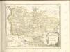

Dvcatvs Bremae et Princ. Verdae
1 : 200000 Mollova mapová sbírka
Paskaart vande Iade, Weser en Elve :
1 : 250000 Mollova mapová sbírka Keulen, Johannes van Keulen, Johannes van

Das Hertzogthum Bremen nebst dem Stifft oder Fürstenthum Verden im Nieder Sächsischen Creiss
1 : 750000 Mollova mapová sbírka Weigel, Johann Christoph Weigel, Johann Christoph
Le Duché de Bremen et Ferden
1 : 370000 Mollova mapová sbírka Le Rouge, Georges-Louis Le Rouge, Georges-Louis
Ducatus Bremae & Ferdae maximaeque partis fluminis Visurgis descriptio
1 : 320000 per Fredericum de Witt Amstelodami uytgegeven door Reinier & Josua Ottens, voor aen op den Nieuwendyck in de Warelt [Amsterdam] : ex officina R. & J. Ottens

Ducatus olim episcopatus Bremensis et ostiorum Albis et Visurgis fluviorum, novissima descriptio
1 : 308000 Brémy (Německo : spolková země) Graaf, Cornelius de Ioannes Ianßonius