Maps of gmina Pisz

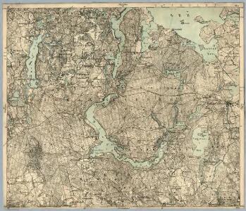
Composite: 169. Johannisburg. (Germany)
1 : 100000 Reichsamt fur Landesaufnahme
169. Johannisburg. (Germany)
1 : 100000 Reichsamt fur Landesaufnahme
Meßtischblatt 2495 : Mittenheide, 1938
1 : 250000 Mittenheide. - Hrsg. 1921, einz. Nachtr. 1927, redakt. Änd. 193. - 1:25000. - [Berlin]: Reichsamt für Landesaufnahme, 1938. - 1 Kt.
Meßtischblatt 2494 : Farienen, 1938
1 : 250000 Farienen. - Hrsg. 1921, einz. Nachtr. 1929, redakt. Änd. 193. - 1:25000. - [Berlin]: Reichsamt für Landesaufnahme, 1938. - 1 Kt.
Meßtischblatt 2496 : Mittel- Pogauen, 1929
1 : 250000 Mittel- Pogauen. - Hrsg. 1921, einz. Nachtr. 1929. - 1:25000. - [Berlin]: Reichsamt für Landesaufnahme, 1929. - 1 Kt.
Meßtischblatt 2395 : Niedersee, 1938
1 : 250000 Niedersee. - Aufn. 1921, bericht. 1929, redakt. Änd. 1938. - 1:25000. - [Berlin]: Reichsamt für Landesaufnahme, 1938. - 1 Kt.
Meßtischblatt 2394 : Eckertsdorf, 1938
1 : 250000 Eckertsdorf. - Aufn. 1922, bericht. 1929, redakt. Änd. 1938. - 1:25000. - [Berlin]: Reichsamt für Landesaufnahme, 1938. - 1 Kt.
Meßtischblatt 2396 : Johannisburg, 1938
1 : 250000 Johannisburg. - Aufn. 1921, einz. Nachtr. 1929, redakt. Änd. 193. - 1:25000. - [Berlin]: Reichsamt für Landesaufnahme, 1938. - 1 Kt.
Meßtischblatt 2294 : Peitschendorf, 1938
1 : 250000 Peitschendorf. - Hrsg. 1927, einz. Nachtr. 1928, redakt. Änd. 1938. - 1:25000. - [Berlin]: Reichsamt für Landesaufnahme, 1938. - 1 Kt.
Meßtischblatt 2295 : Biebern, 1938
1 : 250000 Biebern. - Hrsg. 1921, einz. Nachtr. 1928, redakt. Änd. 1938. - 1:25000. - [Berlin]: Reichsamt für Landesaufnahme, 1938. - 1 Kt.
Meßtischblatt 2296 : Dorren, 1938
1 : 250000 Dorren. - Hrsg. 1926, redakt. Änd. 1938. - 1:25000. - [Berlin]: Reichsamt für Landesaufnahme, 1938. - 1 Kt.
28 Lötzen, uit: Special-Karte von Mittel-Europa / nach amtlichen Quellen bearbeitet von W. Liebenow
1 : 300000 titelvariant: W. Liebenow's Mittel-Europa; Annotatie: Titel boven de bladen: W. Liebenow's Mittel-Europa Johannes Wilhelm Liebenow 1822-1897 Frankfurt a. M. : Ludwig Ravenstein
Regni Borussiae Episcopatus Warmiensis Palatinatus Mariaeburgensis et Culmensis cum Territorio Dantiscano et Ichnographia Urbis Regiomontis].
Mollova mapová sbírka

Composite: 136. Nikolaiken. (Germany)
1 : 100000 Reichsamt fur Landesaufnahme
136. Nikolaiken. (Germany)
1 : 100000 Reichsamt fur Landesaufnahme
Meßtischblatt 2596 : Wondollek, 1938
1 : 250000 Wondollek. - Aufn. 1910, bericht. 1927. - 1:25000. - [Berlin]: Reichsamt für Landesaufnahme, 1938. - 1 Kt.
Meßtischblatt 2595 : Karpa, 1938
1 : 250000 Karpa. - Hrsg. 1910, bericht. 1927. - 1:25000. - [Berlin]: Reichsamt für Landesaufnahme, 1938. - 1 Kt.
Meßtischblatt 2594 : Friedrichshof, 1938
1 : 250000 Friedrichshof. - Hrsg. 1910, bericht. 1927. - 1:25000. - [Berlin]: Reichsamt für Landesaufnahme, 1938. - 1 Kt.
Sect. 11: Allenstein, uit: Geologische Karte des Deutschen Reichs in 27 Blaettern / [von] Richard Lepsius ; Red. von C. Vogel
1 : 500000 Annotatie: Blad 18 ontbreekt; Een aantal bladen op linnen; Een aantal bladen gereviseerd 1913-1914; Annotatie geografische gegevens: Met schaalstokken o.a. in kilometers; Legenda Carl Vogel 1828-1897 Gotha : Justus Perthes
Nr. 21a. Weitere Ergebnisse der Winterschlacht in Masuren
Masuren Weltkrieg <1914-1918>, Ostfront
Provinz Ostpreussen
1 : 1250000 Ostpreußen
Litauisch und Masurisch
Ostpreußen Litauisch, Masurisch
Königsberg, Guttstadt, Biełostok, Suwałki
1 : 750000 Białystok (Polsko : oblast) Konrad, Adalbert K. u. k. Militärgeographisches Institut
Königsberg, Guttstadt, Bielostok, Suwalki
1 : 750000 Białystok (Polsko : oblast) K. k. militär-geographisches Institut
Ost-Preussen.
1 : 935000 Flemming, Carl
Übersichtskarte von Mittel - Europa

Übersichtskarte von Mittel - Europa