Maps of gmina Szczytno

Composite: 168. Ortelsburg. (Germany)
1 : 100000 Reichsamt fur Landesaufnahme
168. Ortelsburg. (Germany)
1 : 100000 Reichsamt fur Landesaufnahme
Meßtischblatt 1096 : Ortelsburg, 1915
1 : 250000 Ortelsburg. - Aufn. 1912, hrsg. 1914, Auflagedr. 1915. - 1:25000. - [Berlin]: Reichsamt für Landesaufnahme, 1915. - 1 Kt.
Meßtischblatt 2491 : Ortelsburg (West), 1938
1 : 250000 Ortelsburg (West). - Hrsg. 1915, bericht. 1929, redakt. Änd. 1938. - 1:25000. - [Berlin]: Reichsamt für Landesaufnahme, 1938. - 1 Kt.
Meßtischblatt 1097 : Schwentainen, 1915
1 : 250000 Schwentainen. - Aufn. 1912, hrsg. 1914, Auflagedr. 1915. - 1:25000. - [Berlin]: Reichsamt für Landesaufnahme, 1915. - 1 Kt.
Meßtischblatt 2392 : Mingfen, 1938
1 : 250000 Mingfen. - Aufn. 1914, bericht. 1929, redakt. Änd. 1938. - 1:25000. - [Berlin]: Reichsamt für Landesaufnahme, 1938. - 1 Kt.
Meßtischblatt 2391 : Grammen, 1938
1 : 250000 Grammen. - Aufn. 1915, bericht. 1929, redakt. Änd. 1938. - 1:25000. - [Berlin]: Reichsamt für Landesaufnahme, 1938. - 1 Kt.
Meßtischblatt 2393 : Babienten, 1929
1 : 250000 Babienten. - Aufn. 1915, bericht. 1929. - 1:25000. - [Berlin]: Reichsamt für Landesaufnahme, 1929. - 1 Kt.
Meßtischblatt 2291 : Mensguth, 1938
1 : 250000 Mensguth. - Hrsg. 1915, bericht. 1929, redakt. Änd. 1938. - 1:25000. - [Berlin]: Reichsamt für Landesaufnahme, 1938. - 1 Kt.
Meßtischblatt 2292 : Ribben, 1938
1 : 250000 Ribben. - Hrsg. 1914, einz. Nachtr. 1929, redakt. Änd. 193. - 1:25000. - [Berlin]: Reichsamt für Landesaufnahme, 1938. - 1 Kt.
Meßtischblatt 2293 : Aweyden, 1938
1 : 250000 Aweyden. - Hrsg. 1915, einz. Nachtr. 1929, redakt. Änd. 193. - 1:25000. - [Berlin]: Reichsamt für Landesaufnahme, 1938. - 1 Kt.
28 Lötzen, uit: Special-Karte von Mittel-Europa / nach amtlichen Quellen bearbeitet von W. Liebenow
1 : 300000 titelvariant: W. Liebenow's Mittel-Europa; Annotatie: Titel boven de bladen: W. Liebenow's Mittel-Europa Johannes Wilhelm Liebenow 1822-1897 Frankfurt a. M. : Ludwig Ravenstein
Regni Borussiae Episcopatus Warmiensis Palatinatus Mariaeburgensis et Culmensis cum Territorio Dantiscano et Ichnographia Urbis Regiomontis].
Mollova mapová sbírka

Östlicher Kriegsschauplatz II: Schlacht bei Tannenberg
1 : 750000 Tannenberg Schlacht bei Tannenberg <1914>
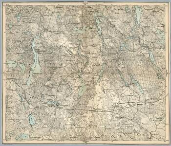
Composite: 135. Sensburg. (Germany)
1 : 100000 Reichsamt fur Landesaufnahme
Meßtischblatt 2394 : Eckertsdorf, 1938
1 : 250000 Eckertsdorf. - Aufn. 1922, bericht. 1929, redakt. Änd. 1938. - 1:25000. - [Berlin]: Reichsamt für Landesaufnahme, 1938. - 1 Kt.
Meßtischblatt 2494 : Farienen, 1938
1 : 250000 Farienen. - Hrsg. 1921, einz. Nachtr. 1929, redakt. Änd. 193. - 1:25000. - [Berlin]: Reichsamt für Landesaufnahme, 1938. - 1 Kt.
Meßtischblatt 2294 : Peitschendorf, 1938
1 : 250000 Peitschendorf. - Hrsg. 1927, einz. Nachtr. 1928, redakt. Änd. 1938. - 1:25000. - [Berlin]: Reichsamt für Landesaufnahme, 1938. - 1 Kt.
Meßtischblatt 2593/2693 : Liebenberg, 1938
1 : 250000 Liebenberg. - Hrsg. 1911, bericht. 1927. - 1:25000. - [Berlin]: Reichsamt für Landesaufnahme, 1938. - 1 Kt.
Meßtischblatt 2592 : Lindenort, 1938
1 : 250000 Lindenort. - Hrsg. 1911, bericht. 1927, redakt. Änd. 1938. - 1:25000. - [Berlin]: Reichsamt für Landesaufnahme, 1938. - 1 Kt.
Meßtischblatt 2591 : Willenberg (Nord), 1938
1 : 250000 Willenberg (Nord). - Hrsg. 1911, bericht. 1927, einz. Nachtr. 1929, redakt. Änd. 1938. - 1:25000. - [Berlin]: Reichsamt für Landesaufnahme, 1938. - 1 Kt.
Sect. 11: Allenstein, uit: Geologische Karte des Deutschen Reichs in 27 Blaettern / [von] Richard Lepsius ; Red. von C. Vogel
1 : 500000 Annotatie: Blad 18 ontbreekt; Een aantal bladen op linnen; Een aantal bladen gereviseerd 1913-1914; Annotatie geografische gegevens: Met schaalstokken o.a. in kilometers; Legenda Carl Vogel 1828-1897 Gotha : Justus Perthes
Provinz Ostpreussen
1 : 1250000 Ostpreußen
Litauisch und Masurisch
Ostpreußen Litauisch, Masurisch
Prvssia
1 Karte : Kupferdruck ; 35 x 47 cm Mercator; Hondius Henricus Hondius
Königsberg, Guttstadt, Biełostok, Suwałki
1 : 750000 Białystok (Polsko : oblast) Konrad, Adalbert K. u. k. Militärgeographisches Institut
Königsberg, Guttstadt, Bielostok, Suwalki
1 : 750000 Białystok (Polsko : oblast) K. k. militär-geographisches Institut
Ost-Preussen.
1 : 935000 Flemming, Carl