Maps of gmina Purda

Composite: 167. Passenheim. (Germany)
1 : 100000 Reichsamt fur Landesaufnahme
167. Passenheim. (Germany)
1 : 100000 Reichsamt fur Landesaufnahme
Meßtischblatt 2389 : Wuttrienen, 1934
1 : 250000 Wuttrienen. - Aufn. 1914, bericht. 1929. - 1:25000. - [Berlin]: Reichsamt für Landesaufnahme, 1934. - 1 Kt.
Meßtischblatt 2390 : Passenheim, 1938
1 : 250000 Passenheim. - Aufn. 1914, bericht. 1929, redakt. Änd. 1938. - 1:25000. - [Berlin]: Reichsamt für Landesaufnahme, 1938. - 1 Kt.
Meßtischblatt 1093 : Gimmendorf, 1914
1 : 250000 Gimmendorf. - Aufn. 1912, hrsg. 1914, Auflagedr. 1914. - 1:25000. - [Berlin]: Reichsamt für Landesaufnahme, 1914. - 1 Kt.
Meßtischblatt 2490 : Gedwangen, 1938
1 : 250000 Gedwangen. - Hrsg. 1915, bericht. 1929, redakt. Änd. 1938. - 1:25000. - [Berlin]: Reichsamt für Landesaufnahme, 1938. - 1 Kt.
Meßtischblatt 2388 : Grieslienen, 1938
1 : 250000 Grieslienen. - Aufn. 1914, bericht. 1929, redakt. Änd. 1938. - 1:25000. - [Berlin]: Reichsamt für Landesaufnahme, 1938. - 1 Kt.
Meßtischblatt 2488 : Kurken, 1938
1 : 250000 Kurken. - Hrsg. 1914, bericht. 1929, redakt. Änd. 1938. - 1:25000. - [Berlin]: Reichsamt für Landesaufnahme, 1938. - 1 Kt.
Meßtischblatt 2289 : Gr. Kleeberg, 1929
1 : 250000 Gr. Kleeberg. - Hrsg. 1914, bericht. 1929. - 1:25000. - [Berlin]: Reichsamt für Landesaufnahme, 1929. - 1 Kt.
Meßtischblatt 2290 : Gr. Purden, 1938
1 : 250000 Gr. Purden. - Hrsg. 1914, bericht. 1929, redakt. Änd. 1938. - 1:25000. - [Berlin]: Reichsamt für Landesaufnahme, 1938. - 1 Kt.
Meßtischblatt Allenstein
1 : 250000 Allenstein. - Hrsg. 1914, bericht. 1929, redakt. Änd. 1938. - 1:25000. - [Berlin]: Reichsamt für Landesaufnahme, 1938. - 1 Kt.
Östlicher Kriegsschauplatz II: Schlacht bei Tannenberg
1 : 750000 Tannenberg Schlacht bei Tannenberg <1914>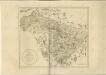

28 Lötzen, uit: Special-Karte von Mittel-Europa / nach amtlichen Quellen bearbeitet von W. Liebenow
1 : 300000 titelvariant: W. Liebenow's Mittel-Europa; Annotatie: Titel boven de bladen: W. Liebenow's Mittel-Europa Johannes Wilhelm Liebenow 1822-1897 Frankfurt a. M. : Ludwig Ravenstein
199.1. Neidenburg. 230.1 Bialutten. (Germany)
1 : 100000 Reichsamt fur Landesaufnahme
Composite: 199.1. Neidenburg. 230.1. Bialutten. (Germany)
1 : 100000 Reichsamt fur Landesaufnahme

Operationskarte
1 : 300000 Annotatie: Uit Bd. 4 van: Der Krieg von 1806 und 1807 / O. von Lettow-Vorbeck. - Berlin : Mittler, 1896; Fotogr. reprod. van origineel uit: Der Krieg von 1806 und 1807 ... / E. von Höpfner. - Berlin : Schropp, 1850 Berlin : Mittler
Regni Borussiae Episcopatus Warmiensis Palatinatus Mariaeburgensis et Culmensis cum Territorio Dantiscano et Ichnographia Urbis Regiomontis].
Mollova mapová sbírka

Sect. 11: Allenstein, uit: Geologische Karte des Deutschen Reichs in 27 Blaettern / [von] Richard Lepsius ; Red. von C. Vogel
1 : 500000 Annotatie: Blad 18 ontbreekt; Een aantal bladen op linnen; Een aantal bladen gereviseerd 1913-1914; Annotatie geografische gegevens: Met schaalstokken o.a. in kilometers; Legenda Carl Vogel 1828-1897 Gotha : Justus Perthes
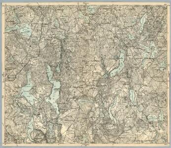
Provinz Ostpreussen
1 : 1250000 Ostpreußen
Litauisch und Masurisch
Ostpreußen Litauisch, Masurisch
Prvssia
1 Karte : Kupferdruck ; 35 x 47 cm Mercator; Hondius Henricus Hondius
Königsberg, Guttstadt, Biełostok, Suwałki
1 : 750000 Białystok (Polsko : oblast) Konrad, Adalbert K. u. k. Militärgeographisches Institut
Königsberg, Guttstadt, Bielostok, Suwalki
1 : 750000 Białystok (Polsko : oblast) K. k. militär-geographisches Institut
Ost-Preussen.
1 : 935000 Flemming, Carl
Übersichtskarte von Mittel - Europa

Übersichtskarte von Mittel - Europa