Maps of gmina Borne Sulinowo

159. Neustettin. (Germany)
1 : 100000 Reichsamt fur Landesaufnahme
Meßtischblatt 2465 : Gr. Born, 1940
1 : 250000 Gr. Born. - Aufn. 1934, letzte Nachtr. 1936 - 39. - 1:25000. - [Berlin]: Reichsamt für Landesaufnahme, 1940. - 1 Kt.
Meßtischblatt 2464 : Neblin, 1877
1 : 250000 Neblin. - Aufn. 1875. - 1:25000. - [Berlin]: Reichsamt für Landesaufnahme, 1877. - 1 Kt.
Meßtischblatt 2365 : Gellen, 1940
1 : 250000 Gellen. - Hrsg. 1935, Ausg. 1940. - 1:25000. - [Berlin]: Reichsamt für Landesaufnahme, 1940. - 1 Kt.
Meßtischblatt 2364 : Pielburg, 1936
1 : 250000 Pielburg. - Hrsg. 1935, mehrfarb. hrsg. 1935, Ausg. 1936. - 1:25000. - [Berlin]: Reichsamt für Landesaufnahme, 1936. - 1 Kt.
Meßtischblatt 2466 : Barkenbrügge, 1940
1 : 250000 Barkenbrügge. - Aufn. 1935, letzte Nachtr. 1936/39. - 1:25000. - [Berlin]: Reichsamt für Landesaufnahme, 1940. - 1 Kt.
Meßtischblatt 974, neue Nr. 2366 : Thurow, 1937
1 : 250000 Thurow. - Aufgen. 1933/34, hrsg. 1937. - 1:25000. - [Berlin]: Reichsamt für Landesaufnahme, 1937. - 1 Kt.
Meßtischblatt 2264 : Bärwalde, 1940
1 : 250000 Bärwalde. - Aufn. 1934, redakt. Änd. 1938. - 1:25000. - [Berlin]: Reichsamt für Landesaufnahme, 1940. - 1 Kt.
Meßtischblatt 876, neue Nr. 2265 : Persanzig, 1937
1 : 250000 Persanzig. - Aufn. 1933/34. - 1:25000. - [Berlin]: Reichsamt für Landesaufnahme, 1937. - 1 Kt.
Meßtischblatt 877, neue Nr. 2266 : Neustettin, 1936
1 : 250000 Neustettin. - Neuaufn. 1935, mehrfarb. Ausg. 1936. - 1:25000. - [Berlin]: Reichsamt für Landesaufnahme, 1936. - 1 Kt.
Meßtischblatt 2463 : Tempelburg, 1937
1 : 250000 Tempelburg. - Aufgen. 1937. - 1:25000. - [Berlin]: Reichsamt für Landesaufnahme, 1937. - 1 Kt.
Meßtischblatt 2363 : Pöhlen, 1937
1 : 250000 Pöhlen. - Aufgen. 1937. - 1:25000. - [Berlin]: Reichsamt für Landesaufnahme, 1937. - 1 Kt
Tempelburg 37, uit: Special-Karte von Mittel-Europa / nach amtlichen Quellen bearbeitet von W. Liebenow
1 : 300000 titelvariant: W. Liebenow's Mittel-Europa; Annotatie: Titel boven de bladen: W. Liebenow's Mittel-Europa Johannes Wilhelm Liebenow 1822-1897 Frankfurt a. M. : Ludwig Ravenstein
Der Dramburgsche Creis
1 : 296000 Drawsko Pomorskie (Polsko) Sotzmann, Daniel Friedrich
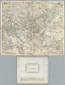
158. Tempelburg. (Germany)
1 : 100000 Reichsamt fur Landesaufnahme
Composite: 158. Tempelburg. (Germany)
1 : 100000 Reichsamt fur Landesaufnahme
Composite: 126. Bublitz. (Germany)
1 : 100000 Reichsamt fur Landesaufnahme
126. Bublitz. (Germany)
1 : 100000 Reichsamt fur Landesaufnahme
Composite: 191. Deutsch-Krone. (Germany)
1 : 100000 Reichsamt fur Landesaufnahme
Meßtischblatt 2565 : Zippnow, 1935
1 : 250000 Zippnow. - Aufgen. 1935. - 1:25000. - [Berlin]: Reichsamt für Landesaufnahme, 1935. - 1 Kt.
Meßtischblatt 2564 : Rederitz, 1934
1 : 250000 Rederitz. - Aufgen. 1933/34. - 1:25000. - [Berlin]: Reichsamt für Landesaufnahme, 1934. - 1 Kt.
Meßtischblatt 2566 : Jastrow, 1935
1 : 250000 Jastrow. - Aufgen. 1935. - 1:25000. - [Berlin]: Reichsamt für Landesaufnahme, 1935. - 1 Kt.
Meßtischblatt 2263 : Kollatz, 1891
1 : 250000 Kollatz. - [Aufn. 1889]. - 1:25000. - [Berlin]: Reichsamt für Landesaufnahme, 1891. - 1 Kt.
191. Deutsch-Krone. (Germany)
1 : 100000 Reichsamt fur Landesaufnahme
Meßtischblatt 2563 : Gr. Linichen, 1937
1 : 250000 Gr. Linichen. - Aufgen. 1937. - 1:25000. - [Berlin]: Reichsamt für Landesaufnahme, 1937. - 1 Kt.

Bromberg
1 : 600000 Opitz, Carl Solbrig
Languages in Prussian Poland
1 : 600000 First World War map of Languages in Prussian Poland. War Office
Die polnische Curve in Westpreußen
Polen Westpreußen Polen Bevölkerung