Maps of gmina Łobez

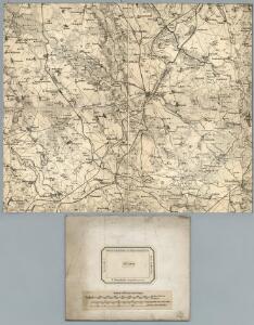
157. Labes. (Germany)
1 : 100000 Reichsamt fur Landesaufnahme
Composite: 157. Labes. (Germany)
1 : 100000 Reichsamt fur Landesaufnahme
Meßtischblatt 2460 : Dramburg, 1943
1 : 250000 Dramburg. - Aufn. 1890, hrsg. 1892, bericht. 1936. - 1:25000. - [Berlin]: Reichsamt für Landesaufnahme, 1943. - 1 Kt.
Meßtischblatt 1063 : Wangerin, 1938
1 : 250000 Wangerin. - Aufn. 1890, hrsg. 1892, bericht. 1936. - 1:25000. - [Berlin]: Reichsamt für Landesaufnahme, 1938. - 1 Kt.
Meßtischblatt 1062 : Silligsdorf, 1936
1 : 250000 Silligsdorf. - Hrsg. 1892, bericht. 1936. - 1:25000. - [Berlin]: Reichsamt für Landesaufnahme, 1936. - 1 Kt.
Meßtischblatt 2360 : Labenz, 1936
1 : 250000 Labenz. - Hrsg. 1892, bericht. 1936. - 1:25000. - [Berlin]: Reichsamt für Landesaufnahme, 1936. - 1 Kt.
Meßtischblatt 967 : Labes, 1892
1 : 250000 Labes. - Aufn. 1890. - 1:25000. - [Berlin]: Reichsamt für Landesaufnahme, 1892. - 1 Kt.
Meßtischblatt 966 : Gr. Borckenhagen, 1892
1 : 250000 Gr. Borckenhagen. - Aufn. 1890. - 1:25000. - [Berlin]: Reichsamt für Landesaufnahme, 1892. - 1 Kt.
Meßtischblatt 869 : Regenwalde, 1890
1 : 250000 Regenwalde. - Aufn. 1889. - 1:25000. - [Berlin]: Reichsamt für Landesaufnahme, 1890. - 1 Kt.
Meßtischblatt 870 : Rützenhagen, 1891
1 : 250000 Rützenhagen. - Aufn. 1889. - 1:25000. - [Berlin]: Reichsamt für Landesaufnahme, 1891. - 1 Kt.
Meßtischblatt 871 : Schivelbein, 1890
1 : 250000 Schivelbein. - Aufn. 1889. - 1:25000. - [Berlin]: Reichsamt für Landesaufnahme, 1890. - 1 Kt.
46. Labes, uit: Topographische Uebersichtskarte des Deutschen Reiches / herausgegeben v. d. Kartogr. Abt. d. Königl. Preuß. Landesaufnahme
1 : 200000 titelvariant: Topogr. Übersichtskarte des Deutschen Reiches; Annotatie: Titel boven bladen ook: Topogr. Übersichtskarte des Deutschen Reiches; Annotatie geografische gegevens: Op elk blad twee maatstokken: 10 Kilometer = 5,5 cm; 1 geogr. Meile = 3,6 cm; Legenda onder op elk blad Königlich Preußische Landesaufnahme. Kartographische Abtheilung [S.l : Königlich Preußische Landesaufnahme, Kartographische Abtheilung]
Der Schiefelbeinsche Creis
1 : 296000 Sotzmann, Daniel Friedrich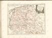
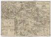
Der Dramburgsche Creis
1 : 296000 Drawsko Pomorskie (Polsko) Sotzmann, Daniel Friedrich
Tempelburg 37, uit: Special-Karte von Mittel-Europa / nach amtlichen Quellen bearbeitet von W. Liebenow
1 : 300000 titelvariant: W. Liebenow's Mittel-Europa; Annotatie: Titel boven de bladen: W. Liebenow's Mittel-Europa Johannes Wilhelm Liebenow 1822-1897 Frankfurt a. M. : Ludwig Ravenstein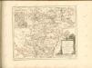

Composite: 124. Schivelbein. (Germany)
1 : 100000 Reichsamt fur Landesaufnahme
124. Schivelbein. (Germany)
1 : 100000 Reichsamt fur Landesaufnahme
Meßtischblatt 2560 : Zamzow, 1936
1 : 250000 Zamzow. - Hrsg. 1892, einz. Nachtr. 1899, gedr. [19]36. - 1:25000. - [Berlin]: Reichsamt für Landesaufnahme, 1936. - 1 Kt.
Meßtischblatt 2559 : Nörenberg, 1939
1 : 250000 Nörenberg. - Aufn. 1890, hrsg. 1892, mehrfarb. hrsg. 1939. - 1:25000. - [Berlin]: Reichsamt für Landesaufnahme, 1939. - 1 Kt.
Meßtischblatt 1154 : Freienwalde, 1892
1 : 250000 Freienwalde. - Aufn. 1890. - 1:25000. - [Berlin]: Reichsamt für Landesaufnahme, 1892. - 1 Kt.
Composite: 189. Norenberg. (Germany)
1 : 100000 Reichsamt fur Landesaufnahme
Meßtischblatt 2361 : Wusterwitz, 1936
1 : 250000 Wusterwitz. - Hrsg. 1911, bericht. 1936. - 1:25000. - [Berlin]: Reichsamt für Landesaufnahme, 1936. - 1 Kt.
Meßtischblatt 1065 : Zülshagen, 1911
1 : 250000 Zülshagen. - Aufn. 1875, hrsg. 1877, einz. Nachtr. 1911. - 1:25000. - [Berlin]: Reichsamt für Landesaufnahme, 1877. - 1 Kt.
158. Tempelburg. (Germany)
1 : 100000 Reichsamt fur Landesaufnahme
Meßtischblatt 872 : Reinfeld, 1936
1 : 250000 Reinfeld. - Aufn. 1889, bericht. 1936. - 1:25000. - [Berlin]: Reichsamt für Landesaufnahme, 1936. - 1 Kt.
MARCHIONATUS | BRANDENBURGICI | PARTES DUÆ, | NOVA MARCHIA | et | UCKERANA
Auctore | OLAO JOANNIS GOTHO | Gustaui Magni Cosmographo. [Amsterdam : Joan Blaeu]
Sect. 9: Stettin, uit: Geologische Karte des Deutschen Reichs in 27 Blaettern / [von] Richard Lepsius ; Red. von C. Vogel
1 : 500000 Annotatie: Blad 18 ontbreekt; Een aantal bladen op linnen; Een aantal bladen gereviseerd 1913-1914; Annotatie geografische gegevens: Met schaalstokken o.a. in kilometers; Legenda Carl Vogel 1828-1897 Gotha : Justus Perthes