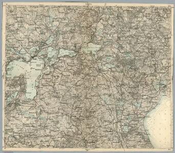
Maps of Großer Plöner See

Composite: 83. Eutin. (Germany)
1 : 100000 Reichsamt fur Landesaufnahme
83. Eutin. (Germany)
1 : 100000 Reichsamt fur Landesaufnahme
Meßtischblatt 577 : Süsel, 1886
1 : 250000 Süsel. - Aufn. 1877, hrsg. 1879, einz. Nachtr. 1886. - 1:25000. - [Berlin]: Reichsamt für Landesaufnahme, 1886. - 1 Kt.
Meßtischblatt 576 : Ahrensbök, 1888
1 : 250000 Ahrensbök. - Aufn. 1877, hrsg. 1879, einz. Nachtr. 1888. - 1:25000. - [Berlin]: Reichsamt für Landesaufnahme, 1888. - 1 Kt.
Meßtischblatt 575 : Schlamersdorf, 1930
1 : 250000 Schlamersdorf. - Hrsg. 1879, einz. Nachtr. 1930. - 1:25000. - [Berlin]: Reichsamt für Landesaufnahme, 1930. - 1 Kt.
Meßtischblatt 500 : Neustadt (i. Holstein), 1928
1 : 250000 Neustadt (i. Holstein). - Hrsg. 1879, einz. Nachtr. 1928. - 1:25000. - [Berlin]: Reichsamt für Landesaufnahme, 1928. - 1 Kt.
Meßtischblatt 499 : Eutin, 1891
1 : 250000 Eutin. - Aufn. 1877, hrsg. 1879, einz. Nachtr. 1891. - 1:25000. - [Berlin]: Reichsamt für Landesaufnahme, 1891. - 1 Kt.
Meßtischblatt 498 : Plön, 1879
1 : 250000 Plön. - Aufn. 1877. - 1:25000. - [Berlin]: Reichsamt für Landesaufnahme, 1879. - 1 Kt.
Meßtischblatt 428 : Selent, 1919
1 : 250000 Selent. - Aufn. 1877, Nachtr. 1919. - 1:25000. - [Berlin]: Reichsamt für Landesaufnahme, 1919. - 1 Kt.
Meßtischblatt 429 : Lütjenburg, 1919
1 : 250000 Lütjenburg. - Aufn. 1877, Nachtr. 1919. - 1:25000. - [Berlin]: Reichsamt für Landesaufnahme, 1919. - 1 Kt.
Meßtischblatt 430 : Hansühn, 1879
1 : 250000 Hansühn. - Aufn. 1877. - 1:25000. - [Berlin]: Reichsamt für Landesaufnahme, 1879. - 1 Kt.
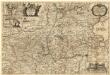
Wagria quae est Pars Orientalis Holsatiae
1 : 190000 Mollova mapová sbírka Janssonius, Johannes Schenk, Peter I
24. Eutin, uit: Topographische Uebersichtskarte des Deutschen Reiches / herausgegeben v. d. Kartogr. Abt. d. Königl. Preuß. Landesaufnahme
1 : 200000 titelvariant: Topogr. Übersichtskarte des Deutschen Reiches; Annotatie: Titel boven bladen ook: Topogr. Übersichtskarte des Deutschen Reiches; Annotatie geografische gegevens: Op elk blad twee maatstokken: 10 Kilometer = 5,5 cm; 1 geogr. Meile = 3,6 cm; Legenda onder op elk blad Königlich Preußische Landesaufnahme. Kartographische Abtheilung [S.l : Königlich Preußische Landesaufnahme, Kartographische Abtheilung]
WAGRIÆ | PARS SEPTENTRIONALIS | cum præfectura | CISMAR et OLDENBVRGH.
Christian Lorensen | Rodtgiesser sculps. [Amsterdam : Joan Blaeu]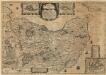
Wagriae Pars Septentrionalis cum praefectura Cismar et Oldenbvrgh
1 : 130000 Mollova mapová sbírka Mejer, Johannes Rothgiesser, Christian Lorenzen Blaeu, Joan I.
Ostsee
1 : 50000 Lübeck (Německo : oblast) Reichs-Marine-Amt
Meßtischblatt 578 : Rettin, 1879
1 : 250000 Rettin. - Aufn. 1877. - 1:25000. - [Berlin]: Reichsamt für Landesaufnahme, 1879. - 1 Kt.
Meßtischblatt 501 : Grömitz, 1889
1 : 250000 Grömitz. - Aufn. 1877, hrsg. 1879, einz. Nachtr. 1889. - 1:25000. - [Berlin]: Reichsamt für Landesaufnahme, 1889. - 1 Kt.
Meßtischblatt 431 : Oldenburg (in Holstein), 1930
1 : 250000 Oldenburg (in Holstein). - Hrsg. 1879, einz. Nachtr. 1930. - 1:25000. - [Berlin]: Reichsamt für Landesaufnahme, 1930. - 1 Kt.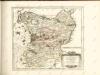

Wagria, quae est Pars Orientalis Holsatiae. [Karte], in: Novus atlas absolutissimus, Bd. 1, S. 149.
1 Karte aus Atlas Janssonius Offizin
WAGRIA, | que est | PARS ORIENTALIS | HOLSATIÆ.
Matthias & Nicolaus Peters | Goltschmide gebr. Hus. sculpst. [Amsterdam : Joan Blaeu]

[Herzogthum Holstein und Lauenburg, Fürstenthum Lübeck, Fr. Städte Hamburg und Lübeck nebst Amt Bergedorf]
Grosser Hand-Atlas über alle Theile der Erde in 170 Karten Meyer, J. Verlag des Bibliographischen Instituts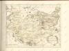

Holstein, Lauenburg, Lubeck, Hamburg.
1 : 440000 Meyer, Joseph, 1796-1856
PARS MERIDIONALIS | WAGRIÆ, | cum partes | STORMARIÆ | in qua Episcopatus Lubencensis, | Plona Principatus, et Præfectura | Segebergensis
Andres Lorensen | Rothgiesser Hus. | sculps. [Amsterdam : Joan Blaeu]
Das oestliche Holstein
Landtcarte Uom Süderntheil des Wagerland's
1 : 130000 Mollova mapová sbírka Mejer, Johannes Rothgiesser, Andreas Lorenzen