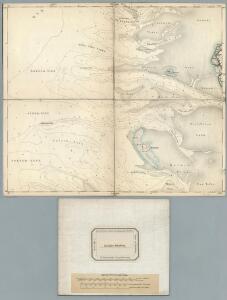
Maps of Vollerwiek

79. Eider-Mundung. (Germany)
1 : 100000 Reichsamt fur Landesaufnahme
Composite: 79. Eider-Mundung. (Germany)
1 : 100000 Reichsamt fur Landesaufnahme
Meßtischblatt 417, neue Nr. 1717 : Böhl (Kreis Husum-Eiderstedt), 1936
1 : 250000 Böhl (Kreis Husum-Eiderstedt). - Hrsg. 1880, bericht. 1928. - 1:25000. - [Berlin]: Reichsamt für Landesaufnahme, 1936. - 1 Kt.
Meßtischblatt 488 : Blauort, 1880
1 : 250000 Blauort. - Aufn. 1878. - 1:25000. - [Berlin]: Reichsamt für Landesaufnahme, 1880. - 1 Kt.
Meßtischblatt 418 : Vollerwiek, 1916
1 : 250000 Vollerwiek. - Aufn. 1878, hrsg. 1880, Aufldr. 1916. - 1:25000. - [Berlin]: Reichsamt für Landesaufnahme, 1916. - 1 Kt.
Meßtischblatt 564/565 : Trischen, 1931
1 : 250000 Trischen. - Hrsg. 1880, bericht. 1931. - 1:25000. - [Berlin]: Reichsamt für Landesaufnahme, 1931. - 1 Kt.
22. Husum, uit: Topographische Uebersichtskarte des Deutschen Reiches / herausgegeben v. d. Kartogr. Abt. d. Königl. Preuß. Landesaufnahme
1 : 200000 titelvariant: Topogr. Übersichtskarte des Deutschen Reiches; Annotatie: Titel boven bladen ook: Topogr. Übersichtskarte des Deutschen Reiches; Annotatie geografische gegevens: Op elk blad twee maatstokken: 10 Kilometer = 5,5 cm; 1 geogr. Meile = 3,6 cm; Legenda onder op elk blad Königlich Preußische Landesaufnahme. Kartographische Abtheilung [S.l : Königlich Preußische Landesaufnahme, Kartographische Abtheilung]
55. Garding. (Germany)
1 : 100000 Reichsamt fur Landesaufnahme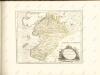

Tönning 20, uit: Special-Karte von Mittel-Europa / nach amtlichen Quellen bearbeitet von W. Liebenow
1 : 300000 titelvariant: W. Liebenow's Mittel-Europa; Annotatie: Titel boven de bladen: W. Liebenow's Mittel-Europa Johannes Wilhelm Liebenow 1822-1897 Frankfurt a. M. : Ludwig Ravenstein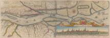
Nobilis Fluvius Albis maximâ curâ, ex variis famosisque Autoribus collectus, et in lucem editus. [Karte, Teil 2], in: Novus atlas absolutissimus, Bd. 2, S. 33.
1 Karte aus Atlas Janssonius Offizin
Tönning 20, uit: [W. Liebenow's Special-Karte von Mittel-Europa]
1 : 300000 titelvariant: W. Liebenow's Mittel-Europa; Annotatie: Titel boven de bladen: W. Liebenow's Mittel-Europa Johannes Wilhelm Liebenow 1822-1897 Hannover : Hermann Oppermann
Nobilis Fluvius Albis maximâ curâ, ex variis, famosisque Autoribus collectus, et in lucem editus. [Karte, Teil 2], in: Gerardi Mercatoris et I. Hondii Newer Atlas, oder, Grosses Weltbuch, Bd. 1, S. 277.
1 Karte aus Atlas Mercator, Gerhard und Hondius, Jodocus Jansson, Jan
Nordsee
1 : 50000 Cuxhaven (Německo) Reichs-Marine-Amt
Thietmarsiae, Hosaticae Regionis Partis Typvs
1 : 200000 Mollova mapová sbírka Boekel, Peter
DITHMARSIÆ | PARS SEPTENTRIONALIS [...]
author Iohannes Mejer Husum. | Regæ. Majis. Mathematicus Matthis Pet. v Clauß Peterss Goldtschmide unt gb. Hus. Cimbr. sculp. [Amsterdam : Joan Blaeu]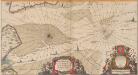
Nobilis Saxoniae Fl. Visurgis, cum Terris adjacentib. Ab Inclyta Brema, ad ostium maris. [Karte, Teil 2], in: Novus atlas absolutissimus, Bd. 2, S. 100.
1 Karte aus Atlas Janssonius Offizin
[left] DITHMARSIÆ | TABVLA; [right] DITHMARSIÆ | TABVLA
Auctore Joh: Meyer Husumensi | Anno 1559 Matthias & Nicolaus Peters | Goldtschmide gebr. Hus. sculps. [Amsterdam : Joan Blaeu]
Composite: 55. Garding. (Germany)
1 : 100000 Reichsamt fur Landesaufnahme
Gluckstatt mitt dero Gegend Westwerth und von daar die Elbe vollend hinnab zufahren bis in die Westsee, sampt dem Hamburgischen Ampt Ritzbuttel.
1 : 310000 Mollova mapová sbírka Bodenehr, Gabriel Bodenehr, Gabriel
DITHMARSIÆ | PARS AVSTRALIS.
Authore Iohannes Mejer, Husum Reg.e Maj.is | Mathematicus Matthias und Nicolaus Peters Goldts. gebr. Hus. sculps. [Amsterdam : Joan Blaeu]
Dithmarsiae Tabvla
1 : 150000 Mollova mapová sbírka Mejer, Johannes Peters, Matthias Blaeu, Joan I.
Dithmarsiae Tabvla
1 : 150000 Mollova mapová sbírka Mejer, Johannes Peters, Matthias Blaeu, Joan I.
80. Heide. (Germany)
1 : 100000 Reichsamt fur Landesaufnahme
TERRITORIA | EIJDERSTEDE | Everschop | et | Uthholm.
Matthias und Nicolaus Pet. Goldtschmide gebr. | Husum. sculps. [Amsterdam : Joan Blaeu]
Meßtischblatt 1617, 1618 : Übersichtskarte des Hermann-Göring-Kooges, 1935
1 : 250000 Übersichtskarte des Hermann-Göring-Kooges. - Hrsg. 1935. - 1:25000. - [Berlin]: Reichsamt für Landesaufnahme, 1935. - 1 Kt.
Ducatus Slevicensis Australis Pars. [Karte], in: Novus atlas absolutissimus, Bd. 1, S. 161.
1 Karte aus Atlas Janssonius Offizin
Ducatus Holsatiæ descriptio novissima / excudebant Janssonio-Waesbergii et Moses Pitt
1 : 365000 Annotatie: Origineel is Blad 82 in atlas factice; Annotatie geografische gegevens: Schaalstok: Die Maße der Teutsche Meilln, 3=5,9 cm; Rechtsboven: XLI Johannes Janssonius van Waesberge -1681?; Moses Pitt ca. 1654-1696 [Amstelodami : apud Ioannem Ianssonium]
NOVA & ACCVRATISSIMA | DVCATVS | HOLSATIÆ | TABVLA
Auctore Joh. Meyer Husumensi. Matthias Und Clauß Petersen Goldtschmide gebr. Hus. sculps. [Amsterdam : Joan Blaeu]