Maps of Pravdinsky District

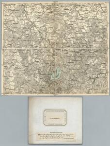
76. Nordenburg. (Germany)
1 : 100000 Reichsamt fur Landesaufnahme
Composite: 76. Nordenburg. (Germany)
1 : 100000 Reichsamt fur Landesaufnahme
Meßtischblatt 1695 : Nordenburg, 1943
1 : 250000 Nordenburg. - Aufn. 1927, hrsg. 1933, letzte Nachtr. 1939. - 1:25000. - [Berlin]: Reichsamt für Landesaufnahme, 1943. - 1 Kt.
Meßtischblatt 1694 : Wandlacken, 1942
1 : 250000 Wandlacken. - Aufn. 1927, hrsg. 1933, letzte Nachtr. 1939. - 1:25000. - [Berlin]: Reichsamt für Landesaufnahme, 1942. - 1 Kt.
Meßtischblatt 1938 : Kanitz, 1938
1 : 250000 Kanitz. - Aufn. 1927, letzte Nachtr. 1932, hrsg. 1934, red. - 1:25000. - [Berlin]: Reichsamt für Landesaufnahme, 1938. - 1 Kt.
Meßtischblatt 1595 : Bokellen, 1932
1 : 250000 Bokellen. - Hrsg. 1927, einz. Nachtr. 1927. - 1:25000. - [Berlin]: Reichsamt für Landesaufnahme, 1932. - 1 Kt.
Meßtischblatt 1594 : Kleingnie, 1938
1 : 250000 Kleingnie. - Hrsg. 1927, redakt. Änd. 1938. - 1:25000. - [Berlin]: Reichsamt für Landesaufnahme, 1938. - 1 Kt.
Meßtischblatt 1596 : Schwalbental, 1943
1 : 250000 Schwalbental. - Aufn. 1927, hrsg. 1933, letzte Nachtr. 1939. - 1:25000. - [Berlin]: Reichsamt für Landesaufnahme, 1943. - 1 Kt.
Sect. 16. Nordenburg (Das alte Land Barten), uit: Geologische Karte der Provinz Preussen
1 : 100000 Annotatie: Incompleet; Voor aanwezige bladen zie bladoverzicht; Met inzetkaarten; Annotatie geografische gegevens: Coördinaten gebaseerd op nulmeridiaan van Ferro (Hierro) Berlin : Neumann
Meßtischblatt 1796 : Angerburg, 1938
1 : 250000 Angerburg. - Aufn. 1923, hrsg. 1927, redakt. Änd. 1938. - 1:25000. - [Berlin]: Reichsamt für Landesaufnahme, 1938. - 1 Kt.
Meßtischblatt 1795 : Drengfurth, 1938
1 : 250000 Drengfurth. - Aufn. 1914/1924, hrsg. 1927, redakt. Änd. 1938. - 1:25000. - [Berlin]: Reichsamt für Landesaufnahme, 1938. - 1 Kt.
Meßtischblatt 1794 : Barten, 1936
1 : 250000 Barten. - Hrsg. 1926. - 1:25000. - [Berlin]: Reichsamt für Landesaufnahme, 1936. - 1 Kt.
Insterburg u. Gumbinnen 18, uit: Special-Karte von Mittel-Europa / nach amtlichen Quellen bearbeitet von W. Liebenow
1 : 300000 titelvariant: W. Liebenow's Mittel-Europa; Annotatie: Titel boven de bladen: W. Liebenow's Mittel-Europa Johannes Wilhelm Liebenow 1822-1897 Frankfurt a. M. : Ludwig Ravenstein
Schlacht an den Masurischen Seen
1 : 1000000 Masuren Schlacht, Weltkrieg <1914-1918>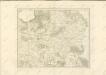

Composite: 77. Goldap. (Germany)
1 : 100000 Reichsamt fur Landesaufnahme
77. Goldap. (Germany)
1 : 100000 Reichsamt fur Landesaufnahme
Plan de la bataille de Jaegerndorf
Schley, Jacobus van der Hondt, Pierre de Pierre de Hondt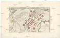
Plan der bey Gross-Jägerndorf, den 30 Augusti A.o 1757 zwischen denen kayser. russischen und könig. preussischen Armeen vorgefallen Bataille
auf Kosten der Raspischen Buchhandlung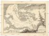
Bataille de Gros-Jaegerndorf, en Prusse, gagnée par l'armée russe, aux ordres du feldmaréchal d'Apraxin, sur les troupes prussienes commandées par le feldmaréchal de Lewald, le 30. aout, 1757
1 : 40000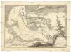
Bataille de Gros-Jaegerndorf, en Prusse, gagnée par l'armée russe, aux ordres du feldmaréchal d'Apraxin, sur les troupes prussienes commandées par le feldmaréchal de Lewald, le 30. aout, 1757
1 : 40000
Meßtischblatt1494 : Muldschen, 1936
1 : 250000 Muldschen. - Aufn. 1924, hrsg. 1927. - 1:25000. - [Berlin]: Reichsamt für Landesaufnahme, 1936. - 1 Kt.
Meßtischblatt 1495 : Schulzenhof, 1939
1 : 250000 Schulzenhof. - Hrsg. 1928, redakt. Änd. 1939. - 1:25000. - [Berlin]: Reichsamt für Landesaufnahme, 1939. - 1 Kt.
Meßtischblatt 1496 : Jänichen, 1939
1 : 250000 Jänichen. - Aufn. 1924, hrsg. 1928. - 1:25000. - [Berlin]: Reichsamt für Landesaufnahme, 1939. - 1 Kt.
Meßtischblatt 1597 : Ballethen, 1942
1 : 250000 Ballethen. - Aufn. 1927, hrsg. 1934, letzte Nachtr. 1939. - 1:25000. - [Berlin]: Reichsamt für Landesaufnahme, 1942. - 1 Kt.
Meßtischblatt 1697 : Gr. Sobrost, 1939
1 : 250000 Gr. Sobrost. - Aufn. 1927, hrsg. 1934, letzte Nachtr. 1939. - 1:25000. - [Berlin]: Reichsamt für Landesaufnahme, 1939. - 1 Kt.
Meßtischblatt 1693 : Gerdauen, 1938
1 : 250000 Gerdauen. - Hrsg. 1915, einz. Nachtr. 1928, redakt. Änd. 193. - 1:25000. - [Berlin]: Reichsamt für Landesaufnahme, 1938. - 1 Kt.
Meßtischblatt 1593 : Allenburg, 1942
1 : 250000 Allenburg. - Aufn. 1913, hrsg. 1915, bericht. 1922, letzte Na. - 1:25000. - [Berlin]: Reichsamt für Landesaufnahme, 1942. - 1 Kt.