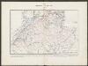
Maps of Kolding Municipality

Composite: 7. Hadersleben. (Germany)
1 : 100000 Reichsamt fur Landesaufnahme
7. Hadersleben. (Germany)
1 : 100000 Reichsamt fur Landesaufnahme
Meßtischblatt 25 : Aller, 1879
1 : 250000 Aller. - Aufn. 1877. - 1:25000. - [Berlin]: Reichsamt für Landesaufnahme, 1879. - 1 Kt.
Meßtischblatt 24 : Christiansfeld, 1879
1 : 250000 Christiansfeld. - Aufn. 1877. - 1:25000. - [Berlin]: Reichsamt für Landesaufnahme, 1879. - 1 Kt.
PARS ORIENTALIS | PRÆFECTVRÆ | HADERSLEBEN | Vulgo dictæ Baringsijßel.
Matthias Vnd Clauss Petersen | G.S. gebr. | Husumenss. sculps. [Amsterdam : Joan Blaeu]
Kolding nach der Schlacht

Meßtischblatt 39 : Grarup, 1879
1 : 250000 Grarup. - Aufn. 1877. - 1:25000. - [Berlin]: Reichsamt für Landesaufnahme, 1879. - 1 Kt.
Meßtischblatt 38 : Hadersleben, 1879
1 : 250000 Hadersleben. - Aufn. 1877. - 1:25000. - [Berlin]: Reichsamt für Landesaufnahme, 1879. - 1 Kt.
Meßtischblatt 40 : Aarö, 1879
1 : 250000 Aarö. - Aufn. 1877. - 1:25000. - [Berlin]: Reichsamt für Landesaufnahme, 1879. - 1 Kt.
4. hadersleben, uit: Topographische Uebersichtskarte des Deutschen Reiches / herausgegeben v. d. Kartogr. Abt. d. Königl. Preuß. Landesaufnahme
1 : 200000 titelvariant: Topogr. Übersichtskarte des Deutschen Reiches; Annotatie: Titel boven bladen ook: Topogr. Übersichtskarte des Deutschen Reiches; Annotatie geografische gegevens: Op elk blad twee maatstokken: 10 Kilometer = 5,5 cm; 1 geogr. Meile = 3,6 cm; Legenda onder op elk blad Königlich Preußische Landesaufnahme. Kartographische Abtheilung [S.l : Königlich Preußische Landesaufnahme, Kartographische Abtheilung]
4. Hadersleben (papieren versie, niet op linnen), uit: Topographische Uebersichtskarte des Deutschen Reiches / herausgegeben v. d. Kartogr. Abt. d. Königl. Preuß. Landesaufnahme
1 : 200000 titelvariant: Topogr. Übersichtskarte des Deutschen Reiches; Annotatie: Titel boven bladen ook: Topogr. Übersichtskarte des Deutschen Reiches; Annotatie geografische gegevens: Op elk blad twee maatstokken: 10 Kilometer = 5,5 cm; 1 geogr. Meile = 3,6 cm; Legenda onder op elk blad Königlich Preußische Landesaufnahme. Kartographische Abtheilung [S.l : Königlich Preußische Landesaufnahme, Kartographische Abtheilung]
Special-Karte von Nord-Schleswig im Maassstabe 1:150.000
1 : 150000 Fredericia (Dánsko) Petermann, August Justus Perthes
Special-Karte von Nord-Schleswig im Maassstabe 1:150.000
1 : 150000 Fredericia (Dánsko) Petermann, August Friedrich Ehrlich
DVCATVS | SLESWICI | PARS BOREALIS.
Matthias und Nicolaus Pet. | Goldtschmide gebr. Hus. sculp. [Amsterdam : Joan Blaeu]
Ducatus Slesvicensis Pars Septentrionalis. [Karte], in: Novus atlas absolutissimus, Bd. 1, S. 158.
1 Karte aus Atlas Janssonius Offizin
Sonderburg 11, uit: Special-Karte von Mittel-Europa / nach amtlichen Quellen bearbeitet von W. Liebenow
1 : 300000 titelvariant: W. Liebenow's Mittel-Europa; Annotatie: Titel boven de bladen: W. Liebenow's Mittel-Europa Johannes Wilhelm Liebenow 1822-1897 Frankfurt a. M. : Ludwig Ravenstein
Fionia
1 Karte : Kupferdruck ; 34 x 38 cm Mercator; Hondius Henricus Hondius
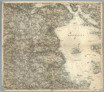
Topographische Karte der Umgegend von Fredericia
1 : 160000 Fredericia (Dánsko) C. Flemming
Plan der Gegend von Friedericia
1 : 50000 Liebenow, Wilhelm Schropp
Die Festung Fredericia
1 : 70000 Fredericia (Dánsko) Brüder Bohm
Special-Karte der Gegend zwischen Kolding, Veile, Fredericia in 1:75,000 und Plan der Festung Fredericia mit Umgegend in 1:25,000
1 : 75000 Doemming, F. v. Neumann
Meßtischblatt 23 : Jels, 1880
1 : 250000 Jels. - Aufn. 1878. - 1:25000. - [Berlin]: Reichsamt für Landesaufnahme, 1880. - 1 Kt.
Meßtischblatt 16 : Skudstrup, 1880
1 : 250000 Skudstrup. - Aufn. 1878. - 1:25000. - [Berlin]: Reichsamt für Landesaufnahme, 1880. - 1 Kt.
Een gedeelte van de Beldt Zee vertoonende desselfs Westelijkste zeekusten int grood bestek
Denmark Gerard van Keulen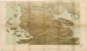
Das Herzongthum Schleswig

Schleswig.
1 : 427000 Gotthard, A.
Fionia [Karte], in: Gerardi Mercatoris et I. Hondii Newer Atlas, oder, Grosses Weltbuch, Bd. 1, S. 112.
1 Karte aus Atlas Mercator, Gerhard und Hondius, Jodocus Jansson, Jan