Maps of Costa Rica
A Map of the British Empire in America. (Sheet 18).
1 : 2000000 Popple, Henry
A new map of Central America shewing the different lines of Atlantic and Pacific communication
1 : 2982000 Disturnell, John, 1801-1877 J. Disturnell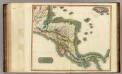
Spanish N. America, S. pt.
1 : 2800000 Thomson, John
Spanish North America, southern part
1 : 2800000
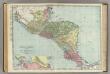
Central America. Guatemala, Honduras, Nicaragua, Costa Rica and Jamaica.
1 : 5500000 Colton, G.W.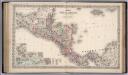
Central America.
1 : 3800000 Colton, G.W.
Central America.
1 : 5500000 Colton, G.W.
Central America.
1 : 5200000 Colton, G.W.
Central America.
1 : 5500000 Colton, G.W.
Central America.
1 : 5248000 Johnson, A.J.
Central America. Guatemala, Honduras, Nicaragua, Costa Rica and Jamaica.
1 : 5500000 Colton, G.W.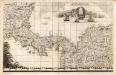
A Map of the British Empire in America. (Sheet 18).
1 : 2000000 Popple, Henry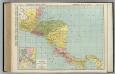
Central America.
1 : 2648000 Rand McNally and Company
Central America.
1 : 5600000 Schlitz Brewing Company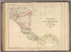
Central America.
1 : 3453120 Rogers, Henry Darwin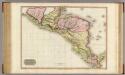
Spanish dominions in North America, southern part.
1 : 2400000 Pinkerton, John, 1758-1826
Nova Isthmi Americani, qui et Panamiensis item Dariensis Tabula
Solo algunos mapas impresos por los hermanos Reinier y Josua Ottens llevan su impronta. Para armar sus atlas, los Ottens solían simplemente copiar o reimprimir mapas de otros cartógrafos holandeses y franceses. Este mapa del Istmo de Panamá evidencia, en cambio, adaptaciones y mejoras significativas de los Ottens a la Carte Particuliere De Isthmus ou Darien publicada por Pierre Mortier en 1700, poniendo particular énfasis en las islas, islotes, cayos, bajos, arenas, etc., del litoral centroamericano, así como en el relieve y la hidrografía del istmo y del continente. Ottens, R. (Reinier) (1698-1750); Ottens, J. (Josua) (1704-1765).
Central America.
1 : 5385600 Johnson, A.J.
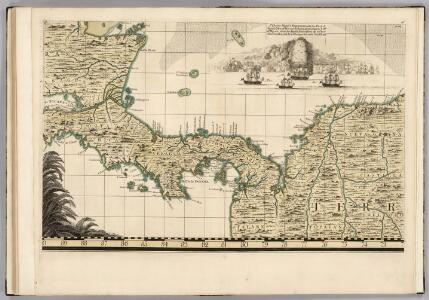
Nieuwen afteekening van de kust van Cartagena en Portobello beginnende van Santo Martha tot Rio Carabaca met allen desselfs havens baijen revieren eijlanden droogtens en dieptens Ao 1729
Panama Davelaar Johannes van Keulen
Map of Central America including the states of Guatemala, Salvador, Honduras, Nicaragua & Costa-Rica, the territories of Belise & Mosquito, with parts of Mexico, Yucatan & New Granada : shewing the proposed routes between the Atlantic & Pacific oceans by way of Tehuantepeque, Nicaragua & Panama
1 : 2100000 Baily, John, fl. 1811-1850 Saunders and Stanford
Central America.
1 : 5000000 Rand McNally and Company
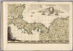
De kust van Carthagena, Tierra Firma, Costa Rica en de Honduras van Rio Grande de St. Martha tot Baija Honda int groot
Panama Gerard van Keulen
Central America
1 : 3800000 Mitchell, Samuel Augustus
Central America
1 : 3800000 Mitchell, Samuel Augustus
Carte Particuliere De Isthmus, Ou Darien, Qui comprend le Golfe De Panama &c. Cartagene, et les Isles Aux Environs. [Karte], in: Atlas nouveau, contenant toutes les parties du monde [...], Bd. 2, S. 243.
1 Karte aus Atlas Sanson, Nicolas Jaillot, Alexis Hubert und Mortier, Pieter
Guatemala
Guatemala im Verlage des Geographischen Instituts
Terra Firma et Novum Regnum Granatense et Popayan
Johannes Janssonius (1588 – 1664) fue, junto con su rival Willem Janzoon Blaeu (1571-1638), uno de los cartógrafos y editores de atlas más famosos de la llamada Edad de Oro Holandesa. Ambos cartógrafos, y los talleres cartográficos de sus familias, rivalizaron en la producción de los más completos y lujosos atlas de su tiempo, aprovechando el amplio material cartográfico producido y recolectado por las exploraciones y colonizaciones holandesas alrededor del mundo. Para este mapa Janssonius usó – al igual que su rival Blaeu- el mapa originalmente publicado en 1625 por Hessel Gerritz (1580-1632) importante cartógrafo, que había sido hidrógrafo de la Compañía Holandesa de Indias Orientales y de la no menos imperial Compañía Holandesa de Indias Occidentales. El poderío naval de estas Compañías durante el siglo XVII le permitió a Holanda arrebatarle algunas posesiones de Portugal y España en América, África y Asia. En el Caribe, y muy cerca de la costa venezolana y de la península de la Guajira, Holanda tomó posesión de las islas de Curazao, Aruba y Bonaire. Desde esas islas los holandeses atacaban fácilmente a las flotas españolas y controlaban el contrabando de esclavos africanos en el Caribe. El control de estas islas por los holandeses fue resultado, también, de la extensión Al Nuevo Mundo de la guerra entre Holanda y España ("Guerra de Flandes" o “Guerra de los Ochenta Años” 1568-1648). Este mapa –que incluye las islas de Aruba y Curazao nos muestra el gran conocimiento que los holandeses tenían a principios del siglo XVII sobre el territorio español en América. Janssonius, Jan (1588-1664) Gerritsz, Hessel (1580-1632)
Terra Firma et Novum Regnum Granatense et Popayan. [Karte], in: Theatrum orbis terrarum, sive, Atlas novus, Bd. 2, S. 338.
1 Karte aus Atlas Blaeu, Joan Blaeu, Willem Janszoon
Central America. Dominion of Canada and Newfoundland.
1 : 4440000 Hammond, C.S.