Maps of France
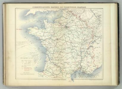
Communications Rapie du Territoire Francais.
Jouvet et Cie.
France
A new general atlas of modern geography, consisting of a complete collection of maps of the four quarters of the globe Wyld, James James Wyld
Frankreich von 1461 bis 1610.
1 : 3800000 Spruner von Merz, Karl
Carte géologique de la France 1/1 000 000
1 : 1000000 Francie Beranger, Charles Ministere des Travaux publics
Accuratissima Galliae tabula vulgo royaume de France
1 : 2400000 Francie Danckerts, Justus I. Danckerts
Frankreich von 1180 bis 1461, Zeitraum der Albigenser- und englischen Kriege.
1 : 3800000 Spruner von Merz, Karl
Carte elémentaire de la navigation du royaume
1 Karte : Kupferdruck ; 46 x 70 cm Fer de la Nouerre; Dupuis chez l'auteur rue Guénégaud n.o 30
Postcharte von Franckreich auf das Iahr 1787
1 Karte : Kupferdruck ; 62 x 61 cm Jaillot s.n.
Carte des postes de France pour l'année 1783
1 Karte : Kupferdruck ; 63 x 63 cm Desnos; Jaillot chez Desnos ingénieur-géographe et libraire de Sa Majesté danoise rue St. Jacques au globe et à la sphére
Carte du royaume de France où sont tracées exactement les routes des postes
1 Karte : Kupferdruck ; 46 x 50 cm Robert de Vaugondy; Haussard s.n.
Frankreich.
1 : 2400000 Stein, Christ. Gottfr. Dan.
Nouvelle carte de France
Francie Audin Audin
France Historique.
Andriveau-Goujon, J.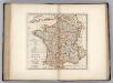
France Divided into Circles and Departments.
1 : 3300000 Carey, Mathew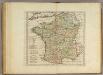
France Divided into Circles and Departments.
1 : 3300000 Carey, Mathew
France Divided into Circles and Departments.
1 : 3421440 Carey, Mathew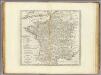
France Divided into Circles and Departments.
1 : 3484800 Carey, Mathew
France Divided into Circles and Departments.
1 : 3484800 Carey, Mathew
France, departments.
1 : 10000000 Fenner, Rest.
France, provinces.
1 : 10000000 Fenner, Rest.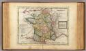
France.
1 : 5000000 Moll, Herman, d. 1732
Frankreich's aeltere kirchliche Eintheilung bus zum Jahre 1322.
1 : 3800000 Spruner von Merz, Karl
France.
1 : 3500000 Schonberg & Co.
France.
1 : 3350000 Mitchell, Samuel Augustus
France.
1 : 3350000 Mitchell, Samuel Augustus
France.
1 : 3350000 Mitchell, Samuel Augustus Jr.
Regnum Galliae moderna
1 : 8760000 Francie
[Frankreich]
Francie
Les routes exactes des postes du royaume de France
1 : 2500000 Francie Seutter, Matthäus Lotter, Tobias Conrad Tob. Conr. Lotter
Les routes exactes des postes du royaume de France
1 : 2500000 Francie Lotter, Tobias Conrad Seutter, Matthäus Matth. Seutter