Maps of Czech Republic

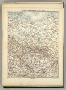
Europe Centrale (Partie Centrale).
1 : 1750000 Jouvet et Cie.
Atlas für Handel und Industrie: Für Kaufleute, Fabrikante u. Gewerbetreibende, Handlungs- u. Gewerbe-Schulen


[Polsko]
Polsko
[Polsko]
Polsko
Bojiště válek husitských v letech 1419-1434 : do bitvy u Lipan 30. května 1434
1 : 1500000 Evropa střední Kuffner, Hanuš Wagner, Jan Eduard R. Prombergr
Posádky v Zemích koruny české a v zemích zahraničních
1 : 1500000 Evropa střední Kuffner, Hanuš Wagner, Jan Eduard nákladem R. Prombergra
Deutchland

Karte des Central-Kriegsschauplatzes in Deutschland
1 : 2000000 Evropa střední Eduard Hölzel
Graphische Karte der Verfrachtungen Böhmischen Braunkohlen
1 : 1290000 Čechy (Česko) Pollack, Richard Aussig-Teplitzer Eisenbahn-Direction
Germania Ptolemaei
1 : 3600000 Mollova mapová sbírka Weigel, Christoph Weigel, Christoph I.
Übersichts-Karte des Donau-Moldau-Elbe-Canals
1 : 1250000 Dunaj (řeka : povodí)
Norddeutsche Bundesstaaten
Evropa střední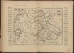
Říše Česká za Karla IV
Tschechische Republik Polen Böhmen Karl IV.
NO Deutschland.
1 : 5500000 Brudin, J. L.; Stieler, Adolf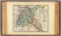
The N.E. part of Germany.
1 : 3500000 Moll, Herman, d. 1732
Circuli Austriaci Pars Occidentalior, Comprehendens Comitatum Principalem Tirolis Episcopatus Tridentinum et Brixensem Comitatus Brigantinum Feldkirchiae Sonnebergae Pluentii etc.
1 : 558000 Mollova mapová sbírka Wit, Frederik de Wit, Frederick
Charte des gegenwärtigen Kriegs in Teutschland ou la Guerre presente
1 : 2800000 Mollova mapová sbírka Friedrich, Jacob Andreas Frédéric, Jacques-André
Charte des gegenwärtigen Kriegs in Teutschland ou la Guerre presente
1 : 2800000 Mollova mapová sbírka Friedrich, Jacob Andreas Frédéric, Jacques-André
Norddeutsche Bundesstaaten
Evropa střední
Nord-Ostliches Deutschland bearbeitet von C. Vogel.
1 : 1850000 Vogel, C.
NE pt. of Germany.
1 : 3150000 Bowen, Emanuel
[Poštovní mapa]
Evropa střední Schwarz, Wenzel Koch, Josef Wenzl Schwarz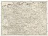
[Poštovní mapa střední Evropy]
Evropa střední Schwarz, Wenzel Koch, Josef Wenzl Schwarz
Post-Karte
Evropa střední Schwarz, Wenzel Koch, Josef Wenzl Schwarz
The N. E. Part of Germany
1 : 3400000 Mollova mapová sbírka Moll, Herman Moll, Hermann
Polen u. Nachbarländer 963 bis 992
1 : 12000000 Polen
Sbírka map a diagramů použitých na mírových konferencích v Paříži v letech 1919 - 1920