Maps of Seven Seas (Open Ocean)

Oceanica, Sandwich Islands.
1 : 70000000 Mitchell, Samuel Augustus
Oceanica, Sandwich Islands.
1 : 70000000 Mitchell, Samuel Augustus
Oceanica, Sandwich Islands.
1 : 70000000 Mitchell, Samuel Augustus Jr.
Oceanica, Sandwich Islands.
1 : 70000000 Mitchell, Samuel Augustus
Oceanica, Sandwich Islands.
1 : 70000000 Mitchell, Samuel Augustus
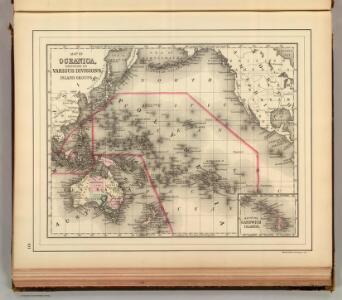
Map Of Oceanica.
1 : 100000000 Mitchell, Samuel Augustus
Africa
1 : 6500000 Arrowsmith, Aaron, 1750-1823 A. Arrowsmith, Rathbone Place
Pacific Ocean
1 : 35000000 Aleutské ostrovy (Aljaška) National Geographic Society
Grosser Ocean.
1 : 75000000 Andree, Richard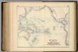
Oceania, or Islands in the Pacific Ocean.
1 : 41000000 Fullarton, A. & Co.
Pacific.
1 : 75000000 Andree, Richard; Times (London, England)
A chart of the discoveries made by the late Capt. Cook, & other European navigators, in the great Pacific Ocean between Asia and America
Kitchin, Thomas Baldwin, Richard
Pacific Ocean : compiled from Admiralty surveys & other official sources
1 : 15000000 India-Rubber, Gutta-Percha & Telegraph Works Co J.D. Potter
Oceana Or Pacific Ocean.
1 : 55000000 Tanner, Henry S.
Oceana Or Pacific Ocean.
1 : 55000000 Tanner, Henry S.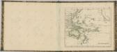

Magnum Mare del Zur cum insula California
1 Karte : Kupferdruck ; 49 x 55 cm Renard by L. Renard
Pacific Ocean.
1 : 50000000 Letts, Son & Co.
Oceana Or Pacific Ocean.
1 : 57500000 Mitchell, Samuel Augustus
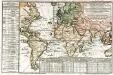
Longueurs du pendule.
1 : 75000000 L'Isle, Guillaume de, 1675-1726
Composite: Pacific Ocean.
1 : 25000000 John Bartholomew and Son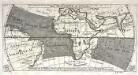
Réprésentation du cours ordinaire des vents de traverse qui regnent le long des côtes dans la mer Atlantique [et] celle des Indes
1 Karte : Kupferdruck ; 15 x 30 cm Cosmant Didot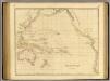
Pacific Ocean.
1 : 35000000 Arrowsmith, John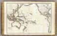
Oceanie.
1 : 29500000 Brue, Adrien Hubert, 1786-1832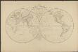
Mappemonde en deux hémisphères où sont tracées les lignes de faîte des grands bassins qui partagent la surface du globe
1 : 44000000 par L. Vivien gravé par Desbuisson [...] ; écrit par Arnoul Paris : Hachette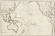
Composite: Oceanie.
1 : 15500000 Brue, Adrien Hubert, 1786-1832
Pacific Ocean including Oceania.
1 : 47000000 Mitchell, Samuel Augustus
Pacific Ocean including Oceania.
1 : 47000000 Mitchell, Samuel Augustus
Pacific Ocean.
1 : 90000000 Arrowsmith, Aaron; Lewis, Samuel