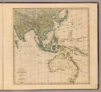
Maps of Australia

2. Atlas des ganzen Erdkreises.
1 : 61000000 Reichard, C. G.
Nieuwe kaart van Azië
1 : 12000000 Annotatie: Met afstandentabel (hemelsbreed) [S.l. : Zijlstra]
Carte à repérage Édé. n27, Asie - Océanie - Pacifique
1 : 17000000 Lille : Imprimerie industrielle
Oestlicher Planiglob der Erde [Tl.]
1 : 17000000 [...] vervollständigt und berichtiget von C.F. Weiland Weimar : Im Verlage des Geograph. Instituts
Far East, Mediterranean Area.
1 : 13000000 Sun Oil Company
標準大東亜分圖. 共荣圈全圖
1 : 27800000 標準大東亞分圖‧共荣圈全圖 昭和十八年[1943]7月25日再版,芹澤馨吾 製圖,东京:統政社株式會社 發行 此图演示日本大东亚共荣圈的空间范围,包含亚洲、大洋洲、太平洋和印度洋的广大地区。 1图,彩色,日文,图幅54.5 x 77.3 cm,比例尺1:27,800,000,经纬度约为E30°-W160°; S45°-N60°。 Harvard-YenchingManchuguo J-0831;Hollis Number:014623995 芹澤馨吾 統政社株式會社
[139][142] Orientaliora Indiarum orientalium ... Pascaert ... van Oost Indien, uit: Atlas sive Descriptio terrarum orbis
Annotatie: Gedigitaliseerde versie. Amsterdam. Heiloo : Picturae (vervaardiger), 2015. tiff-bestand. Gedigitaliseerd: 07-01-2015; Origineel: Universiteitsbibliotheek Vrije Universiteit (XL.05127.-) ; Netherlands; Titelpagina ontbreekt Wit, Frederik de Amsterdam : Frederick de Wit
Oosterdeel van Oost Indien [Karte], in: De Nieuwe Groote Vermeerderde Zee-Atlas ofte Water-Werelt, S. 59.
1 Karte aus Atlas Doncker, Hendrick
The islands of the East Indies with the channels between India, China & New Holland.
from Carey's general atlas, improved and enlarged : being a collection of maps of the world and quarters, their principal empires, kingdoms, &c.
[Indischer Ozean, östlicher Teil]
1 Karte : Kupferdruck ; 57 x 45 cm Doncker Hendrik Doncker
Indian Ocean cables, wireless stations.
1 : 40000000 Philip, George
India quae Orientalis dicitur, Et Insulae Adiacentes. [Karte], in: Le théâtre du monde, ou, Nouvel atlas contenant les chartes et descriptions de tous les païs de la terre, Bd. 2, S. 239.
1 Karte aus Atlas Blaeu, Willem Janszoon und Blaeu, Joan Blaeu, Willem Janszoon
Orientaliora Indiarum Orientalium cum insulis adjacentibus à promontorio C. Comorin ad Iapan
1 Karte : Kupferdruck ; 43 x 54 cm Renard Louis Renard
India quae Orientalis dicitur, et Insulae Adiacentes. [Karte], in: Novus Atlas, das ist, Weltbeschreibung, Bd. 2, S. 263.
1 Karte aus Atlas Blaeu, Joan Blaeu, Willem Janszoon
India quae Orientalis dicitur, Et Insulae Adiacentes. [Karte], in: Theatrum orbis terrarum, sive, Atlas novus, Bd. 2, S. 248.
1 Karte aus Atlas Blaeu, Joan Blaeu, Willem Janszoon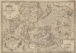
Indiae Orientalis, Insularumque Adiacientium Typus. [Karte], in: Theatrum orbis terrarum, S. 399.
1 Karte aus Atlas Ortelius, Abraham Vrients, Jan Baptista

INDIA | quæ | ORIENTALIS | dicitur | ET | INSVLÆ | ADIACENTES.
[Amsterdam : Joan Blaeu]
India quae Orientalis dicitur, et Insulae Adiacentes. [Karte], in: Novus atlas absolutissimus, Bd. 6, S. 144.
1 Karte aus Atlas Janssonius Offizin
China East Indies Australia And Oceanica.
1 : 22809600 Johnson, A.J.
Indian Ocean
1 : 20000000 Austrálie National Geographic Society

Ostindien mit den Inseln
Schul-Atlas über alle Theile der Erde nach dem neuesten Zustande, und über das Weltgebäude Stieler, Adolf Justus Perthes
Siam, Malacca and the Indian Islands.
from A new systeme of the mathematicks: containing I. Arithmetick, as well natural and decimal, as in species, or the principles of algebra. II. Practical geometry, together with the first six books of Euclid's Elements, as also the eleventh and twelfth, symbo

Tartariae sinensis mappa geographica

Indes, la Chine.
1 : 10700000 L'Isle, Guillaume de, 1675-1726
Indes, la Chine.
1 : 10700000 L'Isle, Guillaume de, 1675-1726
Buddhaistischen Staaten-Systems.
1 : 25000000 Flemming, Carl