Project
Community
News
My maps
Cataloged map
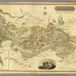
Stirlingshire.
Full title:
Stirlingshire.
Publisher:
John Thomson & Co.
Physical Size:
20 x 30 cm
Map scale:
1:108 000
History