Maps of Switzerland

Switzerland.
1 : 1300000 Tanner, Henry S.
Switzerland.
1 : 950000 Hughes, William
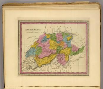
Switzerland.
1 : 1300000 Finley, Anthony
Carte scolaire de la Suisse
1 : 600000 Švýcarsko Kümmerly, H. Kümmerly & Frey
Helvetien und Wallis
Švýcarsko Mechel, Christian von Weiss, Johann Heinrich im Verlage des Kunst u. Industrie Comptoirs
Der Helvetischen Republik neue Cantons und Districts Eintheilung
1 Karte : Typometrie ; 37 x 49 cm Haas Wilhelm Haas
Geologische Karte der Schweiz
1 : 500000 Švýcarsko Leuzinger, Rudolf Kommisionverlag von A. Francke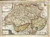
Les XIII. cantons des Suisses leurs alliez et leurs sujets
1 Karte : Kupferdruck ; 22 x 32 cm Fer; Inselin chez l'auteur dans l'isle du Palais a la sphere royale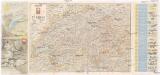
Reisekarte der Schweiz
1 : 750000 Švýcarsko Füssli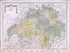
Karte von der Schweiz
1 Karte : Kupferdruck ; 45 x 63 cm bey Fuessli & Comp
Neüe Charte von Helvetien
1 Karte : Kupferdruck ; 45 x 63 cm bey Fuessli & Comp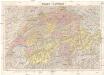
Suisse - Schweiz
1 : 300000 Švýcarsko Kümmerly & Frey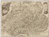
Neue Karte von der Schweiz oder Helvetien in die XIII Eidgenossenschaften, ihre Bundsverwandten und Unterthanen eingetheilt
1 : 543100 Švýcarsko Faden, W. F.A. Schraembl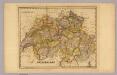
Switzerland.
1 : 1180000 DeSilver, Robert
Switzerland.
1 : 1140000 Darton, William
Nouvelle carte itinéraire dressée pour servir de guide aux voyageurs dans les XXII cantons de la Confédération Suisse = Neue Reise Karte verfertiget zum Behuf des Wegweisers durch die XXII Kantone der schweizerischen Eidgenossenschaft
1 : 700000 titelvariant: Neue Reise Karte verfertiget zum Behuf des Wegweisers durch die XXII Kantone der schweizerischen Eidgenossenschaft; Annotatie geografische gegevens: Met legenda en hoogtentabel Weiss, H. (fl. 1820) Á Berne : publié par I.I. Bourgdorfer
Die Helvetische Republik in Cantone und Districte eingetheilt
1 Karte : Typometrie ; 36 x 49 cm Haas gedruckt bey Wilhelm Haas dem Sohne
Carte genérale de la Suisse, oder, Die Helvetische Republik in XIX Cantone eingetheilt
1 : 529000 Švýcarsko
Nouvelle carte de la Suisse dans laquelle sont exactement distingués les treize cantons, leurs alliés et leurs sujets
1 Karte dréssée sur les mémoires les plus corrects et assujettie aux observations astronomiques [par William Faden] chez W. Faden, Charing Cross, Londre
Umriss von der Schweiz nach der neuen Eintheilung von 1798
1 Karte : Kupferdruck ; 36 x 48 cm s.n.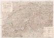
Post- und Reise-Karte der Schweiz nebst Theilen der angraenzenden Staaten
Švýcarsko Pfeiffer, J. B. Max Ravizza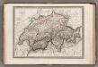
Suisse.
1 : 1020000 Monin, C.V.
Helvetische Republik
1 : 1665000 Švýcarsko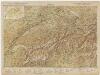
[Kaart], uit: Carte scolaire de la Suisse = Schulkarte der Schweiz / H. Kümmerly
1 : 600000 titelvariant: Schulkarte der Schwei; Annotatie: Op omslag (verso): statische gegevens; Annotatie geografische gegevens: Inzet: Politische Übersicht = Carte politique = Carta politica. - Schaal 1:2.750.000 H. Kümmerly Bern : Kümmerly & Frey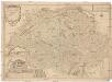
Les Suisses leurs sujets et leurs alliez
1 : 500000 Švýcarsko Fer, Nicolas de Dant Dant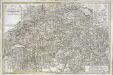
Carte de la Suisse ou l'on a marqué les routes suivies par M.re Wil. Coxe
1 Karte auf 2 Blatt : Kupferdruck ; 45 x 69 cm Coxe s.n.
Carte générale de la Suisse suivant les nouvelles divisions, qui comprennent les ci-devant XIII cantons, leurs alliés et sujets, et forment actuellement la république helvétique une et invisible
1 : 525000 Mechel, Christian von Chrétien de Mechel
[Recto], uit: Reiskaart van Zwitserland / kartografie: Kümmerly & Frey
1 : 600000 titelvariant: Kaart van Zwitserland; Annotatie: Omslagtitel: Kaart van Zwitserland Kümmerly + Frey, Bern Zürich [etc.] : Zwitsersche Verkeerscentrale