Maps of Québec

North America 2.
1 : 4470000 Arrowsmith, Aaron
Carte nouvelle de l'Amerique angloise : contenant tout ce que les Anglois possedent sur le continent de l'Amerique septentrionale savoir le Canada, la Nouvelle Ecosse ou Acadie, les treize provinces unies qui sont: les quatres colonies de la Nouvelle Ang
from Charts and maps
Carte nouvelle de l'Amerique angloise : contenant tout ce que les Anglois possedent sur le continent de l'Amerique septentrionale voir le Canada, la Nouvelle Ecosse ou Acadie, les treize provinces unies qui sont: les quatres colonies de la Nouvelle Angle
from Charts and maps
A new and exact map of the dominions of the King of Great Britain on ye continent of North America : containing Newfoundland, New Scotland, New England, New York, New Jersey, Pensilvania, Maryland, Virginia and Carolina / according to the newest and most
from The world described, or, A new and correct sett of maps : shewing the kingdoms and states in all the known parts of the earth, with the principal cities, and most considerable towns in the world ... / ... by Herman Moll, geographer ...
A map of the British-plantations on the continent of America / Stephens fecit.
from Charts and maps Stephens fecit,
Canada et Louisiane / par le Sr. le Rouge ingénieur géographe du Roy.
from Charts and maps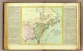
Possessions Francoises.
1 : 12500000 Clouet, J. B. L. (Jean-Baptiste Louis), b. 1730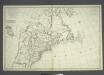
Carte nouvelle de l'Amerique angloise: contenant la Virginie, Mary-Land, Caroline, Pensylvania, Nouvelle Iorck, N. Iarsey, N. France, et les terres nouvellement decouerte dressé sur les relations les plus nouvelles / par le Sieur S.
from John H. Levine Collection le Sieur S.,
A new map of the British colonies in North America : shewing the seat of the present war, taken from the best surveys, compared with and improved from manuscripts of several noblemen and gentlemen / by John Andrews.
from Charts and maps
A new map of North America from the latest discoveries / J. Spilsbury, sculp.
from Parts J. Spilsbury,
Canada et Louisiane
1 : 5000000 par le Sr. Le Rouge A Paris : [Le Rouge], Rue des Augustins]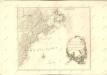

Carte des Possessions Angloises & Françoises du Continent de l'Amerique Septentrionale
1 : 6900000 Mollova mapová sbírka Gosse, Pierre
A new and exact map of the dominions of the King of Great Britain on ye continent of North America: containing Newfoundland, New Scotland, New England, New York, New Jersey, Pensilvania, Maryland, Virginia and Carolina / according to the newest and most exact observations by Herman Moll, geographer.
from John H. Levine Collection Herman Moll,
Canada et Louisiane
Kanada Le Rouge, Georges-Louis le Rouge
North America.
1 : 6500000 Jefferys, Thomas
Carte du theatre de la guerre presente en Amerique / dressée d'après les nouvelles cartes anglaises par L. Denis, géographe et auteur du conducteur français.
from Charts and maps

A new map of the English empire in America: viz. Virginia, Maryland, Carolina, New York, New Iarsey, New England, Pennsylvania, Newfoundland, New France &c. / revis'd by Ion. Senex, 1719; I. Harris, sculp.
from John H. Levine Collection John Senex; I. Harris,
A new map of the English empire in America: viz. Virginia, Maryland, Carolina, New York, New Iarsey, New England, Pennsylvania, Newfoundland, New France &c. / revis'd by Ion. Senex, 1719; I. Harris, sculp.
from Charts and maps John Senex; I. Harris,
The United States of North America, with the British & Spanish territories according to the Treaty of 1784 / engrav'd by Wm. Faden, 1785.
from Charts and maps William Faden,
America Septentrionalis a Domino d'Anville in Galliis edita nunc in Anglia: Coloniis in interiorem Virginiam deductis nec non Fluvii Ohio cursu aucta notisque geographicis et historicis illustrata / Sumptibus Homannianorum Heredum.
from Charts and maps Sumptibus Homannianorum Heredum,
Virginia et Nova Francia.
from Charts and maps Sumptibus et typis aeneis Iudoci Hondij: [Amsterdami]; Bertius, Petrus. La geographie racourcie.; Hondius, Jodocus,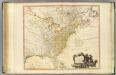
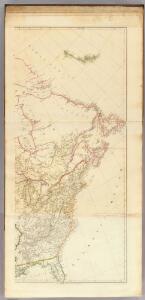
United States of North America.
1 : 6350000 Faden, William, 1750?-1836

United States
A new general atlas of modern geography, consisting of a complete collection of maps of the four quarters of the globe Wyld, James James Wyld
AMERICA SEPTENTRIONALIS
1 : 6300000 Ohio, řeka-oblast Anville, Jean-Baptiste Bourguinon d' sumptibus ab Homannianorum Heredum
America Septentrionalis
1 : 6500000 Spojené státy americké-oblast východní Anville, Jean-Baptiste Bourguinon d' ab Homanniorum Heredum