Maps of Lure
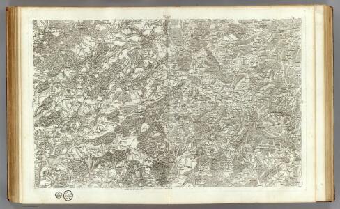
144 Luxeuil.
1 : 86400 Cassini family; Cassini, Cesar-Francois, 1714-1784
[Luxeuil]
1 Blatt : 61 x 91 cm s.n.
Montagnes françaises
1 : 80000 Francie
Meßtischblatt 3682 : Masmünster, 1886
1 : 250000 Masmünster. - Aufn. 1885. - 1:25000. - [Berlin]: Reichsamt für Landesaufnahme, 1886. - 1 Kt.
Meßtischblatt 3675 : Urbis, 1887
1 : 250000 Urbis. - Aufn. 1885. - 1:25000. - [Berlin]: Reichsamt für Landesaufnahme, 1887. - 1 Kt.
Meßtischblatt 3667 : Wildenstein, 1885
1 : 250000 Wildenstein. - Aufn. 1884. - 1:25000. - [Berlin]: Reichsamt für Landesaufnahme, 1885. - 1 Kt.
Meßtischblatt 3683 : Sentheim, 1887
1 : 250000 Sentheim. - Aufn. 1885. - 1:25000. - [Berlin]: Reichsamt für Landesaufnahme, 1887. - 1 Kt.
Meßtischblatt 3676 : Thann, 1897
1 : 250000 Thann. - Aufn. 1895. - 1:25000. - [Berlin]: Reichsamt für Landesaufnahme, 1897. - 1 Kt.
Meßtischblatt 3668 : Lautenbach, 1886
1 : 250000 Lautenbach. - Aufn. 1884. - 1:25000. - [Berlin]: Reichsamt für Landesaufnahme, 1886. - 1 Kt.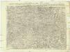
Carte topographique d'Allemagne
1 : 224000 Alsasko (Francie) Jaeger, Johann Wilhelm Abraham I.W.A. Iaeger
Carte topographique d'Allemagne
1 : 224000 Alsasko (Francie) Jaeger, Johann Wilhelm Abraham I. W. A. Iaeger
Colmar 140, uit: Special-Karte von Mittel-Europa / nach amtlichen Quellen bearbeitet von W. Liebenow
1 : 300000 titelvariant: W. Liebenow's Mittel-Europa; Annotatie: Titel boven de bladen: W. Liebenow's Mittel-Europa Johannes Wilhelm Liebenow 1822-1897 Frankfurt a. M. : Ludwig Ravenstein
Sequani Partie des Archidconnes de Favernay et de Luxeuil du Dioecese de Besancon
1 : 240000 Mollova mapová sbírka Sanson, Nicolas Somer, Jean Pruthenus Sanson, Nicolas
Colmar 140, uit: [W. Liebenow's Special-Karte von Mittel-Europa]
1 : 300000 titelvariant: W. Liebenow's Mittel-Europa; Annotatie: Titel boven de bladen: W. Liebenow's Mittel-Europa Johannes Wilhelm Liebenow 1822-1897 Hannover : Hermann Oppermann
184. Gebweiler, uit: Topographische Uebersichtskarte des Deutschen Reiches / herausgegeben v. d. Kartogr. Abt. d. Königl. Preuß. Landesaufnahme
1 : 200000 titelvariant: Topogr. Übersichtskarte des Deutschen Reiches; Annotatie: Titel boven bladen ook: Topogr. Übersichtskarte des Deutschen Reiches; Annotatie geografische gegevens: Op elk blad twee maatstokken: 10 Kilometer = 5,5 cm; 1 geogr. Meile = 3,6 cm; Legenda onder op elk blad Königlich Preußische Landesaufnahme. Kartographische Abtheilung [S.l : Königlich Preußische Landesaufnahme, Kartographische Abtheilung]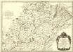
Sequani Partie des Archidconnes. de Favernay et de Luxeuil du Dioecese de Besançon
1 : 240000 Mollova mapová sbírka Sanson, Nicolas Somer, Jean Pruthenus Mariette, Pierre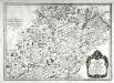
Sequani
1 Karte : Kupferdruck ; 39 x 55 cm Sanson; Robert de Vaugondy; Somer chés le S Robert geogr. ord. du roy quai de l'Horloge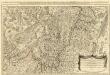
Les Prevotez Offices Senéchaussée, et Comté, qui font Partie de Balliages de Vosge ou Mirecour et de Nancy, dans le Duché Lorraine les Terres Adjacentes d'Épinal, de Chaté &c. :
1 : 180000 Mollova mapová sbírka Jaillot, Alexis-Hubert Jaillot, Alexis Hubert
Belfort

Le Flambeau de la Guerre Allumee au Rhin
Mollova mapová sbírka Delisle, Guillaume Schenk, Peter II
Meßtischblatt 3660 : Münster (Im Elsass), 1886
1 : 250000 Münster (Im Elsass). - Aufn. 1884. - 1:25000. - [Berlin]: Reichsamt für Landesaufnahme, 1886. - 1 Kt.
Meßtischblatt 3687: Dammerkirch, 1887
1 : 250000 Dammerkirch. - Aufn. 1885. - 1:25000. - [Berlin]: Reichsamt für Landesaufnahme, 1887. - 1 Kt.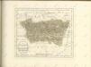

Carte topographique d'Allemagne contenant une partie du duché de Lorraine, d'Allsas et du margraviat superieur de Baaden-Durlach, l'évêcé de Basel, une partie de la Suisse savoir les cantons de Basel et Solothurn, le territoire de Biel, une partie de la Franche-Comté et de la Bourgogne
1 Karte fait par I.W. Iaeger chez l'auteur, Francfort sur le Mein
Belfort und die Vogesen aus der Vogelschau

Notes Gëographiques, uit: [Alsace-Franche-Comté / Bacler d'Albe]
1 : 250000 Backler d'Albe, L. A. G. [Milan : s.n.]
Civitas Leucorum sive Pagus Tullensis aujourdhui le Diocese de Toul Pour servier a l'Histoire de ce Diocese
1 : 310000 Mollova mapová sbírka Delisle, Guillaume Covens, Johannes I
Département de la Haute Saone
1 : 260000 Haute-Saône (Francie) Chanlaire, Pierre-Grégoire P.G. Chanlaire
Carte du gouvernement général du comté de Bourgogne ou Franche-Comté
1 Karte : Kupferdruck ; 67 x 48 cm Delafosse; Croisey; Daumont; Auvray chéz le S. Daumont ruë S. Martin près S. Julien