Maps of Dole
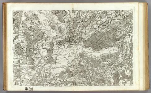
115 Dole, Auxonne.
1 : 86400 Cassini family; Cassini, Cesar-Francois, 1714-1784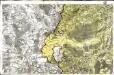
[Dole - Auxonne]
1 Blatt : 60 x 92 cm Le Roy s.n.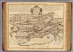
Neuchatel, Vallangin.
1 : 100000 L'Isle, Guillaume de, 1675-1726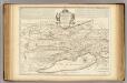
Neuchatel, Vallangin.
1 : 100000 Merveilleux, David Francois de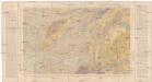
Besançon
1 : 80000 Besançon (Francie) Bertrand, Marcel Alexandre Service de la carte géologique de la France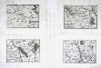
Govvernement de Beaulne
1 Karte : Kupferdruck ; 11 x 15 cm Sebastian Cramoisy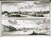
Besançon
1 Plan : Kupferdruck ; 21 x 28 cm Fer chez de Fer dans l'isle du Palais a la sphere royalle
Colored plan of Bellegarde or Seurre
A colored manuscript plan of Bellegarde or Seurre, France, with schemes for extended fortifications; drawn on a scale of 20 toises to an inch.
Département du Jura
1 : 260000 Jura (Francie) Houdan, François d' P. G. Chanlaire
Département du Jura
1 Karte : Kupferdruck ; 40 x 35 cm Capitaine s.n.
Département du Jura
1 Karte : Kupferdruck ; 49 x 48 cm Houdan; Dumez chez Dumez directeur de l'Atlas national rue de la Harpe no. 26
Dept. Du Jura.
1 : 571000 Levasseur, Victor.
[Atlas départemental : La France et ses colonies] No. 38 Jura
1 : 670000 publ. par Michel fils ainé [dressé par A. Lorrain, et gravé par H. Dandeleux] Versailles [etc.] : Barreswil et Andrieux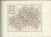
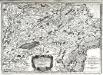
Sequani
1 Karte : Kupferdruck ; 39 x 56 cm Sanson; Robert de Vaugondy; Somer chez le S Robert geographe ordinaire du roy quai de l'Horloge du Palais
Sequani
1 Karte : Kupferdruck ; 42 x 55 cm Sanson; Robert de Vaugondy; Somer chés le S Robert geographe ord. du roy quai de l'Horloge du Palais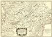
Partie du Dioec et Archche. de Besançon cujus Metropolis Visontio ou sont les Gr. Archidiacné. et celuy de Gray &c.
1 : 240000 Mollova mapová sbírka Sanson, Nicolas Somer, Jean Pruthenus Sanson, Nicolas
Sequani. Archidne. de Salins du Dioecese de Besancon
1 : 240000 Mollova mapová sbírka Sanson, Nicolas Somer, Jean Pruthenus Sanson, Guillaume
Dijon 153, uit: Special-Karte von Mittel-Europa / nach amtlichen Quellen bearbeitet von W. Liebenow
1 : 300000 titelvariant: W. Liebenow's Mittel-Europa; Annotatie: Titel boven de bladen: W. Liebenow's Mittel-Europa Johannes Wilhelm Liebenow 1822-1897 Frankfurt a. M. : Ludwig Ravenstein
Dijon 153, uit: [W. Liebenow's Special-Karte von Mittel-Europa]
1 : 300000 titelvariant: W. Liebenow's Mittel-Europa; Annotatie: Titel boven de bladen: W. Liebenow's Mittel-Europa Johannes Wilhelm Liebenow 1822-1897 Hannover : Hermann Oppermann
[Kaart], uit: Plan de Besançon : avec notice historique et guide pour la visite de la ville et des environs
1 : 8000 Annotatie geografische gegevens: Water blauw Besançon : Girardot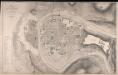
Plan De La Ville De Besançon
1 : 3000 Kirwan, J. J. Lemercier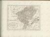

Comitatus Burgundiae, Vulgo la Franche Comté
1 : 400000 Mollova mapová sbírka Danckerts, Cornelis Danckerts, Cornelis
23) IX.N.O. ''Dijon'', uit: Carte géologique de France
1 : 500000 Annotatie: Voor aanwezige bladen zie bladoverzicht [S.l : s.n.]
Le Comté de Bourgogne dit Franche-Comté Divisé en ses Quatre Grands Balliages d'Amont, d'Aval, de Dole, et de Besançon
1 : 330000 Mollova mapová sbírka Fer, Nicolas de Starckman, P. Bénard, Jacques-François
Superior Burgundiae Comitatus Vulgo la Franche Comte Complectens Praefecturas Amontii Dolae Avalli Quibus Adjacetus Comitatus Montis Balliardi
1 : 410000 Mollova mapová sbírka Valk, Gerhard Valck, Gerard
Le comté de Bourgogne ou la Franche comté
1 : 371000 Burgundsko (Francie) Crepy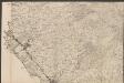
La Franche Comté divisée en Trois Grandes Balliages, sçavoir D'Amont, D'Aval, et Du Milieu ou De Dole [...] [Karte], in: Atlas nouveau, contenant toutes les parties du monde [...], Bd. 1, S. 139.
1 Karte aus Atlas Sanson, Nicolas Jaillot, Alexis Hubert und Mortier, Pieter