Maps of Hornoy-le-Bourg
24 Forges, Neufchatel.
1 : 86400 Cassini family; Cassini, Cesar-Francois, 1714-1784
Carte particuliere du diocese de Rouen, 3
1 Blatt : Dezauche
Département de l'Oise
1 Karte : Kupferdruck ; 49 x 48 cm Houdan au bureau de l'atlas national de France rue Serpente no. 15 et au cabinet bibliographique rue de la Monnoye no. 5
Le Canal et Partie de la France
1 : 250000 Mollova mapová sbírka Seutter, Matthäus Lotter, Tobias Conrad Seutter, Matthäus
Carte de la Picardie
1 Karte : Kupferdruck ; 50 x 64 cm Vauchelle; Agnes chez Agnes
Picardie meridionale.
1 : 210000 L'Isle, Guillaume de, 1675-1726
Picardie meridionale.
1 : 210000 L'Isle, Guillaume de, 1675-1726
Partie meridionale de Picardie
1 Karte : Kupferdruck ; 47 x 61 cm L'Isle; Rousseville; Des Rosiers; Lesperon chez l'auteur sur le quai de l'Horloge
Stoel des Oorlogs in Picardyen, Isle de France enz: Têatre de la Guerre en Picardie, Isle de France &c.
1 : 250000 Mollova mapová sbírka Allard, Abraham Allart, Abraham
Comitatus Bellovacum, Vernaculè Beuvais. [Karte], in: Theatrum orbis terrarum, sive, Atlas novus, Bd. 2, S. 25.
1 Karte aus Atlas Blaeu, Joan Blaeu, Willem Janszoon
Comitatus Bellovacum, Vernaculè Beauvais. [Karte], in: Novus Atlas, das ist, Weltbeschreibung, Bd. 2, S. 42.
1 Karte aus Atlas Blaeu, Joan Blaeu, Willem Janszoon
Comitatus Bellovacum, Vernaculè Beauvais. [Karte], in: Le théâtre du monde, ou, Nouvel atlas contenant les chartes et descriptions de tous les païs de la terre, Bd. 2, S. 42.
1 Karte aus Atlas Blaeu, Willem Janszoon und Blaeu, Joan Blaeu, Willem Janszoon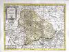
Beauvaisis
1 Karte : Kupferdruck ; 35 x 48 cm Valck; Schenk apud G. Valk et P. Schenk
COMITATVS | BELLOVACVM, | Vernaculè | BEAVVAIS
Amsterdami | Apud Guiljelmum et Joannem Blaeu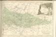

Ambiani
1 Karte : Kupferdruck ; 38 x 40 cm Sanson; Robert de Vaugondy; Cordier chez le Sr. Robert g. du r. quai de l'Horloge

Comitatvs Bellovacvm
1 : 208000 Blaeu, Joan apud Guilielmum et Joanne Blaeu
Belovacium comitatus
1 Karte : Kupferdruck ; 17 x 24 cm Mercator; Keere Cloppenburgh

Comitatvs Bellovacvm, vernaculè Beavvais
1 Karte : Kupferdruck ; 36 x 48 cm Blaeu; Blaeu apud Guiljelmum et et Joannes Blaeu
Beauvaisis
1 Karte : Kupferdruck ; 36 x 48 cm Hondius; Hondius Judocus Hondius ex.dit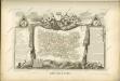

Les isles de Jersey, Guernsey, Alderney, ou Aurigny
Jersey, ostrov (Normanské ostrovy) Kitchin, Thomas Le Rouge, Georges-Louis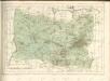
[Amiens]
1 Blatt : 60 x 91 cm s.n.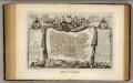
Dept. De L'Oise.
1 : 563000 Levasseur, Victor.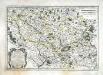
Bellovaci, et Silvanectes
1 Karte : Kupferdruck ; 34 x 49 cm Sanson; Robert de Vaugondy ches le S. Robert geog. du r. quai de lhorloge
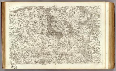
3 Amiens.
1 : 86400 Cassini family; Cassini, Cesar-Francois, 1714-1784