Maps of Lower Saxony

The north west part of Germany.
1 : 2500000 Moll, Herman, d. 1732
Karte von Deutschland in IV Blättern
1 : 825000 Nordwest-Blatt Sotzmann, Daniel Friedrich im Verlage der A. G. Schneider und Weigels
Allemagne du N.O.
1 : 1500000 Vivien St Martin, L.
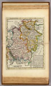
NW pt. of Germany.
1 : 2150000 Bowen, Emanuel
Germany N. of Mayne.
1 : 1200000 Thomson, John
Germany. Deutschland I.
1 : 1760000 Society for the Diffusion of Useful Knowledge (Great Britain)
Eisenbahnkarte von Nordwest-Deutschland
1 : 2000000 Německo severozápadní Geograph. Anstalt von Wagner & Debes
The North West Part of Germany
1 : 2500000 Mollova mapová sbírka Moll, Herman Moll, Hermann
Circulus Westphaliae cum omnibus suis subjacentibus provinciis novissima delineatio
1 : 1000000 1 Karte : Kupferdruck ; 49 x 56 cm Danckerts, Justus [Danckerts]
Germany - western section.
1 : 1000000 John Bartholomew and Son
Nordwest-Deutschland
1 : 2000000 Německo severozápadní Kocen, Blaž E. Hölzel
CIRCULUS WESTPHALICUS IN SUAS PROVINCIAS ET DITIONES accurate distinctus et recentissime delineat
1 : 1100000 Vestfálsko (Německo) Seutter, Matthäus cura et caelo Matth. Seutteri
Circulus Westphalicus in suas provincias et dittiones
1 : 1040000 Vestfálsko (Německo) Seutter, Matthäus cura et caelo Matth. Seutteri
Circulus Westphalicus in suas provincias et dittiones
1 : 1040000 Vestfálsko (Německo) Seutter, Matthäus cura et caelo Matth. Seutteri
Circulus Westphalicus
1 : 1000000 Mollova mapová sbírka Seutter, Matthäus Seutter, Matthäus
Circulus Westphaliae cum Omnibus Suis Subjacentibus Provinciis Novissima Delineatio
1 : 1000000 Mollova mapová sbírka Ottens, Josua Ottens, Josua
Circulus Westphalicus in suas provincias et ditiones accurate distinctus et recentissime delineat
1 : 1000000 cura et caelo Matth. Seutteri S.C.M.G. G. Matthaeus Seüter jun. sculpsit. Aug. Vind : [Matthäus Seutter]
German Federal Republic. Pergamon World Atlas.
Polish Army Topography Service
Nordwestliches Deutschland, Niederlande und Belgien
1 : 3441000 Belgie Justus Perthes
German Empire 1.
1 : 1774080 Letts, Son & Co.
Northern and Central Germany.
1 : 2154240 Fullarton, A. & Co.
Germany north.
1 : 2800000 Arrowsmith, Aaron; Lewis, Samuel
Germany north.
1 : 2800000 Arrowsmith, Aaron; Lewis, Samuel
Operationen der alliirten und französischen Armee 1759

Demarcations-Linie welche Kraft dem am 17. May 1795 zwischen Frankreich und Preussen geschlossenen Vergleich bestimmt : wie weit die Franzosen disseits des Rheins in Deutschland vordringen dürffen
1 : 1300000 Augsburg : Johann Walch
Nordwestliches Deutschland, Niederlande und Belgien

Germany (Deutschland)
1 : 1776000 Hannover (Německo) Walker, C. Baldwin & Cradock
Nordwestliches Deutschland, Niederlande und Belgien
Schul-Atlas über alle Theile der Erde nach dem neuesten Zustande, und über das Weltgebäude Stieler, Adolf bei Justus Perthes
[Hannover, Braunschweig, Kurhessen, Gr. Herz. Hessen, Hess. Homburg]
Schul-Atlas in 36 Karten Völter, Daniel Verlag der J.M. Dannheimer'schen Buchhandlung