Maps of Coastal Plain

United States.
1 : 1900800 Varle, Charles P.
Mitchell's National Map of the American Republic
1 : 3400000 Mitchell, Samuel Augustus
Mitchell's Reference & Distance Map Of The United States.
1 : 1584000 Young, James H.
Mitchell's Reference & Distance Map Of The United States.
1 : 1584000 Young, James H.
New Map of the United States.
1 : 1584000 Young, James H.
Chapin's Ornamental Map Of The United States.
1 : 2217600 Taylor, J.B.
Mitchell's Reference & Distance Map Of The United States.
1 : 1584000 Young, James H.
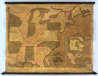
Map Of The United States.
1 : 11000000 Barber, John Warner
United States.
1 : 1500000 Smith, J. Calvin
United States Of North America.
1 : 1550000 Arrowsmith, Aaron
Map Of The United States
1 : 2300000 Vance, David H.
Ensign's Travellers' guide and map of the United States : containing the roads, distances, steam boat and canal routes &c. / engraved on steel by J. Wells, Brooklyn, L.I.
from Whole
An improved map of the United States

United States.
1 : 11800000 Darton, William
The Seat of Civil War in America.
The Seat of Civil War in America. Published by Smith & Son of London in August 1863, The Seat of Civil War in America highlights the Union and Confederate states, as well as clearly marking the Border States in yellow. Interestingly this map still presents Virginia as one state. The smaller map shows the Seat of War in Virginia, detailing the areas of the state closest to Maryland and Washington, D.C., as well as southern Pennsylvania. Smith & Son
Alden's Pictorial Map Of The United States Of North America.
1 : 2851200 Alden, Albert
Map of the United States Of North America.
1 : 1837440 Burr, David H., 1803-1875
Etats-Unis, Canada, Floride.
1 : 13500000 Delamarche, Charles Francois; Lattre, Jean
Karte der katholischen Diocesen und deren Missionen in Nordamerika nach den neuesten geographischen Angaben
1 : 22430000 Spojené státy americké-oblast východní Salzbacher, Joseph Engel, H. Joseph Salzbacher
United States.
1 : 1500000 Smith, J. Calvin
United States.
1 : 11400000 Finley, Anthony
US Population 1830, 1840.
1 : 10040000 Walker, Francis Amasa, 1840-1897
United States.
1 : 8000000 Tanner, Henry S.
United States.
1 : 8000000 Tanner, Henry S.
United States of America.
1 : 5900000 Cary, John, ca. 1754-1835
A new map of the United States of America, from the latest authorities / by John Cary, engraver.
from Whole John Cary,
Mitchell's Reference & Distance Map Of The United States.
1 : 1584000 Young, James H.
United States.
1 : 9200000 Greenleaf, Jeremiah
United States.
1 : 9250000 Greenleaf, Jeremiah