Maps of Illinois

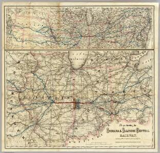
Maps showing the Indiana & Illinois Central Railway.
1 : 1267200 G.W. & C.B. Colton & Co.
Western States.
1 : 3000000 Olney, J. (Jesse), 1798-1872
Western States.
1 : 3000000 Huntington, Francis Junius, 1802-1878
Ohio, Indiana, Illinois, Michigan.
1 : 2063000 Finley, Anthony
Western States.
1 : 4200000 Huntington, Nathaniel G. (Nathaniel Gilbert), 1785-1848
Western States.
1 : 6400000 Adams, Daniel
Western States, United States.
Goodrich, S.G.
Map of the Western States.
1 : 3200000 Mitchell, Samuel Augustus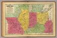
Western States.
1 : 3200000 Mitchell, Samuel Augustus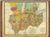
Ohio, Indiana & Illinois And Part Of Michigan Territory.
1 : 2060000 Mitchell, Samuel Augustus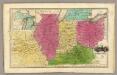
Western States. (with) inset map of Upper Michigan.
1 : 3000000 Smiley, Thomas T.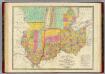
Map of the States Of Ohio Indiana & Illinois And Part Of Michigan Territory.
1 : 2000000 Finley, Anthony
Ohio, Indiana & Illinois.
1 : 2400000 Black, Adam & Charles
Map of part of the N: W: Territory of the United States.
1 : 1013760 Carey, Mathew
Ohio, Indiana, Kentucky, and Tennessee.
1 : 3651000 Fisher, Richard Swainson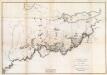
General Map of the Course of the Ohio.
1 : 563200 Tardieu, P.F.
Map Pittsburgh & Western Railway Co.
1 : 5844000 Pittsburgh & Western Railway Company
E. United States 5.
1 : 1774080 Letts, Son & Co.
[Neueste Karte von Illionois mit seinen Strassen, Entfernungen der Hauptpunkte und Routen für Dampfschiffe]
Grosser Hand-Atlas über alle Theile der Erde in 170 Karten Meyer, J. Verlag des Bibliographischen Instituts
Illinois, Indiana, Ohio.
1 : 1584000 Smith, J. Calvin
Illinois.
1 : 1800000 Mitchell, Samuel Augustus
Illinois.
1 : 1800000 Mitchell, Samuel Augustus
Illinois.
1 : 1900000 Schonberg & Co.
Illinois.
1 : 1740000 Colton, G.W.
Illinois.
1 : 1267200 Asher & Adams
Illinois.
1 : 1290000 Asher & Adams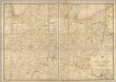
Post route map of the states of Ohio and Indiana with Cinncinnati and environs.
1 : 506880 United States. Post Office Dept.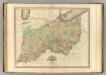
Ohio and Indiana.
1 : 1110000 Tanner, Henry S.
Illinois.
1 : 2000000 Colton, G.W.