Maps of Nassau County

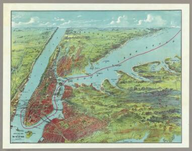
Birds Eye View Map Of New York And Vicinity.
1 : 80033 Hammond, C.S.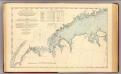
N.Y.-Norwalk Is.
1 : 80000 United States Coast Survey
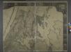
Upper section Index Map of Nassau County Long Island Published by E. Belcher Hype. 97 Liberty St. Brooklyn, 5 Beekman St. Manhattan. 1914.
from Atlas of Nassau County, Long Island, N.Y. Complete in one volume. Historical, statistical. Based upon maps on file at the county seat in Mineola and upon private plans and surveys furnished by surveyors and individual owners. Supplemented by careful measurements & field observations by our own corps of engineers.
New York City and Vicinity.
1 : 30000 Walling, H. F.
New York Island, Part of Long Island .
1 : 100000 Marshall, John
New map of Kings and Queens counties : from actual Surveys.
From Brooklyn
Colton's driving & wheeling map of the country twenty five miles north of the city of New York.
1 : 73000 G.W. & C.B. Colton & Co.
Country from Frog's Point to Croton River shewing the American and British Armies 1776.
1 : 120000 Marshall, John
A plan of the country from Frogspoint to Croton River shewing the positions of the American and British armies from the 12th of October 1776 until the engagement on the White Plains on the 28th
1 : 128400 Lewis, Samuel Wayne, Caleb Parry
Plate 32: Town of Oyster Bay.
from Atlas of Queens Co., Long Island, New York / compiled from official records, private plans & actual surveys by and under the direction of Chester Wolverton.
New Guide Map of Manhattan and The Bronx.
From Manhattan
Map of New York City showing portions of Brooklyn, Jersey City, and Westchester Co. on enlarged scale.
From Manhattan
Hagstrom ́s map of Manhattan and Bronx
General map of the city of New York, consisting of boroughs of Manhattan, Brooklyn, Bronx, Queens and Richmond : consolidated into one municipality by act of the legislature of the state of New York (Chapter 378 of the laws of 1897) : showing in addition
from Whole
Westchester, Double Page Plate No. 13 [Map of Towns of Scarsdale, New Rochelle, and Mamaroneck] / prepared under the direction of Joseph R. Bien, from general surveys and official records.
From Atlas of Westchester County, New York
Manhattan Borough and part of Bronx Borough of the City of New York.
From Manhattan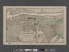
TheHeart of Greater New York, showing commercial facilities and tentative plans of development and recent additions.
From Manhattan
TheRand McNally map of the Borough of Manhattan, the principal portion of the Boroughs of Bronx, Brooklyn, and Queens and the business district of Jersey City.
From Manhattan
Westchester, Double Page Plate No. 17 [Map of Towns of White Plains, Harrison, and Rye] / prepared under the direction of Joseph R. Bien, from general surveys and official records.
From Atlas of Westchester County, New York
Colton's Map of the City of New York, prepared for the Department of Street Cleaning.
From Manhattan
Outline map of large scale real estate atlases of New York City, Borough of Manhattan.
from Atlas of the city of New York, borough of Manhattan / from actual surveys and official plans by George W. and Walter S. Bromley.
TheRand McNally map of the Borough of Manhattan.
From Manhattan
Plaines Blanches et Armees Americaine et Britannique, 12 Octobre1776.
1 : 130000 Marshall, John
Map of Queens Borough, City of New York.
From Queens
Outline Map of Large Scale Real Estate Atlases of New York City, Borough of Manhattan.
from Atlas of the city of New York, borough of Manhattan. From actual surveys and official plans / by George W. and Walter S. Bromley.
Map of the Hudson ... from Spuyten Duyvil to P. Livingston's.
from Map of the Hudson between Sandy Hook & Sandy Hill : with the post road between New York and Albany / Bridges delt. ; Rollinson sct.
BLOCK INDEX. Includes the map of Manhattan, Sections 1-8.
from Atlas of the city of New York, Manhattan Island. From actual surveys and official plans / by George W. and Walter S. Bromley.
New York City.
1 : 43000 Rand McNally and Company
TheRand McNally map of the Borough of Manhattan.
From Manhattan