Maps of Central Russian Upland

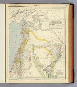
Syria.
1 : 2217600 Letts, Son & Co.
Die Haefen des Schwarzes Meeres an der asiatischen Küste
Asie západní Flemming
Schema dviženīja russkoj rati s 20 avgusta po 7 sentjabrja 1380 g.
Russland Kulikovo Pole Kulikowo Pole / Schlacht Dmitri, Moskau, Großfürst
Carte de la mer noire et de la mer d'Asow, 2
1 Blatt : 57 x 86 cm s.n.
Accurateste und wahre Abbildung des russischen Lagers und Retrenchement vor der türckischen Haupt-Vestung Assoff, samt einem beygesezten Landkärtel, worinn die völlige Situation derselben zu ersehen
Azov (Rusko) Baeck, Elias Elias Baeck
[Östl. Schwarzmeerküste]
1 : 1500000 Osmanisches Reich, Mingrelien
Russia 6.
1 : 2217600 Letts, Son & Co.
Russia in Europe Part VI.
1 : 2100000 Society for the Diffusion of Useful Knowledge (Great Britain)
Kaukasus 1.
1 : 2050000 Handtke, Friedrich H.
Théatre des opérations de la guerre dans la Tartarie du Cuban, Ozakow & Tartarie Crimée, avec les marches & rendés vous de l'armée de Russie contre les Turcs & Tartares, le tout suivant l'original de Pétersbourg, venant du camp de la Tartarie, Crimeé, mois de juillet [1]737
1 : 1680000 Ukrajina jižní Briffaut, E. chez le sieur Briffaut
Theatre des operations de la guerre dans la Tartarie du Cuban Ozakow & Tartarie Crimée, avec les marches & rendés vous de l'armée de Russie contre les Turcs & Tartares, le tout suivant l'original de Petersbourg, venant du camp de la Tartarie Crimeé mois de juillet [1]737
1 : 1680000 Ukrajina jižní Briffaut, E. chez le sieur Briffaut

Srednerusskaja černozemnaja oblast' v IX-XIII v.v: XI-XIII věka
Russland Zentralrussland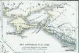
Das Bosporanische Reich
Bosporanisches Reich
Carte generale des expeditions militaires des armées victorieuses de sa Maieste imperiale de toutes les Russies sur le Don et le Dnepr l'an 1736
1 : 1690000 Dněpr-oblast
[Taurien]
Taurien (Gouvernement) Verwaltungsgliederung
Charte der Kriegs Operationen am Donn u: Dnieper Ihro Russisch Kayserl. Maiestaet glorieusen Armeen
1 : 1700000 1 Karte : Kupferdruck ; 38 x 44 cm (ganzes Blatt 54 x 64 cm) Seutter, Matthäus zu haben bey Matthaeus Seutter der röm: kayserl: u: königl: cathol: Majest: Geogr
[Südrussland]
1 : 1500000 Don-Gebiet, Jekaterinoslaw (Gouvernement)
Carte de la Mer Blanche
1 : 2900000 1 Karte : Kupferdruck ; 21 x 16 cm Bellin, Jacques Nicolas [Bellin]
Cimmeria, quae Postea Scythia Europaea Seu Parva Scythia / Ex Conatibus Geographicis Gulielmi Sanson
1 : 3000000 1 Karte : Kupferdruck ; 38 x 48 cm Sanson, Guillaume Apud I. Covens et C. Mortier
Paskaart van de Witte Zee
1 : 710000 1 Karte : Kupferdruck ; 51 x 58 cm Keulen, Johannes van by Iohannis Van Keulen
Des Russischen Reiches Statthalterschaften Woronesch, Belgorod Kiow o. Kleinrussland und Charkow od.
1 : 4000000 1 Karte : Kupferdruck ; 20 x 26 cm Reilly, Franz J. J. von [F. J. J. von Reilly]
Carte du gouvernement de Tauride comprenant la Krimée et les pays voisins
1 : 1150000 Krym (Ukrajina) par les freres Lotter
Itäinen Aunus
1 : 1000000 Olonec (Rusko : oblast) Tilgmannin kivipaino
A map of the lesser Tartary / done from the original, published by the Imperial Academy of Sciences
1 : 1700000 1 Karte : Kupferdruck ; 39 x 45 cm Senex, John [Iohn Senex]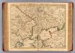
Theatre de la guerre, Petite Tartarie, Crimee, Mer Noire.
1 : 1250000 L'Isle, Guillaume de, 1675-1726
Russia Part lV.
1 : 1770000 Society for the Diffusion of Useful Knowledge (Great Britain)