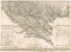
Maps of Dinaric Alps

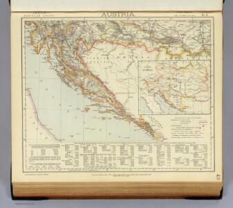
Austria 3.
1 : 1774080 Letts, Son & Co.
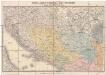
Austrian Dominions III.
1 : 1760000 Society for the Diffusion of Useful Knowledge (Great Britain)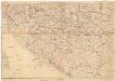
Verkehrskarte von Bosnien-Hercegovina und den angrenzenden Ländern
1 : 1000000 Albánie K. u. k. Militärgeographisches Institut
Die Südslavenländer
1 : 2500000 Chorvatsko Ed. Hölzel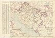
Nezavisna država hrvatska željezničkamreža i ostali prometni putovi

Dalmacie a země zavládnuté
Ortskarte von Bosnien, Herzegowina nebst Serbien, Montenegro u. Theilen der angrenzenden Länder
Bosna Steinhauser, Anton Artaria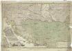
Neueste Karte der Koenigreiche Bosnien Servien Croatien und Slavonien
1 : 1140000 Bosna Schütz, Carl Müller, Franz Artaria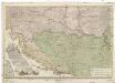
Neueste Karte der Koenigreiche Bosnien Servien Croatien und Slavonien
1 : 1140000 Bosna Schütz, Carl Müller, Franz Artaria Compagnie
Dalmatia, Sclavonia, Croatia, Bosnia, Servia et Istria distributa in singulares ditiones et dioeceses una cum republica Ragusana et circumjacentibus regionibus Hungaria, Venetiis, statu Eccleciastico, Neapoli et Macedonia
1 : 400000 Dalmácie (Chorvatsko) Valk, Gerhard Gerard et Leonard Valk
Dalmatia Sclavonia, Croatia, Bosnia, Servia et Istria
1 : 1400000 Mollova mapová sbírka Valk, Gerhard Valck, Gerard
Iustissimae causae heroica virtute propugnatae gloriosiß. triumphi praemium
Požarevac (Srbsko) Seutter, Matthäus sumptibus M. Seütteri
Iustissimae Causae Heroica Virtute propugnatae gloriosiß. Triumphi Praemium.
1 : 590000 Mollova mapová sbírka Seutter, Matthäus Seutter, Matthäus
Illyricum in Dalmatiam Chrobatiam Slavoniam et Serbliam divisum
1 : 4800000 Mollova mapová sbírka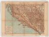
Dalmatien, Bosnien und Hercegovina. Sonderkarte 4
1 : 1000000 Relief shown by hachures and spot heights. Depths shown by isolines and soundings. Shows cities with populations, villages, main roads, railroads, forts and fortresses, beacons and telegraph lines. Language German Velhagen & Klasing Bielefeld and Leipzig: Velhagen & Klasing
Karte von Kroatien, Slavonien, der Militairgränze, Dalmatien, Bosnien, Serbien und Montenegro
1 : 1673850 Handtke, Friedrich Verlag von C. Flemming
Karte von Kroatien, Slavonien, der Militair-Gränze, Dalmatien, Bosnien, Serbien und Montenegro
1 : 1673850 Bosna Handtke, Friedrich Flemming, C. von C. Flemming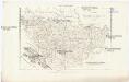
Charte von Bosnien und Servien
1 : 1767000 Bosna a Hercegovina Herz, W. Gleditsch
Composite XIII, XIV, XV, XVIII, XIX, XX: Karte Des Oesterreichischen Kaiserstaates.
1 : 576000 Scheda, Josef
G. Freytags Reisenkarte von Dalmatien, Bosnien und der Hercegovina
1 : 900000 Bosna Freytag, Gustav G. Freytag & Berndt
Dalmatia et regiones adjacentes, Croatia, Bosnia, Slavonia, Servia, Albania, accurate descriptae
1 : 1250000 Mollova mapová sbírka Monath, Peter Konrad Monath, Peter Konrad
Yugoslavia Selected Areas. Pergamon World Atlas.
1 : 1250000 Polish Army Topography Service
Dalmatia et regiones adjacentes, Croatia, Bosnia, Slavonia, Servia, Albania, accurate descriptae
1 : 1260000 Albánie Monath, Peter Konrad Petr Conr. Monath
Bosnien und Dalmatien
1 : 800000 Bosna Kiepert, Heinrich Boués, A. Geographisches Instituts
Bosnien und Dalmatien
1 : 800000 Bosna Kiepert, Heinrich Boués, A. Geographisches Instituts

[Chorvatsko a Srbsko]
Bosna a Hercegovina
Nova et Accurata Regnorum et Provinciarum Dalmatiae, Croatiae, Sclavoniae, Bosniae, Serviae, Istriae, et Reip. Ragusanae, cum Finitimis Regionibus Studio et Impensis
1 : 1400000 Mollova mapová sbírka Seutter, Matthäus Seutter, Matthäus
G. Freytags Karte der österreichisch-ungarischen Küstenländer
1 : 600000 Bosna a Hercegovina Freytag, Gustav G. Freytag & Berndt