Maps of Allegheny Plat.
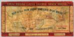
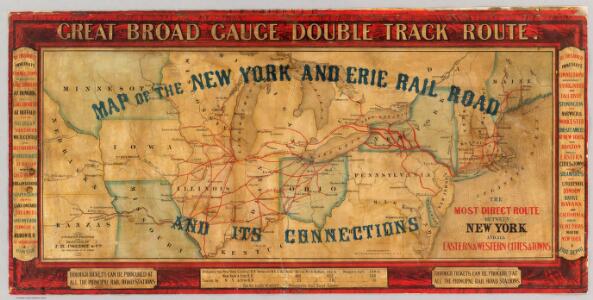
Map of the New York and Erie Rail Road and its connections.
1 : 3370000 New York And Erie Railway Company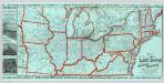
Lake Shore and Michigan So. Railway.
1 : 3431200 Lake Shore & Michigan Southern Railway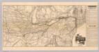
Map N.Y. Central & Hudson R. RR.
1 : 3104600 New York Central and Hudson River Railroad Company
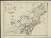
Map of the northern parts of the United States of America / by Abraham Bradley.
from Parts Abraham Bradley,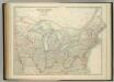
United States of North America (North East Sheet).
1 : 3984000 Johnston, W. & A.K.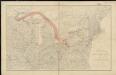
Distribution of the iron ores mined in the Lake Superior Region in year 1902
1 : 2500000 Birkinbine, John Geological Survey (U.S.)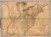
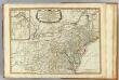
Map of the United States.
1 : 1950000 Bradley, Abraham Junior
Map of the United States of America / Gridley, sc.
from Whole Gridley,
Map of the United States of America / J. Melish, del.; H.S. Tanner, sc.
from Whole John Melish; Henry S. Tanner,
Map of the roads, canals and steam boat routes of the United States: with the distances from place to place carefully noticed ... / designed for the use of travellers by H.S. Tanner.
from Whole Henry S. Tanner,

Der Nördliche Theil der Vereinigten Staaten von Nord America
Hand-Atlas über alle Theile der Erde nach dem neuesten Zustande und über das Weltgebäude Stieler, Adolf bei Justus Perthes
Map New York Central Lines.
1 : 4200000 New York Central Railroad Company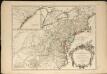
Partie de l'Amérique septentrionale, qui comprend le cours de l'Ohio, la Nlle. Angleterre, la Nlle York, le New Jersey, la Pensylvanie, le Maryland, la Virginie, la Caroline
1 : 3000000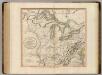
Western Terr., Kentucky, Pennsylvania, etc.
1 : 3300000 Cary, John, ca. 1754-1835
Skeleton map of the rail-roads between Cape Canso and St. Louis

Bowles's new one-sheet map of the independent states of Virginia, Maryland, Delaware, Pensylvania, New Jersey, New York, Connecticut, Rhode Island, &c. : comprehending also the habitations & hunting countries of the confederate Indians.
from Bowles's universal atlas. ...
A new and general map of the middle dominions belonging to the United States of America: viz. Virginia, Maryland, the Delaware-counties, Pennsylvania, New Jersey &c. with the addition of New York, & of the greatest part of New England &c as also of the bordering parts of the British possessions in Canada.
from Parts Published by Laurie & Whittle, No. 53 Fleet Street ...: London; Robert Laurie and James Whittle,
Nordoststaaten der Nordamerikanischen Union
1 : 3000000 New York (New York) Mielisch, H. Umbreit, E.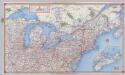
Shell Highway Map Northeastern Section of the United States.
1 : 3231360 Shell Oil Company
Vereinigte Staaten von Nord-Amerika in 6 blattern, bl. 3
Middle dominions U.S.
1 : 2200000 Robert Laurie & James Whittle
Part of North America: comprehending the course of Ohio, New England, New York, New Jersey, Pennsylvania, Maryland, Virginia, Carolina & Georgia.
from Parts
Post route map of the states of Kansas and Nebraska : showing post offices with the intermediate distances and mail routes in operation on the 1st of December, 1900 / published by order of Postmaster General Charles Emory Smith under the direction of ...
From Parts
[Die Vereinigten Staaten von Nord-Amerika, Blatt 3]
Handatlas über alle Theile der Erde und über das Weltgebäude Stieler, Adolf Justus Perthes
Phelps's national map of the United States: a travellers guide: embracing the principal rail roads, canals, steam boat & stage routes, throughout the union / drawn & engraved by J.M. Atwood, New York; portraits & st. arms engd. by Wm. D. Smith.
from Whole J. M. Atwood; Phelps; William D. Smith,
Nördlicher Theil der Vereinigten Staaten
Stieler's Hand-Atlas Stieler, Adolf bei Justus Perthes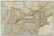
New travelling and commercial map of the Canadas: from the Sault of St. Marie to the river Saguenay, and a large section of the United States of America / compiled from the latest surveys and most approved authorities ... by his obliged obedient humble servant David Taylor, R.N., March 1834; engraved by S. Stiles & Co.
from Parts David Taylor; S. Stiles & Co.,
[Die Vereinigten Staaten von Amerika in 6 Blättern, Blatt 3]
Adolf Stieler's Handatlas über alle Theile der Erde und über das Weltgebäude Stieler, Adolf Justus Perthes